Download
1 / 88
890 likes | 1.08k Vues
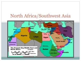
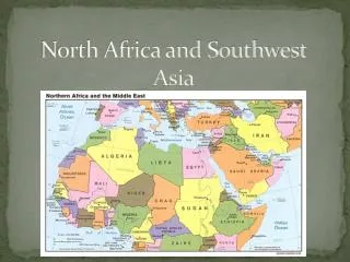
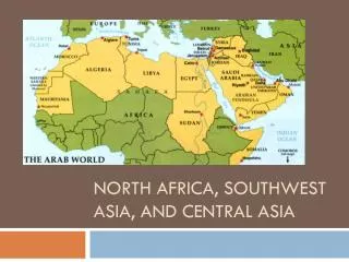
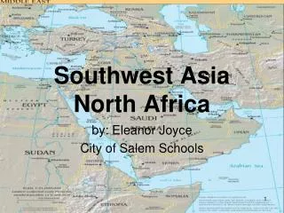
NORTH AFRICA AND SOUTHWEST ASIA TODAY CHAPTER 4. Section 4-1 North Africa (pages 100–104). Did You Know???.

E N D
Did You Know??? A common misconception about the Sahara, the world’s largest desert, is that a majority of its 3 1⁄2 million square miles is covered by sand. Most of this land, which is roughly equal to the size of the United States, is covered by rocky plateaus and gravelly plains, not sand.
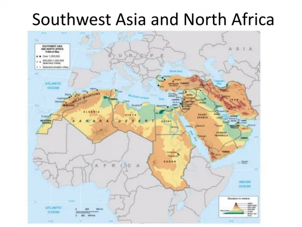
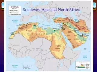
I. Egypt (pages 100–101) A. Egypt is about the same size as Texas and New Mexico together, yet most of it is desert.
I. Egypt (pages 100–101) B. The Nile River supplies 85 percent of the country’s water.
I. Egypt (pages 100–101) C. Dams and channels control the river’s flow and its use for farming and generating electric power.
I. Egypt (pages 100–101) D. The Suez Canal is one of the world’s most important waterways. Ships use the canal to pass from the Mediterranean Sea to the Red Sea, thereby avoiding traveling all the way around Africa.
I. Egypt (pages 100–101) E. About 40 percent of Egypt’s people work in agriculture raising sugar cane, grains, vegetables, fruits, and cotton.
I. Egypt (pages 100–101) F. Egyptian factories make food products, textiles, and consumer goods. Egypt’s main energy resource is oil. Another important industry is tourism.
II. Libya (pages 101–102) A. Except for the coastal lowlands, Libya is a desert with only a few oases. An oasis is a green area in a desert fed by underground water.
II. Libya (pages 101–102) B. The Sahara covers more than 90 percent of Libya.
II. Libya (pages 101–102) C. Libya has no permanent rivers, but aquifers lie beneath the vast desert. Aquifers are underground rock layers that store large amounts of water.
II. Libya (pages 101–102) D. Poor soil and a hot climate mean that Libya has to import about three-fourths of its food.
II. Libya (pages 101–102) E. The discovery of oil in Libya in 1959 brought the country great wealth.
II. Libya (pages 101–102) F. Almost all of Libya’s 5 million people have mixed Arab and Berber heritage. Eighty-six percent of Libyans live along the Mediterranean coast.
II. Libya (pages 101–102) G. Libya is a Muslim country, and most of its people speak Arabic.
II. Libya (pages 101–102) H. In 1969 a military officer named Muammar al-Qaddhafi overthrew the king and became a dictator. For many years, the United States and other democratic nations have accused Qaddhafi of encouraging terrorism.
III. The Maghreb (pages 102–104) A. Tunisia, Algeria, and Morocco form a region known as the Maghreb. These three countries make up the westernmost part of the Arabic-speaking Muslim world.
III. The Maghreb (pages 102–104) B. Tunisia is North Africa’s smallest country.
III. The Maghreb (pages 102–104) C. Tunisian farmers grow wheat, olives, fruits, and vegetables. Fishing is also an important industry. Tunisian factories produce food products, textiles, and oil products. Tourism is a growing industry.
III. The Maghreb (pages 102–104) D. Tunisia’s largest city today is Tunis, the capital city of more than 1 million people.
III. The Maghreb (pages 102–104) E. Algeria is the largest country in North Africa.
III. The Maghreb (pages 102–104) F. Algeria must import much of its food, which it pays for by selling oil and natural gas.
III. The Maghreb (pages 102–104) G. Algeria became a French possession in 1834, so many people in Algeria’s cities speak French as well as Arabic. In 1962, Algeria won its freedom from France.
III. The Maghreb (pages 102–104) H. Today, Algeria is a republic, with a strong president and a legislature. Since the early 1990s, however, there have been conflicts between the government and Muslim political parties.
III. The Maghreb (pages 102–104) I. Farmers in Morocco grow sugar beets, grains, fruits, and vegetables for sale to Europe during the winter. Morocco is a leading producer of phosphates, used in fertilizers. Tourism is also important to Morocco.
III. The Maghreb (pages 102–104) J. Morocco’s traditional culture is based on Arab, Berber, and African traditions.
III. The Maghreb (pages 102–104) K. Morocco is a constitutional monarchy.
Did You Know??? Turkey is home to some of the oldest permanent human settlements. In Çatal Hüyük, Turkey, archaeologists have unearthed some of the oldest known examples of pottery, textiles, and plastered walls. Some of these artifacts date back to 7000 B.C.
I. Turkey (pages 105–106) A. Turkey has a unique location—it bridges the continents of Asia and Europe. Three important waterways—the Bosporus, the Sea of Marmara, and the Dardanelles—separate the Asian and European parts.
I. Turkey (pages 105–106) B. Turkey’s climate varies throughout the country, from hot, dry summers and cold, snowy winters in the central plateau to hot, dry summers and mild, rainy winters on the coast.
I. Turkey (pages 105–106) C. Turkish farmers grow cotton, fruits, and wheat, and raise livestock. Turkey has many mineral resources such as coal, copper, and iron. Tourism is also a growing industry.
I. Turkey (pages 105–106) D. About 98percent of Turkey’s nearly 66 million people are Muslims.
I. Turkey (pages 105–106) E. The Kurds, an ethnic group who make up about 20 percent of Turkey’s people have demanded their own independent state.
I. Turkey (pages 105–106) F. Almost 70 percent of Turkey’s people live in cities or towns.
I. Turkey (pages 105–106) G. Istanbul began as a Greek port called Byzantium. Later it was renamed Constantinople. When the Ottomans conquered the city in the 1400s, they renamed it Istanbul.
I. Turkey (pages 105–106) H. Turkey has been a member of the North Atlantic Treaty Organization (NATO) since 1952 and is seeking to join the European Union.
II. Israel (pages 107–108) A. Israel is completely in Southwest Asia, but was founded by immigrants who came in large part from Europe, Central Asia, and the United States.
II. Israel (pages 107–108) B. Israel includes the mountains of Galilee, the Golan Heights, the Dead Sea, the desert of Negev, and the Jordan River.
II. Israel (pages 107–108) C. Israel’s best farmland stretches along the Mediterranean coastal plain and produces citrus fruits, such as oranges, grapefruits, and lemons.
II. Israel (pages 107–108) D. In very dry areas, Israel uses computers to release specific amounts of water from undergroundtubes to the roots of plants. As a result of technology, Israel’s farmers are able to export some food to other countries.
II. Israel (pages 107–108) E. Some Israelis live in farm settlements called kibbutzes, where property is shared. Other people live in moshavs where they share in farming, production, and selling, but may own private property as well.
II. Israel (pages 107–108) F. Israel’s skilled workforce produces electronicproducts, clothing, chemicals, food products, and machinery. Diamondcutting and polishing is also a major industry.
II. Israel (pages 107–108) G. Eightypercent of Israel’s people are Jews and the other 20percent are Palestinians, who are Arabic. There are many conflicts between these two groups.
Did You Know??? The northern segment of the Jordan Valley, known in Arabic as the Ghor, is Jordan’s most fertile region. It contains the Jordan River and extends from the country’s northern border south to the Dead Sea. Several degrees warmer than the rest of the country, its year-round mild climate, fertile soils, higher winter rainfall, and extensive summer irrigation have made the Ghor the food bowl of Jordan.
I. Syria (pages 110–111) A. Syria’s land includes fertile coastal plains and valleys along the Mediterranean Sea, and vast deserts covering the eastern regions.
I. Syria (pages 110–111) B. Agriculture is Syria’s main economic activity. Farmers raise mostly cotton, wheat, and fruits. The Euphrates River provides water for irrigation as well as hydroelectric power.
I. Syria (pages 110–111) C. Almost half of Syria’s 16 million people live in rural areas. A few are Bedouins—nomadic desert people who follow a traditional way of life.