Soils Landscape EE Program
This program led by Geomorphologist Tom Millard assesses soil, landscape, and program impact in forest regions. Evaluation questions cover soil loss, landslides, gully processes, and snow avalanches. Areas of focus include watersheds, coastal, and interior regions. Methods involve remote sensing, GIS data, and field sampling. Key indicators assess access structures, landslides, gully processes, and snow avalanches. Current progress includes one pilot study in Hellroaring Creek, with plans for more pilots next year. Additional GIS resources and recent aerial imagery are needed for future evaluations.

Soils Landscape EE Program
E N D
Presentation Transcript
Soils Landscape EE Program Tom MillardResearch GeomorphologistCoast Forest Region
Overview • Evaluation questions • Selection of evaluation areas • Methods • Indicators • Progress to date • Plans for next year
Evaluation questions • Do access structures have the least possible impact on productive soil loss and hydrologic function of the soil? • Are harvest or road-related landslides occurring? • Are harvest or road-related slides likely to occur as a result of recent forest practices? • Are harvest or road-related gully processes occurring? • Are harvest or road-related snow avalanches occurring?
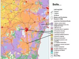
Evaluation areas • Watersheds 5000 – 10,000 ha in size • Need to decide on process for selecting watersheds • Coastal areas and some Interior areas – driven by landslide issues • Many Interior areas primarily soil disturbance/permanent access issues
Evaluation methods • Primarily remote sensing/GIS data collection and output • Field-level sub-sampling to confirm remote sensing results
Indicators – Access Structures • % of the productive forest area devoted to permanent access • Classify roads by type and condition • Compare to assumptions contained in TSR
Indicators – occurrence of landslides • Number of landslides occurring that are related to forest practices • Effect on soil productivity • Non-soil impacts (timber, fish habitat, community water supply, private property damage, injury/death of individuals)
Indicators – landslide likelihood • The likelihood of harvest or road-related slides occurring within approximately the next 15 years • Need to evaluate the amount of Class IV and Class V terrain harvested/roaded, or • Use Terrain Attribute Data to predict (approximately) the number of landslides expected to occur
Indicators – Gully processes • Inventory number and type of adverse gully processes • Remote sensing – scale issues
Indicators – snow avalanches • Some avalanche tracks identifiable from remote sensing • Needs work
Progress to date • One pilot in place – Hellroaring Creek near Cranbrook • Data being collected/summarized now
Plans for next year • 2 – 3 pilots: Coast, NIR and/or SIR • Need substantial GIS resources • Need very recent aerial photography/orthophotos/satellite imagery