Download
1 / 53
530 likes | 650 Vues
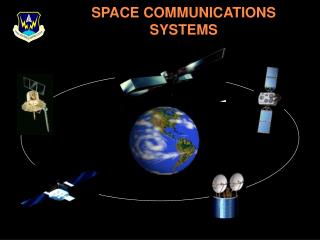
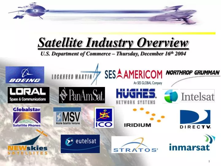
Satellite Industry Overview U.S. Department of Commerce – Thursday, December 16 th 2004. Value of Satellite Systems. Value of satellite systems grows with widely distributed networks and mobility of users Satellite systems perform most effectively when:

E N D
Satellite Industry OverviewU.S. Department of Commerce – Thursday, December 16th 2004
Value of Satellite Systems • Value of satellite systems grows with widely distributed networks and mobility of users • Satellite systems perform most effectively when: • interconnecting wide distributed networks, • providing broadcasting services over very wide areas such as a country, region, or entire hemisphere • providing connectivity for the “last mile” in cases where fiber networks are simply not available for interactive services. • providing mobile wideband and narrow band communications • satellites are best and most reliable form of communications in the case of natural disasters or terrorist attacks - fiber networks or even terrestrial wireless can be disrupted bytsunamis, earthquakes, etc..
“Typical” Fixed Satellite Network • Applications • Credit Card Validation • ATM/Pay at the Pump • Inventory Control • Store Monitoring • Electronic Pricing • Training Videos • In-Store Audio • Broadband Internet Access • Distance Learning Network HUB Apartment Buildings Internet Gas Stations Corporate Data Center/HQ Corporate Offices Residential Branch Offices Some large scale corporate networks have as many as 10,000 nodes
Orbital Options • A Geosynchronous satellite (GEO) completes one revolution around the world every 23 hrs and 56 minutes in order to maintain continuous positioning above the earth’s sub-satellite point on the equator. • A medium earth orbit satellite (MEO) requires a constellation of 10 to 18 satellites in order to maintain constant coverage of the earth. • A low earth orbit satellite (LEO) offers reduced signal loss since these satellites are 20 to 40 times closer to the earth in their orbits thus allowing for smaller user terminals/antennas.
Geostationary Orbit (GEO) Characteristics of Geostationary (GEO) Orbit Systems • User terminals do not have to track the satellite • Only a few satellites can provide global coverage • Maximum life-time (15 years or more) • Above Van Allen Belt Radiation • Often the lowest cost system and simplest in terms of tracking and high speed switching Challenges of Geostationary (GEO) Orbit • Transmission latency or delay of 250 millisecond to complete up/down link • Satellite antennas must be of larger aperture size to concentrate power and to create narrower beams for frequency reuse • Poor look angle elevations at higher latitudes
Low Earth Orbit (LEO) Characteristics of Low-Earth Orbit (LEO) Systems - Low latency or transmission delay - Higher look angle (especially in high-latitude regions) - Less path loss or beam spreading - Easier to achieve high levels of frequency re-use - Easier to operate to low-power/low-gain ground antennas Challenges of Low-Earth Orbit (LEO) Systems - Larger number of satellites (50 to 70 satellites). Thus higher launch costs to deploy, build, and operate. - Harder to deploy, track and operate. There is higher TTC&M costs even with cross links. - Shorter in-orbit lifetime due to orbital degradation
Medium Earth Orbit (MEO) Characteristics of Medium-Earth Orbit (MEO) Systems • Less latency and delay than GEO (but greater than LEO) • Improved look angle to ground receivers in higher latitudes • Fewer satellites to deploy and operate and cheaper TTC&M systems than LEO (but more expensive than with GEO) • Longer in-orbit lifetime than LEO systems (but less than GEO) Challenges of Medium-Earth Orbit (MEO) Systems • More satellites to deploy than GEO (10 to 18 vs. 3 to 4) • Ground antennas are generally more expensive and complex because of the need to track satellites. Or, one must use lower-gain, quasi-omni antennas. • Increased exposure to Van Allen Belt radiation
Components • Bus • Power Subsystem • Telemetry and Command Subsystem • Attitude and Control Subsystem • Propulsion Subsystem • Payload • Communications Subsystem • Transponders
Transponders • The transponder is the “brains” of the satellite - provides the connection between the satellite’s receive and transmit antennas. • Satellites can have 12 to 96 transponders plus spares, depending on the size of the satellite. • A transponder bandwidth can frequently be 36 MHz, 54 MHz, or 72 MHz or it can be even wider. • A transponders function is to • Receive the signal, (Signal is one trillion times weaker then when transmitted) • Filter out noise, • Shift the frequency to a down link frequency (to avoid interference w/uplink) • Amplify for retransmission to ground
Frequency Efficiency • The vital resource in satellite communications is spectrum. • As the demand for satellite services has grown, the solution has been; • To space satellites closer together, • Allocate new spectrum in higher bands, • Make satellite transmissions more efficient so that more bits/Hz can be transmitted, and • To find ways to re-use allocated spectrum such as through geographic separation into separated cells or beams or through polarization separation • Today the satellites systems transmit more efficiently than ever before but interference is now a bigger problem - there is a basic trade off; • The higher the frequency the more spectrum that is available • But, the higher the frequency the more problems with interference from other users terrestrial, unlicensed, etc.
Satellite Frequencies • There are specific frequency ranges used by commercial satellites. • L-band (Mobile Satellite Services) • 1.0 – 2.0 GHz • S-band (MSS, DARS – XM, Sirius) • 1.55 – 3.9 GHz • C-band (FSS, VSAT) • 3.7 – 6.2 GHz • X-Band (Military/Satellite Imagery) • 8.0 – 12.0 GHz • Ku-band (FSS, DBS, VSAT) • 11.7–14.5 GHz • Ka-band (FSS “broadband” and inter-satellite links) • 17.7 - 21.2GHz and 27.5 – 31 GHz
Satellite Power Systems • Main source of power is solar cell panels - new solar cells are increasingly efficient • The solar cell system is backed up by battery system that provides energy during solar eclipses and other periods of outages. • Typical power levels of 2 to 5 KWs for Fixed Satellite Systems and 10 to 12 KWs for Mobile and Broadcast Satellite Systems. Batteries • latest battery technology is represented by Lithium Ion systems that can provide a greater power density for longer periods of time and survive a greater depth of discharge
Satellite Technologies of the Future • Satellites in general are becoming more capable, with higher power and larger aperture antennas to promote frequency re-use and creating highly capable “super- computers-in-the-sky” • With electronically formed beams, the beam patterns can be re-formed on command to respond to needs at different times of day, or of changing requirements that emerge in response to market demand • Future Technologies include: • Advanced Phased Array Antennas • Dynamic Beam Management • Advanced Antenna Systems • More Efficient Power Systems • Turbo-coding • Advanced Modems • New materials for Light weight antennas (Inflatable Antennas)
Satellite Services & Applications • Voice/Video/Data Communications • Rural Telephony • News Gathering/Distribution • Internet Trunking • Corporate VSAT Networks • Tele-Medicine • Distance-Learning • Mobile Telephony • Videoconferencing • Business Television • Broadcast and Cable Relay • VOIP & Multi-media over IP • GPS/Navigation • Position Location • Timing • Search and Rescue • Mapping • Fleet Management • Security & Database Access • Emergency Services • Remote Sensing • Pipeline Monitoring • Infrastructure Planning • Forest Fire Prevention • Urban Planning • Flood and Storm watches • Air Pollution Management • Geo-spatial Services • Direct-To-Consumer • Broadband IP • DTH/DBS Television • Digital Audio Radio • Interactive Entertainment & Games • Video & Data to handhelds Infrastructure / Support Services Launch Vehicles Ground Equipment Insurance Manufacturing
World Satellite Industry Revenues $91.0 $86.1 $78.6 $73.7 $60.4 $55.0 $49.1 $38.0
World Satellite Services Revenue $55.9 $49.1 $ 46.5 $ 39.2 $ 29.7 $ 24.4 $ 21.1 $15.8 FSS=VSAT services, remote sensing, and transponder leasing MSS=Mobile telephone and mobile data DBS/DARS=DTH TV, DARS, and Broadband
Fixed Satellite Services • FSS Industry • Geosynchronous Spacecraft • ~22,000 miles in orbit • C, Ku and Ka Frequencies • Terrestrial Infrastructures • Teleports • TT&C Centers • Service Platforms • Fiber Interconnects • Diverse market-base • Media Distribution • Telecom Infrastructure • Enterprise Networks • Government Networks & Apps • ~ 250 operational commercial GEO satellites in use today • 59 to be launched over next 3 years
Mobile Satellite Industry • Mobile Satellite Services (MSS) refer to services to mobile user terminals • Use a mix of orbit types • Geosynchronous (GEO) • Non-geosynchronous (LEO and MEO) • System sizes range from (1) GEO satellite to (66) LEO Satellites • Some use Inter-Satellite Links (ISLs) • Use a mix of frequencies • Mostly L-Band / Some S-Band, UHF/VHF • Feeder links and some services use C, Ka, and Ku-Band • Applications • Aeronautical • Maritime • Land
Ground Antennas • The size of the antenna depends on the satellite frequency band used, the data rate, and whether the service is bidirectional or receive only • Higher data rates require larger antennas and/or higher power • Higher transmit capability (EIRP) of the satellite allows the antenna size to be reduced • The use of spot beams instead of global beams improves VSAT link performance • Receive-only antennas can be substantially smaller
Ground Equipment Trends • Overall systems costs have decreased because of the explosion of low cost user terminals that can now receive video via hand-held units. • Omni directional antennas • Smaller, lighter, cheaper • More powerful, faster • Pocket, notebook, rugged • Application specific terminals, embedded modems • Phones • • Voice, Asynchronous Data and Packet Data • Smaller (antenna and battery in particular) Minimal Set-Up Time, Robust, Portable, Easy To Use
World Ground Equipment Revenues Includes: Gateways, NOCs, Satellite News Gathering equipment, flyaways, VSATs, DBS Dishes, DARS equipment, satellite phone booths, satellite phones
Launch Industry Overview U.S. Launch Service Providers • Lockheed Martin (Atlas) • Boeing Launch Services (Delta) • Orbital – (Pegasus) • SpaceX – (Falcon) International Launch Vehicle Market • Boeing + Ukraine - Sea Launch (Zenit) • Lockheed + Russian - ILS (Atlas/Proton) • European- Arianespace (Ariane) • India (PSLV) • Russian – Energia - (Proton) • China –Great Wall - (LongMarch) • Japan – Mitsubishi - (H2A)
Global Manufacturing Environment “Big Five” Manufacturers Other Players
Global Supply vs. Demand GEO Communications Satellites and Launches
U.S. Manufacturing Market Share 63% 64% 63% 52% 40% 36% 60% 47%
Early 2003 – GAO Report re: Commercial Satellite Infrastructure • “Commercial Satellite Security Should Be More Fully Addressed” • Early 2003 – Homeland Security Act • “Satellite Communications Infrastructure Is Critical National Infrastructure” • Late 2003 – GAO Report re: DoD’s Procurement Of Commercial SATCOM • “Strategic Approach Need For DoD’s Procurement Of Commercial Satcom” • Early 2004 – NSTAC Satellite Task Force Report to President • “Commercial Satellite Industry Is Critical To Our National, Economic, and Homeland Security” Satellites Are Critical Infrastructure
Critical To The Economy Eat Out PumpGas WatchTV Shop Stay at Hotels Buy & Service Automobile Transact Financially
Critical to Flow of Information • Newsgathering – First choicefor live coverage, providinghigh-bandwidth video links from remote locations to capture “breaking news” • Program Delivery – National broadcasts from four major television networks and more than 180 cable channels are relayed to over 10,000 local cable systems via satellite
Critical to Homeland Security • Federal Government utilize satellites for backup communications and diversified access alternatives to their federal facilities, especially at COOP/COG sites • Over 80% of the Federal agencies rely on satellites for communications, such as - • Federal Emergency Management Agency (FEMA) uses mobile “satellite on wheels” trucks, fixed voice terminals, and mobile satellite phones for emergencies • Coast Guard uses satellites for ship-to-ship and ship-to-shore communications • Customs and Border Protection uses satellites for border monitoring and remote access voice communications • Satellites support network reconstitution, improving infrastructure resiliency with media diversity • USG used PanAmSat capacity over New York to during September 11 events • Satellites support economic continuity • CIP industries, such as finance/banking, oil, gas, communications, and retail rely on satellites
Emergency Preparedness Users Bureau of Indian Affairs Centers for Disease Control Environmental Protection Agency Federal Aviation Administration Federal Bureau of Investigation Fish and Wildlife Service Food and Drug Administration General Services Administration Internal Revenue Service National Institutes of Health National Park Service National Weather Service* Nuclear Regulatory Commission Transportation Security Agency Social Security Administration White House U.S. Senate U.S. Navy U.S. Army U.S. Air Force U.S. Coast Guard U.S. Marine Corps U.S. Forest Service U.S. Customs Service U.S. Geological Survey Department of Commerce Department of Agriculture Department of Justice Department of State Department of Homeland Security Department of the Treasury Department of Veterans Affairs Agency for International Development
Satellite Task Force Findings • The STF Report includes 22 findings on vulnerabilities of the commercial SATCOM infrastructure and implications of commercial satellite use for NS/EP • Key task force findings include: • Satellite services are important for NS/EP telecommunications because of their ubiquity and independence from other communications infrastructures • Civil agencies have a shortage of in-house technical expertise that can integrate SATCOM into the agencies’ communications architectures • Agency procurement processes do not allow the Government to compete effectively for commercial SATCOM capacity • All components of commercial satellite systems are susceptible to both intentional and unintentional threats • The current regulatory structure evaluating foreign ownership provides a framework that adequately protects NS/EP interests
NSTAC STF Recommendations The NSTAC made three recommendations to the President 1. Direct the Assistant to the President for National Security Affairs, the Assistant to the President for Homeland Security, and the Director, Office of Science and Technology Policy, to develop a national policy with respect to the provisioning and management of commercial SATCOM services integral to NS/EP communications, recognizing the vital and unique capabilities commercial satellites provide for global military operations, diplomatic missions, and homeland security contingency support 2. Fund the Department of Homeland Security to implement a commercial SATCOM NS/EP improvement program within the National Communications System to procure and manage the non-Department of Defense satellite communications satellite facilities and services necessary to increase the robustness of Government communications 3. Appoint several members to represent service providers and associations from all sectors of the commercial satellite industry to the NSTAC to increase satellite industry involvement in NS/EP
Critical To Rural America Satellites Are The Only Viable Option For Rural America
Critical to the Future of Aviation • Currently providing secure and reliable voice and data communications • In-flight data and voice communications for Crew, Air Marshals and passengers • Establishing specialized secure communications for airplanes, airports, seaports, and border control. • Enable Search and Rescue • Next Generation Satellite Services • Global Air Traffic Management • Black Box Alternatives • Advanced passenger and safety services
Navigation – GPS • A military system that is now central to the lives of millions of civil and commercial users • Public safety dispatch – improves response time • Search and Rescue – locates emergency calls • Air Traffic Control – guides planes in all weather • Telecommunications – primary timing source, E-911 enabler • Transportation – tracks trains, trucks, vital shipments • Underpins US Warfighting • Precision Munitions • Cruise Missiles • Unmanned Aerial Vehicles
Commercial Remote Sensing Provides scientific, industrial, civil, military and individual users with high resolution images for: • Defense & intelligence • Homeland security & asset protection • Insurance & risk management • Transportation & infrastructure planning • Natural resource assessment • Agriculture • Disaster relief • Insurance and risk management • Oil & gas exploration • Mapping QuickBird .61 m color image
Remote Sensing Industry • Three U.S. Commercial Satellite Imagery Companies
Commercial Remote Sensing Space Policy CRSSP Signed by President, April 2003 • Goal: “advance and protect U.S. national security …by maintaining the nation’s leadership in remote sensing space activities, and by sustaining and enhancing the U.S. remote sensing industry.” • Rely to the maximum practical extent on U.S. commercial remote sensing space capabilities… • Focus USG remote sensing space systems on meeting needs that can not be effectively, affordably, and reliably satisfied by commercial providers • Develop a long-term, sustainable relationship between the USG and the U.S. commercial remote sensing space industry • Provide a timely and responsive regulatory environment for licensing the operations …of commercial remote sensing space systems • Enable U.S. industry to compete successfully as a provider of remote sensing space capabilities for foreign governments and foreign commercial users, while ensuring appropriate measures are implemented to protect national security and foreign policy • NGA leading implementation of policy on national security side • Promoting long-term partnerships • ClearView – Guaranteed, long term purchase commitments • NextView – Commitment to advancing next generation systems
Critical to Weather Forecasting Search and Rescue • NOAA’s operational environmental satellite system is composed of: • Geostationary Operational Environmental Satellites (GOES): short-range warning and “narrowcasting” • Polar Orbiting Environmental Satellites (POES): longer term forecasting • Both are required for providing complete global weather monitoring • The satellites carry search and rescue instruments, and have helped save the lives of about 10,000 people to date.
Critical To National Security • 80% of satellite communications used during Operation Iraqi Freedom were provided by the private sector • To meet its near-to-midterm war-fighting requirements, DOD must continue to use commercial SATCOM
DEPLOYED FORCES BANDWIDTHUSED NOBLE ANVIL ENDURING FREEDOM DESERT STORM Increasing Satcom Requirement 388% 250% 10% 11% Source: Maj. Gen. Charles Croom Briefing, Federal Telecom Conference, 2002
Benefits Of Partnership Industry Benefits DoD Benefits • Responsive Procurement • Long-Term Planning • Lower Operational Risk • Coordinated Protection of Private Sector Infrastructure • Timely Response to Jamming and Orbital Debris Incidents • Shaping Warfighter SATCOM Tools for specific missions • Bandwidth portability • Network-Centric Operations • Centralized/Bulk Procurement • Long-Term Contracts • Lower Business Risk • Coordinated Protection of Private Sector Infrastructure • Timely Response to Jamming and Orbital Debris Incidents • Information Sharing • Improved Industry Planning Mutual Benefits for DoD and Industry
Source: 2003 Media Business Annual Report Derived from SG Cowan, January 2003
Satellite Broadband Broadband Connectivity to Homes/Offices • Forward link: 2-3 Mbps • Return link: 128 - 512 Kbps • Connectivity regardless of location/geography Mobile Broadband Services “Comms on the Pause” • In-motion: Transmit and Receive on-the-go • Multi-Mb inbound to vehicle, up to 500kbs+ out • Valuable for Network Centric Operations • Air, Sea and Land-based vehicle applications Broadband Connectivity to Aircraft • Forward link: 10 Mbps • Return link: 128 - 512 Kbps • Near-global connectivity • E-mail/Internet access • FSS Satellite capacity
Satellite Business Factors • Satellite Services • Lower Transponder Rates • Higher Insurance Costs • Industry Consolidation • Export Controls • DBS/DARS • Access To Adequate Spectrum • Competition With Terrestrial “Giants” • Satellite Manufacturing/Launch • Overcapacity • Export Controls • Ground Equipment • Interference with Terrestrial/Unlicensed Devices • Foreign Licensing/Market Access
Regulatory Issues • Satellites Are Inherently International • Spectrum Fees • International Telecommunications Union (ITU) • Interference • Interference Noise Temperature • Unlicensed Devices • Extended C-Band • Radar Detectors • Ultra Wide-Band • Licensing • Earth Station • Orbital Debris • Critical Infrastructure/Homeland Security • Emergency Alert System (EAS) • CALEA
Problems With U.S. Export Controls • Lack of Transparency and Predictability • Increase costs and delays • Widely Available Technologies • Deny high-tech industries in the U.S. a level playing field • Lack of Tiered System • Allies are examined under the same scrutiny as rogue states • Extra-Territorial Reach On Components • Foreign manufacturers wary of U.S. components