Download
1 / 51
530 likes | 839 Vues
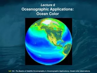
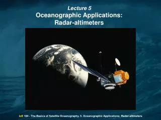
Lecture 5 Oceanographic Applications: Radar-altimeters. IoE 184 - The Basics of Satellite Oceanography. 5. Oceanographic Applications: Radar-altimeters. This lecture includes the following topics:. 1. Basic principles of satellite altimetry. 2. TOPEX/Poseidon satellite.

E N D
Lecture 5 Oceanographic Applications: Radar-altimeters IoE 184 - The Basics of Satellite Oceanography. 5. Oceanographic Applications: Radar-altimeters
This lecture includes the following topics: 1. Basic principles of satellite altimetry 2. TOPEX/Poseidon satellite 3. Sea Surface Height: Geoid Tides Geostrophic circulation 4. Sea Surface Roughness: Microwave scatterometer Synthetic Aperture Radar IoE 184 - The Basics of Satellite Oceanography. 5. Oceanographic Applications: Radar-altimeters
1. Basic principles of satellite altimetry Radar altimeters on board the satellite permanently transmit signals at high frequency (Topex-Poseidon - over 1700 pulses per second) to Earth, and receive the echo from the sea surface. This is analyzed to derive a precise measurement of the round-trip time between the satellite and the sea surface. The time measurement, scaled by the speed of light (at which electromagnetic waves travel), yields a measurement of the satellite-to-ocean range. IoE 184 - The Basics of Satellite Oceanography. 5. Oceanographic Applications: Radar-altimeters
1. Basic principles of satellite altimetry Each signal pulse produced by a radar altimeter consists of coherent electromagnetic energy. Receiving the echo signal, the sensor measures not only the amplitude but also the phase of the reflected signal and the travel time of the pulse. Measuring the phase of the signal reflected from the earth surface enables measuring the travel time with very high accuracy. IoE 184 - The Basics of Satellite Oceanography. 5. Oceanographic Applications: Radar-altimeters
1. Basic principles of satellite altimetry As electromagnetic waves travel through the atmosphere, they can be decelerated by water vapor or by ionization. Once these phenomena are corrected for, the final range R is estimated within 2 cm. The ultimate aim is to measure the sea level. This requires independent measurements of the satellite orbital trajectory, i.e. exact latitude, longitude and altitude coordinates. IoE 184 - The Basics of Satellite Oceanography. 5. Oceanographic Applications: Radar-altimeters
1. Basic principles of satellite altimetry Interaction of the pulse of duration τ with a smooth sea surface. For an altimeter in a 1000-km orbit a pulse duration of about 3 ns would lead to a footprint of diameter 2.8 km. IoE 184 - The Basics of Satellite Oceanography. 5. Oceanographic Applications: Radar-altimeters
1. Basic principles of satellite altimetry In practice sea surface is rough rather than flat. As a result, the first reflection of energy commences when the leading edge of the pulse reaches the topmost crests of the waves, earlier than for the flat surface, but the reflected energy does not achieve its maximum until the trailing edge reaches the lowest wave trough. In this way, the altimeter is able to average out the effect of the ocean waves. This parameter is called aSignificant Wave Height (SWH) IoE 184 - The Basics of Satellite Oceanography. 5. Oceanographic Applications: Radar-altimeters
1. Basic principles of satellite altimetry As a result of random distribution of the ocean wave facets at any instant, each individual return signal is very noisy, but averaging many successive pulses can reduce this. IoE 184 - The Basics of Satellite Oceanography. 5. Oceanographic Applications: Radar-altimeters
1. Basic principles of satellite altimetry • Of all sensors carried on satellites, the altimeter is most dependent upon its orbit to be capable of successful calibration and interpretation. • An altitude over 1300 km is advised, because: • the atmospheric drag there is an order of magnitude less than at 800 km; • ground stations can much better track the satellite; • the satellite orbit error resulting from irregularities of the Earth gravitation field at a high orbit is less than at a lower one. Different inclination results in different repeat cycles and track separation: Topex/Poseidon (10 days/316 km at equator) vs. Seasat (3 days/800 km). IoE 184 - The Basics of Satellite Oceanography. 5. Oceanographic Applications: Radar-altimeters
1. Basic principles of satellite altimetry Selecting a proper inclination, we should take into account that the precession of satellite orbit should not coincide with the harmonics of tidal cycle. As a result, Topex / Poseidon and Jason-1 satellites have altitude 1300 km and inclination 66º. IoE 184 - The Basics of Satellite Oceanography. 5. Oceanographic Applications: Radar-altimeters
2. TOPEX/Poseidon satellite TOPEX/Poseidon is a result of cooperation between the NASA (National Aeronautics and Space Administration) and the CNES (France's space agency, the Centre National d'Etudes Spatiales) IoE 184 - The Basics of Satellite Oceanography. 5. Oceanographic Applications: Radar-altimeters
2. TOPEX/Poseidon satellite TOPEX/Poseidon is based on three earlier earth-orbiting satellite missions. 1. GEOS-3 was launched in 1975. Its altimetric system measured sea level with a precision of approximately 20 centimeters and an accuracy of better than 50 centimeters. 2. SEASAT was launched in 1978. It measured the sea level with a precision of 10 centimeters at an accuracy of better than 30 centimeters. Unfortunately, the mission ended prematurely after about 100 days of operation. 3. GEOSAT was launched in 1985. Its accuracy and precision were comparable to SEASAT. The mission lasted for approximately 4 years. IoE 184 - The Basics of Satellite Oceanography. 5. Oceanographic Applications: Radar-altimeters
2. TOPEX/Poseidon satellite In 1979, NASA's Jet Propulsion Laboratory began planning TOPEX, an Ocean Topography Experiment that would use a satellite altimeter to measure the surface of the world's oceans. At the same time the French space agency CNES was designing an oceanographic mission called Poseidon, named for the Greek god of the sea. The two space agencies decided on a cooperative effort and pooled their resources to form a single mission. IoE 184 - The Basics of Satellite Oceanography. 5. Oceanographic Applications: Radar-altimeters
2. TOPEX/Poseidon satellite The Ariane 42P carrying the TOPEX/Poseidon spacecraft was launched from the European Space Agency's Guiana Space Center in Kourou, French Guiana, on August 10, 1992. Mass (kilograms) with dry/full tanks: 2169.4 / 2388.4 Dimensions (meters): length: 5.5 / span: 11.5 / height: 6.6 Solar Array: size: 29.4 sq. meters; power output (watts): 3385 (at start); 2100 (at 5 years) Data Storage: type: 3 tape recorders, 500 Mb each; record rate: 16 kb/s IoE 184 - The Basics of Satellite Oceanography. 5. Oceanographic Applications: Radar-altimeters
2. TOPEX/Poseidon satellite The TOPEX/Poseidon spacecraft uses a high-precision radar altimeter to take measurements of sea-surface height over 90% of the world's ice-free oceans. The satellite orbits at an altitude of 1336 kilometers above the earth at an inclination of 66 degrees. In approximately 10 days TOPEX/Poseidon completes 127 orbits. IoE 184 - The Basics of Satellite Oceanography. 5. Oceanographic Applications: Radar-altimeters
2. TOPEX/Poseidon satellite The satellite cycles consist of 127 orbits each. The 128th orbit repeats the 1st one, etc. IoE 184 - The Basics of Satellite Oceanography. 5. Oceanographic Applications: Radar-altimeters
2. TOPEX/Poseidon satellite TOPEX/Poseidon carries improved instrumentation and has the most accurate precision orbit determination of any earth-orbiting satellite. Its altimeter has a measurement precision of approximately 2.5 centimeters. After correction the resulting sea level observations are accurate to 5 centimeters. IoE 184 - The Basics of Satellite Oceanography. 5. Oceanographic Applications: Radar-altimeters
2. TOPEX/Poseidon satellite View from above satellite View from above orbital plane IoE 184 - The Basics of Satellite Oceanography. 5. Oceanographic Applications: Radar-altimeters
2. TOPEX/Poseidon satellite Repeat period = 9.915624999999977 DAYS = 856710 seconds CYCLE 1 267 48888.1516204 WED 1992-SEP-23 3:38 CYCLE 2 277 48898.0672454 SAT 1992-OCT- 3 1:36 CYCLE 3 286 48907.9828704 MON 1992-OCT-12 23:35 CYCLE 4 296 48917.8984954 THU 1992-OCT-22 21:33, etc. IoE 184 - The Basics of Satellite Oceanography. 5. Oceanographic Applications: Radar-altimeters
2. TOPEX/Poseidon satellite TOPEX/Poseidon's primary instrument for measuring ocean topography is an altimeter, measuring the distance between the satellite and the ocean surface. Air, water vapor, clouds, and rain slow down the return of the microwave signal. A second instrument called a radiometer is used to correct for the influence of water in the atmosphere. IoE 184 - The Basics of Satellite Oceanography. 5. Oceanographic Applications: Radar-altimeters
2. TOPEX/Poseidon satellite TOPEX/Poseidon carries two radar-altimeters: The dual-frequency NASA radar altimeter is the primary instrument aboard the spacecraft. It works by sending radio pulses at 13.6 GHz and 5.3 GHz toward the earth and measuring the characteristics of the echo. By combining this measurement with data from the microwave radiometer and with other information from the spacecraft and the ground, scientists can calculate the height of the sea surface. The single-frequency CNES altimeter is classified as an experimental sensor because TOPEX/Poseidon is the first flight to utilize this technology. The CNES altimeter is a low-power, low-mass sensor which works in much the same way as the NASA altimeter. Its precision is also comparable with that of the NASA altimeter. IoE 184 - The Basics of Satellite Oceanography. 5. Oceanographic Applications: Radar-altimeters
2. TOPEX/Poseidon satellite The altimeter measurement obtained by TOPEX/Poseidon would not be very useful if the satellite's position in space were not well known. Three different systems measure with unprecedented accuracy the position of TOPEX/Poseidon in space. Data from the SLR (Satellite Laser Ranging) and DORIS (Doppler Orbitography and Radiopositioning Integrated by Satellite) systems are used to determine the orbit of TOPEX/Poseidon. Together these systems provide all-weather, global tracking of the satellite. There are however, some limitations in land-based systems. IoE 184 - The Basics of Satellite Oceanography. 5. Oceanographic Applications: Radar-altimeters
2. TOPEX/Poseidon satellite To develop more accurate and less expensive methods of calculating orbits, the project installed a Global Positioning System or GPS receiver on the spacecraft as a flight experiment. The experiment proved a great success. During testing the GPS receiver simultaneously tracked signals from as many as 8 of the 21 GPS satellites that orbit the earth and provided the spacecraft's radial position with an accuracy of better than 3 centimeters. IoE 184 - The Basics of Satellite Oceanography. 5. Oceanographic Applications: Radar-altimeters
2. TOPEX/Poseidon satellite Free electrons are present in the earth's ionosphere. As with water vapor, these electrons delay the return of the radar pulse from the altimeter and thus interfere with the accuracy of sea-level measurements. To correct for this delay the altimeter takes measurements at two radio frequencies. The difference between the two measurements provides both a measure of the electron content and a correction for the range delay. IoE 184 - The Basics of Satellite Oceanography. 5. Oceanographic Applications: Radar-altimeters
2. TOPEX/Poseidon satellite In addition to TOPEX/Poseidon satellite, in December 7 2001 Jason-1, another satellite with radar-altimeter, was launched. Jason-1 is much smaller that TOPEX/Poseidon (weight 500 kg vs. 2400). All other characteristics of Jason-1 are similar to TOPEX/Poseidon. IoE 184 - The Basics of Satellite Oceanography. 5. Oceanographic Applications: Radar-altimeters
3. Sea Surface Height Sea Surface Height, i.e., the distance between the satellite and the ocean surface, depends on five principle factors: 3.1. Geoid 3.2. Ocean Tides 3.3. Atmospheric pressure 3.4. Geostrophic circulation 3.5. Ocean waves IoE 184 - The Basics of Satellite Oceanography. 5. Oceanographic Applications: Radar-altimeters
3. Sea Surface Height: Geoid We describe the Earth as an ellipsoid; however, in practice it is not an ellipsoid and the distribution of the mass within the Earth is not uniform. The resulting gravitation field of the Earth is also not uniform. These subtle variations of the gravitation field influence both the ocean surface and the satellite orbit. IoE 184 - The Basics of Satellite Oceanography. 5. Oceanographic Applications: Radar-altimeters
3. Sea Surface Height: Geoid The deviations of the geoid from the reference ellipsoid range from -104 m to +64 m. In areas where there are ocean trenches or ridges the geoid height can vary by several meters over a few kilometers. At present the shape of geoid is not known. Measuring the distance between the satellite and the Earth surface we can estimate the influence of the gravitation field over land, but not over the ocean. Therefore, sea surface height is referenced to geoid. In practice we operate the deviations from the sea surface averaged over several years of observations. IoE 184 - The Basics of Satellite Oceanography. 5. Oceanographic Applications: Radar-altimeters
3. Sea Surface Height: Ocean Tides Tides are periodic short-term changes in the height of the ocean surface caused by a combination of the gravitational force of the moon and the sun and the motion of the Earth. When the directions of the moon and sun gravitation coincide (full moon or new moon), the tidal range is maximum (spring tide, above). When the direction of the sun gravitation is perpendicular to the moon gravitation (first quarter of third quarter), the tidal range is minimum (neap tide, below). IoE 184 - The Basics of Satellite Oceanography. 5. Oceanographic Applications: Radar-altimeters
3. Sea Surface Height: Ocean Tides Maximum tidal range is up to 15 m (the Bay of Fundy near Moncton, New Brunswick, Canada. Tides can be estimated from mathematical models and removed from the altimetric measurements. Altimetric measurements provided a comprehensive information on tidal cycles. IoE 184 - The Basics of Satellite Oceanography. 5. Oceanographic Applications: Radar-altimeters
3. Sea Surface Height: Geostrophic circulation Sea Surface Height estimated after removal of tidal variability is attributed to steric height resulting from the differences in the ocean column density. From the horizontal gradients of steric height we can estimate geostrophic circulation. IoE 184 - The Basics of Satellite Oceanography. 5. Oceanographic Applications: Radar-altimeters
3. Sea Surface Height: Geostrophic circulation In practice we cannot obtain from altimetry the estimations of steric height because instead of geoid we operate mean ocean surface which includes both geoid and the elements of steady ocean circulation. The most productive way of analysis of sea surface topography is mathematical modeling with data assimilation. IoE 184 - The Basics of Satellite Oceanography. 5. Oceanographic Applications: Radar-altimeters
3. Sea Surface Height Hurricane Rita in the Gulf of Mexico. Elevated SSH demonstrates warm water “heating” the hurricane. IoE 184 - The Basics of Satellite Oceanography. 5. Oceanographic Applications: Radar-altimeters
3. Sea Surface Height: Ocean waves Ocean waves influence the signal received by the altimeter. The time during which the returned signal achieves its maximum indicates the significant wave height (SWH). IoE 184 - The Basics of Satellite Oceanography. 5. Oceanographic Applications: Radar-altimeters
3. Sea Surface Height The data collected by TOPEX/Poseidon and Jason-1 can be obtained from FPT sites: ftp://podaac.jpl.nasa.gov/pub/sea_surface_height//topex_poseidon/ /tp_ssha/ or ftp://podaac.jpl.nasa.gov/pub/sea_surface_height/jason/j1_ssha/ The data site contains folders starting from C011 (for TOPEX/Poseidon) or C001 (for Jason-1). Each folder contains the data collected during the 10-day period. Each period consists of 254 data files with one half-orbit each. Each orbital track has its number. IoE 184 - The Basics of Satellite Oceanography. 5. Oceanographic Applications: Radar-altimeters
3. Sea Surface Height The TOPEX/Poseidon truck numbers off southern California IoE 184 - The Basics of Satellite Oceanography. 5. Oceanographic Applications: Radar-altimeters
3. Sea Surface Height Each file contains binary data: Days from reference date(days) Milliseconds within the day (milliseconds) Geodetic Latitude (microdeg) Geodetic Longitude (microdeg) Sea Surface Height Anomaly (10-4 meter) Ku Significant Wave Height (mm) Inverse Barometer (10-4 meter) Ku Backscatter Coefficient (10-2 dB) Total Electron Content (TECU = 1016 electrons/square meter) Ocean Depth meter Mean Sea Surface (10-4 meter) IoE 184 - The Basics of Satellite Oceanography. 5. Oceanographic Applications: Radar-altimeters
3. Sea Surface Height The pattern of ocean circulation in the Southern California Bight. IoE 184 - The Basics of Satellite Oceanography. 5. Oceanographic Applications: Radar-altimeters
3. Sea Surface Height Example of sea surface topography dynamics off California. IoE 184 - The Basics of Satellite Oceanography. 5. Oceanographic Applications: Radar-altimeters
4. Sea Surface Roughness - Oblique-viewing microwave radiometers Microwave scatterometer is based on the principle of the resonant Bragg scattering. For a smooth surface, oblique viewing of the surface with active radar yields virtually no return. If the surface is rough, significant backscatter occurs. IoE 184 - The Basics of Satellite Oceanography. 5. Oceanographic Applications: Radar-altimeters
4. Sea Surface Roughness - Oblique-viewing microwave radiometers The interference of scattering from many different parts of the surface results in a reinforcement of scattering from periodic structures in the surface roughness which have suitable wave lengths, and destructive interference of all other reflections. IoE 184 - The Basics of Satellite Oceanography. 5. Oceanographic Applications: Radar-altimeters
4. Sea Surface Roughness - Oblique-viewing microwave radiometers SeaWinds scatterometer contains the antenna spinning at a rate of 18 rpm about a vertical axis. The electromagnetic pulses are bounced at incidence angles of 46º (HH-polarized) and 54º (VV-polarized). The footprint circles have diameters of 1400 km (HH) and 1800 km (VV). The IFOV for each beam is ~30x40 km.During one antenna revolution the satellite moves ~22 km along the orbit. IoE 184 - The Basics of Satellite Oceanography. 5. Oceanographic Applications: Radar-altimeters
4. Sea Surface Roughness - Oblique-viewing microwave radiometers Tropical cyclone observed by QuikSCAT in June 2007. IoE 184 - The Basics of Satellite Oceanography. 5. Oceanographic Applications: Radar-altimeters
4. Sea Surface Roughness - Oblique-viewing microwave radiometers Santa Ana offshore wind in the Southern California Bight measured by QuikSCAT scatterometer. IoE 184 - The Basics of Satellite Oceanography. 5. Oceanographic Applications: Radar-altimeters
4. Sea Surface Roughness - Oblique-viewing microwave radiometers The example of wind speed over the ocean surface measured by QuikSCAT scatterometer. IoE 184 - The Basics of Satellite Oceanography. 5. Oceanographic Applications: Radar-altimeters
4. Sea Surface Roughness - Oblique-viewing microwave radiometers Synthetic aperture radar (SAR)is based on the comprehensive analysis of contribution from individual points to the signal received when the sensor is at a particular point. The result is very high resolution. IoE 184 - The Basics of Satellite Oceanography. 5. Oceanographic Applications: Radar-altimeters
4. Sea Surface Roughness - Oblique-viewing microwave radiometers A sophisticated computer-based analysis of the differences between the pixels of the images observed from different positions results in very high spatial resolution. SAR provides information on small and mesoscale circulation structures, oil slicks, sea ice, etc. IoE 184 - The Basics of Satellite Oceanography. 5. Oceanographic Applications: Radar-altimeters
4. Sea Surface Roughness - Oblique-viewing microwave radiometers This SAR image shows mesoscale eddies in the Santa Barbara Channel. IoE 184 - The Basics of Satellite Oceanography. 5. Oceanographic Applications: Radar-altimeters
4. Sea Surface Roughness - Oblique-viewing microwave radiometers The difference in the color of the surface indicate the difference in its roughness. Compare smooth surface in the near-shore zone with rough surface offshore. IoE 184 - The Basics of Satellite Oceanography. 5. Oceanographic Applications: Radar-altimeters
4. Sea Surface Roughness - Oblique-viewing microwave radiometers These SAR images show ice formation (left) and cyclonic eddies at the edge of ice pack in the Weddell Sea in Antarctica. IoE 184 - The Basics of Satellite Oceanography. 5. Oceanographic Applications: Radar-altimeters