Marine Digimap
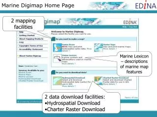
Marine Digimap. marine datasets provided by SeaZone Solutions, part of the UK Hydrographic Office View, annotate and print maps, download SeaZone Hydrospatial and Charted Raster data for use in GIS. Login to Digimap from the front page.

Marine Digimap
E N D
Presentation Transcript
Marine Digimap marine datasets provided by SeaZone Solutions, part of the UK Hydrographic Office View, annotate and print maps, download SeaZoneHydrospatial and Charted Raster data for use in GIS
Selectthe first menu option, then choose Marine Roam Select Marine
You must agree to the terms of use before gaining access to Marine Digimap.
Map Tools: Annotate Measure Move around: zoom and pan Task Menu: Overview map Map Content Control Map Info Map panel
Search Search for a location by place name, grid reference, coordinates, or by clicking on the map.
Search by overview map Extensive Help Pages are available.. Search by Overview Map
Navigation • Zoom slider • Use to zoom in/out • Zoom to area - Use to click and drag on the map • Pan • Click and drag the map • Click the relevant arrow to pan the map in that direction. • Full extent / Previous / Next views
Map Content The Map Content tab on the left in the left panel contains a list of the marine features that are included in the map you are currently viewing. Switch features off and on by checking or un-checking the tick box next to the feature. Control visible map content
Map Information Map Information enables dynamic updates to the display. Panning and zooming will change the information shown.
My Maps • Click Save – My Map • Enter a title • Click Save • Click Open to view saved maps • Select a map to view or to delete
Annotations Tools Extensive Help Pages are available.. Annotation Tools Add lines, shapes, text and labels to your map
Annotation Tools • Toolbar appears at the top of the screen – can be moved around • Main options to add annotations in the Draw & Create area: • Add symbols, text, lines, polygons, pre-defined shapes • Annotations remain on your map at the same scale as you zoom • Annotations appear on your print maps
MeasurementTools Measurement Tools Measure distance and area.
Feature information tool Click the tool, then click on the map to identify features.
Print Generate a file for printing Takes you to a print window where you can create A4 to A0 files to print
Print • add map title, choose print format • option to include annotations, national gridlines • move map around in preview • add legend
Marine Maps Marine Maps allows you to create a map from one of six predefined scale bands based on SeaZone's Charted Raster product. The maps in each scale band can be zoomed in and out to best display the selected area. Select Marine then choose Marine Maps
Hydrospatial Download • Hydrospatial Download allows you to select and download data. • This vector dataset contains many different layers covering the various groups of features found on marine maps. • download in Shapefile or MapInfo formats • select feature layers within the data product Selectthe second menu option, then choose Hydrospatial Download Select Marine
Choose a file type from the product you want to download. Then click to continue.
The Search tab of the interface provides a range of methods for finding your area of interest. If you know the position of your location you can also click on the map.
Choose your archiving and compression then begin downloading by clicking on Extract Data
Check the download status by clicking on the link shown above. The data is ready when you click the link and the page changes to the one below.You can then download the data to your computer or storage device.
Contact EDINA Geosupport if you need any help using Marine Digimap edina@ed.ac.uk 0131 650 3302