Download
1 / 43
430 likes | 614 Vues
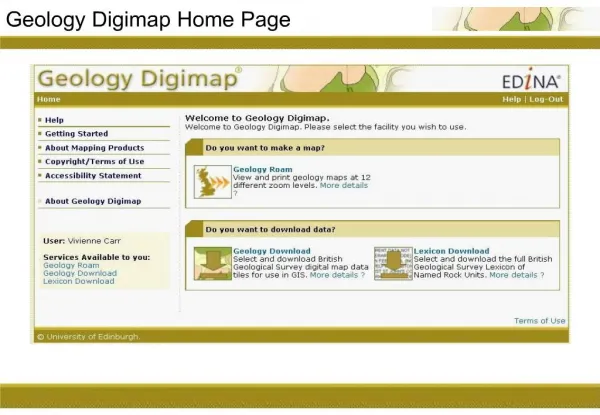
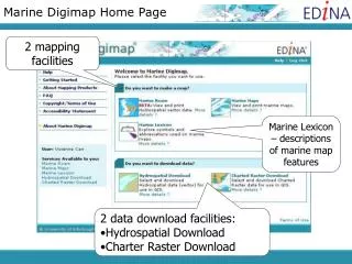
Marine Digimap Home Page. 2 mapping facilities. Marine Lexicon – descriptions of marine map features. 2 data download facilities: Hydrospatial Download Charter Raster Download. Marine Digimap. Marine Maps Marine Roam Charted Raster Download Hydrospatial Download. Marine Maps.

E N D
Marine Digimap Home Page 2 mapping facilities Marine Lexicon – descriptions of marine map features • 2 data download facilities: • Hydrospatial Download • Charter Raster Download
Marine Digimap • Marine Maps • Marine Roam • Charted Raster Download • Hydrospatial Download
Marine Maps • Maps can be viewed on screen or printed/downloaded at A4. • Source data - maps are created from scanned Admiralty Chart images, covering the UK and the surrounding seas. • The maps are grouped into 6 scale bands; ocean, sea, general, coastal, approaches and harbour (roughly equivalent to the usage bands of Admiralty Charts). • Each scale band features a different set of Admiralty Charts, with features most relevant to the scale. The scanned images are used to build up a mosaic of maps for each scale band. • Scales vary from 1:3.5million to 1:2,500. • These make ideal backdrop maps, but must NOT be used for navigation.
Scale/Usage bands • Ocean - small scale ( 1:3,500,000 to 1:750,000) • Sea - small scale (> 1:750,000 to 1:300,000) • General - small to mid scale (1:200,000 to 1:100,000) • Coastal - mid scale ( 1:100,000 to 1:50,000) • Approaches - mid to large scale ( 1:50,000 to 1:15,000) • Harbour - large scale ( 1:25,000 to 1:2,500)
Marine Maps • Source maps may be at different scales. • In Marine, maps are viewed at same scale so you may find some differences in detail in adjacent areas.
Marine Maps home page • Use the drop down menu to view areas covered by different usage bands. • To search, enter details in a search box or click on the map to go to your area of interest.
Location Map • Shows the wider area around your current area (red square). • Allows you to select and view the coverage of other usage bands, in that area. • Can pan around the location map by clicking and dragging the red square.
Different map views • Switch views by clicking on the icons above the map • Zoom in and out of that view, using the bar to the left of the map
Legend • The legend shows the more commonly found symbols on Marine Maps • More detailed information available from the Marine Lexicon
Map Chest • Maps can be saved in Map Chest • Unique to each user • Maps erased after 5 days • Print from Map Chest as: • PNG format • A4
Marine Digimap • Marine Maps • Marine Roam • Charted Raster Download • Hydrospatial Download
Introduction • Uses Hydrospatial Vector data (launched in 2005): http://www.seazone.com/hydrospatial.php • Data has 6 topic layers, each layer further broken down into themes. • ‘SeaZone Hydrospatial is in its infancy and is under continual development and improvement both in form, content and structure. Initially, much of the information that SeaZone Hydrospatial contains is re-engineered from data captured by UKHO from paper charts for the production of ENCs (Electronic Navigational Charts). Increasingly though, more will be based on improved source data sets (e.g. wrecks) and on totally new data sets (e.g. detailed bathymetry from digital surveys) that depict the real world environment and provide key base reference information to be established.’
Hydrospatial data • 8 topic layers
Marine Roam Task Menu: Search, customise, Print, Map Info, Save your map Navigation and zoom tools
Views • 13 fixed scale views, ranging from 1:2500 to 1:5,000,000 • Not all data layers can be viewed at each scale • Default view or ‘Basemap content view’ – contains a selection of layers from the data appropriate for that scale • Select layers of your choice for ‘Customised content view’
Customised content view • Check the boxes next to the topics and layers you wish to display
Overview Map • Click and drag red box to reposition your map location
Print • Click Continue to open new window
Print • If you have all layers selected, likely to receive an error message. • De-select some layers and try again.
Print • Reposition map by clicking and dragging preview map. • Set title, grid lines options. • Select portrait/landscape, A3/A4. • Click Generate Print File.
Map Information • Displays: • coordinates of current map, • print scale, and • cursor coordinates
MyMaps • Save up to 200 maps within MyMaps • Click any entry in the list to regenerate that map
Feature Info. • Click then on your feature on the map • Marker placed where you click
Marine Digimap • Marine Maps • Marine Roam • Charted Raster Download • Hydrospatial Download
Charted Raster data • Used in the Marine Maps facility. • Scanned Admiralty Charts covering the UK and the surrounding seas from 1:3.5million to 1:2,500. • The data is supplied as GeoTiff images, ready for use in a GIS. • Each map has its own projection, referenced to the Horizontal WGS84 Datum. • These data make ideal backdrop maps, but must NOT be used for navigation
Step 1: Search for location • Select the Scale bands of interest • use the coverage map to see which bands are available for your area • bands deselected can be added back in when choosing maps • Search using one of the options • Select your location from the list of results, if applicable
Step 2: Select maps • Choose the maps you want from the list or click on the map • Use the zoom and scale bands to see larger or smaller maps in the area • Click Continue
Step 3: Make settings • Option to take other sections of Multiple part maps • Previews of all maps available • Archiving and compression • Extra box to tick to confirm you are aware that charts are NOT for navigation • Click Extract Data
Step 4: Downloading • Click the link to go to the download page • Use your browser's ‘Save link as..’ or ‘Save target as..’ option
Marine Digimap • Marine Maps • Marine Roam • Charted Raster Download • Hydrospatial Download
Hydrospatial Data • This is a vector data product from SeaZone, designed for use in a GIS. • Available in 2 formats: • Shapefile (for ArcGIS) • MapInfo Tab • The data is collected at various scales, the best available for each source. • As vector data it is scale free when displayed. • The data is projected in WGS84 not British National Grid. • 7 data topics are available.
Hydrospatial Data 7 Topics: • Bathymetry & Elevation (BE) • Socio-Economic & Marine Use (SE) • Conservation & Environment (CE) • Natural & Physical Features (NP) • Structures & Obstructions (SO) • Climate & Oceanography (CO) • Metafeatures & Cartography (MC)
Hydrospatial Data • Each Topic has layers of detail. • Depending on the area selected for download, they may not all be available. • Example: • Structures and Obstructions • Navigation Aides • Obstructions • Offshore Installations • Shoreline Constructions • Wrecks
Hydrospatial Download • Hydrospatial download process: • Identify product / format • Search for your location • Select the required data • Make download settings • Download data
Step 1: Product/format • Select product/topic • Choose data format • Click Continue
Step 2: Search for location • Select a search method and input search terms • Choose a result from the list generated, where applicable
Step 3: Select data tiles • Choose the tiles you want from the list or map • Choose the required layers • Click Save layer selection • Click continue
Step 4: Make settings • Archiving and compression • Large numbers of component files mean no individual file downloads • Click Extract data
Step 5: Downloading • Use your browser's ‘Save link as..’ or ‘Save target as..’ option • Click the link to go to the download page
Onward use of data in ArcGIS Hydrospatial data: • Older versions of ArcGIS not supported. Can’t guarantee data will work in ArcView 3.x • Shape files, no need to convert • All of the files provided with Shape files must be kept in the same folder • For correct data display, need to download and install 2 folders: • fonts.zip • style.zip • both available in Help > Using data with ArcGIS