Download
1 / 28
280 likes | 426 Vues
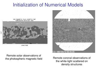
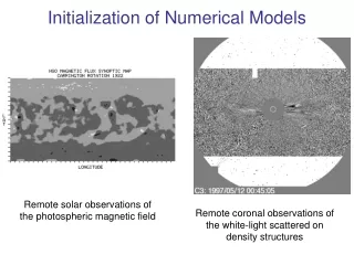
LAPS Initialization of Models for Numerical Weather Prediction. Isidora Jankov Modeling efforts related to HMT and simulations of MCSs.

E N D
LAPS Initialization of Models for Numerical Weather Prediction IsidoraJankov Modeling efforts related to HMT and simulations of MCSs Collaborators: Zoltan Toth, Tim Schneider, Dan Birkenheuer, Allen White, Martin Ralph, Steve Koch, Steve Albers, Huiling Yuan, Ed Tollerud, Tara Jansen, John Halley Gateway ESRL/PSD, NCAR/DTC, California DWR, NSSL, OHD, Western region WFOs and many others LAPS workshop Boulder, CO 25-27 October, 2010
HMT WEST - Cool Season HMT EAST – All Season, including Hurricane Landfall HMT CENTRAL – Warm Season HMT Overview • Goal is to improve forecasts of rain and snow and associated hydrology • Uses local-state-federal, and private-public-academic partnerships Benefits:Accelerates improvements in QPF and flood forecasting, with impacts on transportation, ecosystems, emergency management, flood control and water supply. Science and field tests will advise on how best to fill gaps in observational and modeling systems.
ATMOSPHERIC RIVERS • During the winter season significant precipitation events in California are often caused by land-falling “atmospheric rivers” associated with extra tropical cyclones in the Pacific. • Atmospheric rivers are elongated regions of high values of vertically integrated water vapor over the Pacific and Atlantic oceans that extend from the tropics and subtropics into the extratropics and are readily identifiable using SSM/I. • Due to the terrain steepness and soil characteristics in the area, a high risk of flooding and landslides is often associated with these events.
EXPERIMENT DESIGN 2009-2010 • Nested domain: • Outer/inner nest grid spacing 9 and 3 km, respectively. • 6-h cycles, 120hr forecasts foe the outer nest and 12hr forecasts for the inner nest • 9 members (listed in the following slide) • Mixed models, physics & perturbed boundary conditions from NCEP Global Ensemble • 2010-2011 season everything stays the same except initial condition perturbations?
CORRESPONDING LAPS ANALYSIS FOR BOTH OUTER AND INNER NEST Total Precipitable Water analyses
QPF Example of 24-h QPF 9-km resolution 9 members: ARW-TOM-GEP0 ARW-FER-GEP1 ARW-SCH-GEP2 ARW-TOM-GEP3 NMM-FER-GEP4 ARW-FER-GEP5 ARW-SCH-GEP6 ARW-TOM-GEP7 NMM-FER-GEP8
HMT QPF and PQPF 24-hr PQPF 48-hr forecast starting at 12 UTC, 18 January 2010 0.1 in. 1 in. 2 in.
Xsect Reflectivity 06 Oct. 2010 18UTC GEP2 GEP3 GEP4 GEP6 LAPS GEP1 GEP5 00 hr 03 hr 06 hr
Cycling Initial Perturbations –Link with DET Legend Perturbation Global Model Analysis interpolated on LAM grid Global Model Forecast LAM Forecast 00Z 06Z Forecast Time
Wind Speed July 30 2010 00UTC 00hr LAPS CYC NOCYC 03hr 06hr
Cloud Coverage July 30 2010 00UTC LAPS CYC NOCYC 00hr 03hr 06hr
Initial Perturbations for HMT-10/11 “Cycling” GEFS (or SREF) perturbations LAM forecast driven by global analysis Global Model Analysis interpolated on LAM grid Perturbations Perturbations adjusted toward LAPS 00Z 06Z 12Z Forecast Time
High resolution simulations of IHOP MCSs when using LAPS hot-start initialization
6-hr Diabatically (LAPS) initialized WRF-ARW forecast Analysis 13 June 2002
Analysis 3-hr Forecast 16 June 2002
850 mb Analyzed and Simulated Reflectivity Analysis 2hr HOT Fcst 2hr NO-HOT Fcst 16 June 2002
800mb Radar Reflectivity W is Windsor Tornado L is Laramie Tornado L W
00-03hr simulated reflectivity for 22 May 2005 initialized at 17 UTC
ETS and Bias averaged over 8 events for configurations using various convective parameterizations 00-06h LAPS IC NAM IC Jankov et al. 2007
DATA AND METHODOLOGY • Simulations of 8 International H2O Project (IHOP) MCS events were performed by using 12 km Weather Research and Forecasting (WRF) model with ARW dynamic core. • Both diabatic Local Analysis and Prediction System (LAPS) ‘hot’ startand 40km NAM analyses were used as initial conditions, while the boundary conditions were always from 40 km NAM output. • The simulations were performed for various combinations of Convective, Microphysics and PBL schemes. • The integrations were performed over the 24 hour period and over a limited domain of approximately 1500x1500 km.
Initial conditions were changed and the model configuration was kept the same ETS diff. 00-06 hr ETS diff. 12-18 hr IC- Initial Conditions (LAPS-Eta) PP- Physical Parameterization Red-95%, Dark blue-90%, Grey-80% Jankov et al. 2007