ADDRESS DATASET
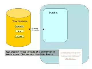
This dataset provides detailed address point information formatted as Shapefiles and SQL Server Tables. It includes address identification fields, mailing information, geographic coordinates, and maintenance responsibilities for various addresses within specific areas. Each address point features unique identifiers, formatted mailing addresses, and is linked to geographic property and tax property IDs, enhancing utility for geographic information system (GIS) applications and urban planning. Additional fields ensure accurate representation and upkeep of address data.

ADDRESS DATASET
E N D
Presentation Transcript
ADDRESS DATASET FILE FORMAT
FORMAT • Shapefile • Address Point – pub\addrep\shpfiles\addpt.shp • Maintenance Responsibility – pub\addrep\shpfiles\addptmrpoly.shp • SDE Feature Class • Address Point – jocogeog.dl.address_pt • Maintenance Responsibility – jocogeog.dl.addressmaintresp_pl
FORMAT Continued • SQL Server Table • Address Point – Addpt in addrep database • Includes additional fields: • SOUND – a soundex field • MailAddLine – the formatted mailing address • MailCityLine – the formatted city address line
FIELDS • APID (Text, 18) • The unique identifier for each address point. It was created as a Text field because a shapefile can not have more than 15 characters in a number field. • Format: yyyymmddhhnnssxxxx • 4 digit Year/2 digit month/2 digit day/2 digit hour/ 2 digit minute/ 2 digit second/4 digit random number • Num (Long Integer) • The address number.
FIELDS Continued • PreDir (Text, 2) • The prefix directional. • Valid Values: N,S,E,W • StrName (Text,40) • The name of the street.
FIELDS Continued • StrType (Text, 4) • The street suffix. • Valid Values: • AVE • BLVD • CIR • CT • DR • HWY • LN • PKWY • PL • RD • RDWY • ST • TER • WAY
FIELDS Continued • SecUnitDes (Text, 4) • The secondary unit designator. This is used to designate an apartment, etc. • Valid Values: • APT • BSMT • # (Default) • BLDG • DEPT • FL • FRONT • HNGR • KEY • LBBY • LOT • LOWR • OFC • PH • PIER • REAR • RM • SIDE • SLIP • SPC • STOP • STE • TRLR • UNIT • UPPR
FIELDS Continued • SecUnit (Text, 20) • The description of the secondary unit, i.e. the number, etc. • City (Text, 20) • This is the city value derived by a point in poly operation if the address falls within an incorporated area. If the address falls within an unincorporated area the city reflects the mailing city for that zip code. • State (Text, 2) • The state.
FIELDS Continued • Zip (Text, 10) • The zip code derived by a point in poly operation on zip feature class. • X (Long Integer) • The X state plane coordinate. • Y (Long Integer) • The Y state plane coordinate. • Alias (Text, 103) • A descriptive field about the address point. Mainly used to hold a common place name for the point. • MaintResp (Text, 30) • The organization in charge of maintaining the address points.
FIELDS Continued • GeoPropID (Text, 16) • The geographic property id. Derived from the GeoPropID found in the property polygon the address point coincides with. Every address point should have a GeoPropID in theory. • TaxPropID (Text, 16) • The taxing property id. Derived from the TaxPropID found in the property polygon the address point coincides with. Every address point except those found on untaxed property should have a unique TaxPropID associated with it. Address points falling on the same untaxed property polygon will all share the TaxPropID associated with that polygon.
FIELDS Continued • TxPIDConf (Text, 2) • A code used to signify the confidence in the match between the address in the point data and the property polygon it is associated with. • The code will have either an A (a single property polygon is associated with the point) or a B (more than one property polygon is associated with the point) and a number from 1 to 5 indicating the degree of confidence. • Valid Values: • A1 Single Polygon – Perfect Match • A2 Single Polygon – Apartment point with no matching apartment value • A3 Single Polygon – Only matching street number and street name • A4 Single Polygon – Only matching street number • A5 Single Polygon – No Match • B1 Multiple Polygon – Perfect Match • B2 Multiple Polygon – Apartment point with no matching apartment value • B3 Multiple Polygon – Only matching street number and street name • B4 Multiple Polygon – Only matching street number • B5 Multiple Polygon – No Match
AND NOW THE NUMBERS….(AS OF OCTOBER 15, 2003) • LEAWOOD – 11703 ADDRESSES • LENEXA – 21279 ADDRESSES • OLATHE – 47982 ADDRESSES • OVERLAND PARK – 76278 ADDRESSES • SHAWNEE – 22325 ADDRESSES • OTHER – 33016 ADDRESSES • TOTAL – 220496