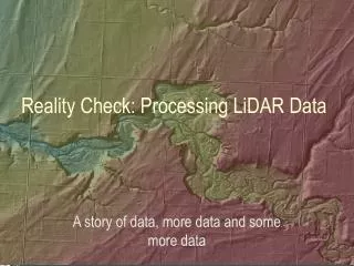
Processing Coastal Lidar Data
Andrea Ryan. Processing Coastal Lidar Data. Nueces River Delta. “Persistently high salinity concentrations severely inhibit[s] the function of the Nueces Delta” ( Dunton et al). Data Collection for Model. Lidar Data. Received Data – 1m x 1m grid. Find coordinate system!.


Processing Coastal Lidar Data
E N D
Presentation Transcript
Andrea Ryan Processing Coastal Lidar Data
Nueces River Delta • “Persistently high salinity concentrations severely inhibit[s] the function of the Nueces Delta” (Dunton et al). • Data Collection for Model
Lidar Data • Received Data – 1m x 1m grid Find coordinate system!
Rotating the Raster • Why rotate the raster? N 1m x 1m grids
Larger Grid Size 100m x 100m grids
Topography vs. Bathymetry Topography: Bathymetry: elevation data datum datum depth to sea floor *Datum is according to NAVD88 in this case *Datum is water level
Combining Topo-Bathy The entire area is so flat it is difficult to tell where it is surface water & where it is land
Coastal Lidar Mapping Applications Workshop • San Antonio: November 15th & 16th 2009. • Issues with specular reflection on marshy areas • Issues with wet/dry delineation • Issues with MetaData & QA/QC
TCOON Data Texas Coastal Ocean Observation Network • Associate Time Series for: • Water levels • Wind Speeds • Wind Directions
Future Work • Collect salinity data from TCOON • Collect streamflow data from USGS • Meet with UT Center for Space Research
References • http://lighthouse.tamucc.edu/TCOON • Kenneth, Dunton H., Montagna A. Paul, Ward H. George, and Whitledge E. Terry. Rincon Bayou Demonstration Project. Rep. Vol. I. Austin: Bureau of Reclamation, TX. Print. • maps.google.com • NRC, Mapping the Zone: Improving Flood Mapping Accuracy, The National Academies Press. Washington, D.C. • www.srh.noaa.gov/rcfshare/precip_download.php
11/24/2009 Questions?