Download
1 / 64
700 likes | 1.94k Vues
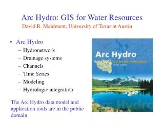
Arc Hydro Hydronetwork Drainage systems Channels Time Series Modeling Hydrologic integration. Arc Hydro: GIS for Water Resources. David R. Maidment, University of Texas at Austin. The Arc Hydro data model and application tools are in the public domain.

E N D
Arc Hydro Hydronetwork Drainage systems Channels Time Series Modeling Hydrologic integration Arc Hydro: GIS for Water Resources David R. Maidment, University of Texas at Austin The Arc Hydro data model and application tools are in the public domain
Bringing together these two communities by using a common geospatial data model Arc Hydro design took 3 years from 1999 - 2002 CRWR GIS CRWR GIS in Water Resources Consortium Water Resources
Hydrologic Information System Analysis, Modeling, Decision Making Arc Hydro Geodatabase
Geographic Data Model • Conceptual Model – a set of concepts that describe a subject and allow reasoning about it • Mathematical Model – a conceptual model expressed in equations • Data Model – a conceptual model expressed in a data structure • Geographic Data Model – a data model for describing and reasoning about the world
What is Arc Hydro? • A geographic data model for storing geospatial and temporal water resources data in ArcGIS • A set of hydro objects built on top of ArcObjects • A set of standardized attributes • A vocabulary for describing data (glossary) • A toolset for implementing the data model
Drainage System Hydro Network Flow Time Time Series Hydrography Channel System Arc Hydro Data Model
ArcGIS Hydro Data Model Hydrology Hydrography
Data Model Based on Inventory Streams Drainage Areas Hydrography Channels Terrain Surfaces Rainfall Response Digital Orthophotos
Data Model Based on Behavior Follow a drop of water from where it falls on the land, to the stream, and all the way to the ocean.
Integrating Data Inventory using a Behavioral Model Relationships between objects linked by tracing path of water movement
Arc Hydro Framework Input Data Watersheds Waterbody Streams Monitoring Points
National Hydro Data Programshttp://www.crwr.utexas.edu/giswr/nhdconf/nationalhydro.html National Elevation Dataset (NED) National Hydrography Dataset (NHD) Elevation Derivatives for National Application (EDNA) Watershed Boundary Dataset
HydroNetwork through Canyon Lake Flowlines through water body Generic Junction (for topological connection of edges)
Network Tracing Upstream Tracing Downstream Tracing
Watersheds of the Guadalupe Basin NWS forecast Watersheds (flooding) Guadalupe HydroNetwork EPA TMDL Segments (water quality) TNRCC water availability points (water supply)
Scales of representation of Drainage Systems Basins – drainage areas for water resources management Watersheds – subdivision of Basin for a particular hydrologic purpose Catchments – subdivision of Basin into elementary drainage areas by physical rules Digital Elevation Model – land surface terrain grid cells
Direction of Flow Channel Cross-Section Channel Cross-Section
Guadalupe Network Study area only 1.4 km!
Study Area (Guadalupe river near Seguin, TX) 1/2 meter Digital Ortho Photography
Depth Sounder (Echo Sounder) The electronic depth sounder operates in a similar way to radar It sends out an electronic pulse which echoes back from the bed. The echo is timed electronically and transposed into a reading of the depth of water.
Differential GPS: Bank to Boat GPS gives the location of each point collected in terms of latitude and longitude. Two locations for differential GPS.
Channel Data Each point has (x,y,z)
Interpolation Points are interpolated in ArcMap to produce a continuous surface.
Centerline Define the centerline along the thalweg of the channel
Measure in ArcGIS Measures are assigned in meters 154.41 54.37 0 281.36 A PolylineM can store m-values at each vertex along with x and y coordinates.
Coordinate Transformation m is measure along the centerline r is distance across the river from the centerline Sinuous river becomes straight when transformed into (m,r) co-ordinates.
Coordinate Transformation Straightened river Profile line and cross-sections Sinuous river
Data back to x,y coordinates Profile lines and cross-sections in (x,y) created using FishNet in (m,r). Original river in X,Y
Profile Lines and Cross Sections in 3D Bird’s eye view!
Arc Hydro Time Series Object TSDateTime TSValue FeatureID TSType
National Water Information System Arc Hydro NWIS data retrieval tool Web access to USGS water resources data
Retrieving NWIS Data • Select Gage Layer • Enter Period of Record
Streamflow Time Series Arc Hydro Time Series Table
Time Series Extracted to Excel(In Excel, use Data/Get External Data to query Geodatabase) Excel view Geodatabase view
Real-time Nexrad data supplied every 15 minutes on a 2km grid Data from 14 radars calibrated with 435 rain gages At end of month more careful calibration is done for historical rain map archive Nexrad Data for Florida