Download
1 / 14
140 likes | 271 Vues
In recent discussions, we've envisioned a cohesive strategy for enhancing hydrodata accessibility and relevance. By leveraging tools like Arc Hydro on the web, we can develop comprehensive modeling and operational layers that synthesize hydro features globally. Our goal is to facilitate thoughtful planning in the context of aquatic biology, flooding, and river network management, engaging billions of application users and millions of GIS professionals. Let's explore solutions that make water-related data accessible and useful for society's needs, while promoting a deeper understanding of our waterways.

E N D
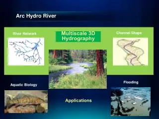
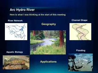
Arc Hydro River Here is what I was thinking at the start of this meeting Geography Applications Channel Shape River Network Flooding Aquatic Biology
Is Global Geospatial Consciousness Possible? We’ve discussed this a lot over the past couple of days There are lots of things that could be done …… ……. we need a thoughtful plan Society Billions Application Users Millions GIS Professionals 100’s of Thousands Research Thousands
Global Topographic Basemap in ArcGIS.com Tiled base map synthesizing information across map scales World United States Texas Austin Home How do we do this for hydro?
Arc Hydro on the Web A vision has emerged at this meeting ….. Modeling Layers Descriptive Layers Observations Layers Operational Layer (Key Hydro Functions) Display Layer (Base Map)
Hydro BaseMapDisplay Layer The Hydrography or “blue line” component of a topographic map
Hydro Operational Layer A geometric network with a local catchment for each network edge
Hydro Observation Layers Time-enabled feature layers of observations data
Hydro Descriptive Layers Static information about hydro features ……Linked to the Operational Layer by “Virtual Referencing” Groundwater divides Watershed divide Fish species distributions 100 year flood depth Groundwater divide High Water Marks
Hydro Modeling Layers Models that connect maps Source: USGS Water Census
Global HydroBase Map and Operational Layer Build from HydroSheds Start Global and use this to define the template
HydroSheds for the World The data is already presented in ArcGIS.com
Arc Hydro on the Web Within the US, lets explore a “Map Sandwich” as a stack of services Modeling Layer Services Descriptive Layer Services Observations Layer Services Operational Layer Services (Key Hydro Functions) Display Layer Services (Base Map)
Is Global Geospatial Consciousness Possible? How to make this work for Hydro Make geospatial understanding of water relevant by making it accessible and easy. Think of the questions people might want of ask of the data. Society Billions Application Users Millions DreamBig GIS Professionals 100’s of Thousands Key Expansion Arc Hydro Today Research Thousands
New LiDAR Workflow • Direct use of LAS files • On the fly mosaicking and rendering (hillshade, slope, etc) • Input to analytic tools as a raster or terrain • Editing • Research hydrologic derivatives from high resolution triangulated elevation LAS LAS LAS LAS LAS LAS LAS LAS LAS LAS LAS LAS LAS LAS