Geospatial Data Layers for Arc Hydro River
This document outlines the findings and vision discussed during the Arc Hydro River meeting at the Clark Siler Center for Research in Water Resources at the University of Texas, Austin, on December 1, 2010. It covers historical insights from Texas Senate Bills on water management, introduces the Water Rights Analysis Package (WRAP) as a geospatial model, and poses several research questions regarding the future of hydrologic data and its applications. The aim is to build a simpler, sustainable system for managing water resources effectively.
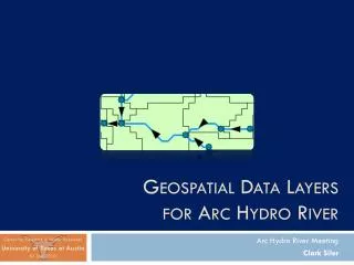

Geospatial Data Layers for Arc Hydro River
E N D
Presentation Transcript
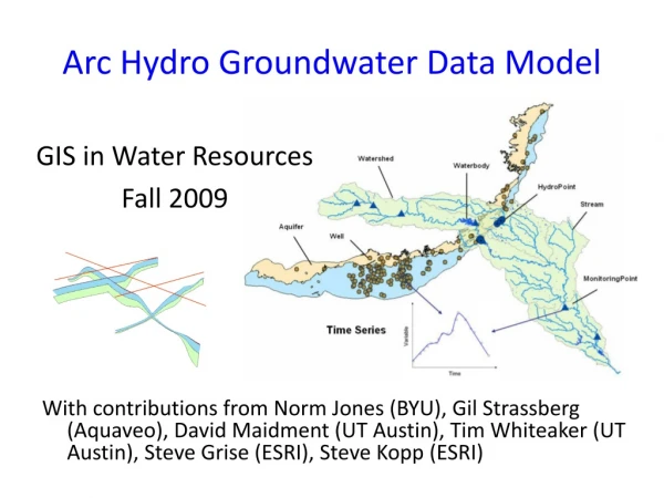
Geospatial Data Layers for Arc Hydro River Arc Hydro River Meeting Clark Siler Center for Research in Water Resources University of Texas at Austin 01 Dec 2010
Outline • Review • Vision • Research Questions • Q1: History • Q2: Future • Q3: Network Applications • Summary • Indicators of Completion
Review – Texas’ Senate Bills • Senate Bill 1 (1997) • Established Texas’ Official WAM • Senate Bill 2 (2001) • Instream Flows “…establish and continuously maintain an instream flow data collection and evaluation program….” • Senate Bill 3 (2007) • Environmental Flows Allocation Process How much water do rivers and bays need to stay healthy?
Review – WRAP & WAM • WRAP – Water Rights Analysis Package • Suite of programs to digitally manage water rights in Texas • Developed by Dr. Ralph Wurbs of the Texas Water Resources Institute at Texas A&M • 23 basins, 10,000 locations, 50 years • Texas’ official Water Availability Model • Response to drought of 1996 (SB1) • Includes WRAP model & input datasets
Review – WRAP • WRAP as a Hydrologic Geospatial Model WRAP Input Files Model Output Sensitive to Change
Review – WRAP Display Each space-time point is unique and is associated with a set of variables Space Time A set of variables… Graphs Time Maps Hard-coded Space
Review – WRAP Network Tools Layers related, but network was modified manually Spatially-aware tools on a network
Review – Flow Regimes IHA MBFIT Data and analyses singly-contained for easy sharing Not connected to GIS
Review – Barriers & Goal • Three Barriers Encountered • Adaptable geospatial model • WRAP Display • Underlying network for analyses • WRAP Network Tools • Web inclusion and sharing of analyses • Flow Regimes Work • Goal: Build a simpler, more sustainable system
Review – DEMs & Catchments • Much of hydrologic analysis stems from raster data: DEMs • Cell-based systems have been supplemented by vector data: Points, Lines, Polygons • The fundamental unit in hydro analyses can be seen as the catchment, a vector unit • Catchments piece together much like traditional cell-based units • Fundamental flaw in information model: Loops
Vision – Display Layer • Display Layer – Hydro Base Map Example The Hydrography or “blue line” component of a topographic map Arc Hydro Feature Classes
Vision – Analysis Layer • Analysis Layer – Hydro Base Map Example A geometric network with a local catchment for each network edge Arc Hydro Feature Classes
Vision • We want a general analysis layer: TCEQ Example WAM Event Layer Network Underlying Network, Event Layers TMDL Event Layer
Review – Vision • Observation Data is Becoming Available Online • Mapping Services Can Connect Space and Time • Example: Nexrad Rainfall and USGS Gageshttp://129.116.104.176/ArcGIS/rest/services/capcogaustin/capcog/MapServer • Can this be donefor anywhere in theworld?
Research Questions • Q1: What has been learned from the various hydrologic geospatial data models in the past ten years and how can this knowledge best be applied in future hydrologic applications? • Q2: What geospatial model can best handle the predicted future of hydrologic data? • Q3:How can estimated flow values and flow regimes be represented on geometric networks?
Research Questions • Q1: What has been learned from the various hydrologic geospatial data models in the past ten years and how can this knowledge best be applied in future hydrologic applications? • Q2: What geospatial model can best handle the predicted future of hydrologic data? • Q3:How can estimated flow values and flow regimes be represented on geometric networks?
Q1: History • Hydrologic Geospatial Data Models Review • Arc Hydro • WRAP Hydro • NED and NHD • CUAHSI • Australian Geofabric • Base Maps • USGS Water Census
1. Geospatial Model Review: Arc Hydro • Geospatial and temporal ArcGIS data model • Employs geodatabase schema • Over 100 GIS tools • Framework for hydrologic simulation models
2. Geospatial Model Review: WRAP Hydro • Arc Hydro for WRAP • Data model and tools for Texas’ WAM
3. Geospatial Model Review: NED & NHD (USGS & EPA) • National Elevation Dataset (USGS) – seamless raster elevation data (30 m) • National Hydrography Dataset – feature-based representations of common surface water features • NHDPlus – combines benefits of NED, NHD, WBD, and NLCD (30 m); includes geometric network • NHD 24K – higher-resolution
4. Geospatial Model Review: CUAHSI
5. Geospatial Model Review: Australian Geofabric AWRIS
6. Geospatial Model Review: Base Maps Hydro Base Map ArcGIS Online
7. Geospatial Model Review: USGS Water Census • Seamless Water Data • Spans jurisdictional and political boundaries • Water availability and water use trend data
Research Questions • Q1: What has been learned from the various hydrologic geospatial data models in the past ten years and how can this knowledge best be applied in future hydrologic applications? • Q2: What geospatial model can best handle the predicted future of hydrologic data? • Q3:How can estimated flow values and flow regimes be represented on geometric networks?
Q2: Future Watersheds Groundwater Future… Two Global Models
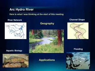
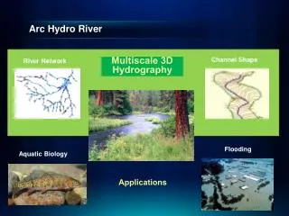
Q2: Arc Hydro River • GIS for River Modeling and Morphology River Network Channel Shape Geography Flooding Aquatic Biology Applications
Research Questions • Q1: What has been learned from the various hydrologic geospatial data models in the past ten years and how can this knowledge best be applied in future hydrologic applications? • Q2: What geospatial model can best handle the predicted future of hydrologic data? • Q3:How can estimated flow values and flow regimes be represented on geometric networks?
Research Questions • Q1: What has been learned from the various hydrologic geospatial data models in the past ten years and how can this knowledge best be applied in future hydrologic applications? • Q2: What geospatial model can best handle the predicted future of hydrologic data? • Q3:How can estimated flow values and flow regimes be represented on geometric networks?
Summary • We need a simpler, more sustainable hydrologic conceptual model • Allow analysis layer to “live” under display layers • Synthesize with wealth of online observations data • Intellectual backbone of Arc Hydro River • Model should accommodate time series and information products for individual catchments in a network
Indicators of Completion “How can we tell when it’s done?” When a time series exists on a network that represents flow values and/or flow regimes, being based on a geospatial model that incorporates best principles and practices from the past.