Working with Citizen Scientists:
Explore a case study of citizen scientists in Oregon conducting a stream biomonitoring project. Learn about the challenges, outcomes, and community impact of this initiative.

Working with Citizen Scientists:
E N D
Presentation Transcript
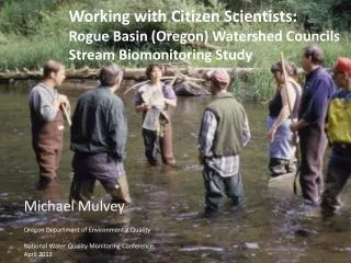
Working with Citizen Scientists: Rogue Basin (Oregon) Watershed Councils Stream Biomonitoring Study Michael Mulvey Oregon Department of Environmental Quality National Water Quality Monitoring Conference, April 2012
What do watershed councils do? Almost anything they want
Rogue Basin Biomonitoring Study • conducted by • the Rogue Basin Coordinating Council in 2004 Two Goals • Monitoring and Assessment. Photo by Jeff Adams. Used with permission. Education and Outreach
Monitoring & Assessment Approach: • EPA’s probabilistic stream survey study design • Wadeable streams stratified by 8 watershed council jurisdictions & stream order • 256 original random sites • 83 sites considered • 46 sites surveyed • Field methods adapted from EPA’s EMAP and DEQ protocols • Benthic macroinvertebrates • Stream substrate, riparian vegetation condition, human disturbance, wild life Sites Considered
Biomonitoring Project Phases • Initial Project Planning: Guidance form Experts • EPA: random site selection, funding grant. • DEQ: method development, sampling equipment, technical assistance. • The Xerces Society: technical assistance, field crew training.
Biomonitoring Project Phases, continued • Field Work Phase • 8 Paid WC Coordinators: Landowner contact, field crew coordination, equipment tracking. • Many WC Volunteers: actual field work. • Project Coordinator: oversight of project, data compilation and documentation
Biomonitoring Project Phases, continued • Laboratory Phase: MacroinvertebrateSamples • Certified taxonomist: • Samples processed and identified macroinvertebrates, entered raw data into spreadsheets • DEQ data analysis: • Calculates community and stressor scores • Data storage. Data available to others. Important: These macroinvertebrate data can be used by other programs because common study design, sampling target, field sample collection protocols and data analysis methods were used and documented.
Biomonitoring Project Phases, continued Final Phase: Data Analysis and Final Report Writing • DEQ: has done the data analysis, summary graphs, and reported back to WC members. • DEQ & Watershed Councils: report writing discussed but not begun.
Challenges • Lots of turn over in WC participants • Lots of turn over in key agency staff • One WC dropped out entirely • QA/QC protocols not followed: no replicate surveys • Sampling bias: publicly owned sites over represented • Difficult to get WC members interested in report writing • WC support for repeating this survey hard to figure • Great opportunities for future work!! • DEQ budget & staffing problems makes current support weak and continued support questionable.
Positive outcomes • Good quality and quantity of work • Data documentation excellent • Macroinvertebrate data used by DEQ in other programs: • Clean Water Act reporting: 303d List • Forest Streams Report for Or Dept of Forestry • Education and Outreach: • “Kids and Bugs” and “Latino Kids and Bugs” continues and grows
Land Use of Considered Original Sites (N=65) Rural Residential, 5