Download

1 / 27
270 likes | 391 Vues
The October 2002 Winter Weather Workshop focused on improving forecasting and communication strategies for winter weather phenomena. Key topics included the significance of winter storms as hazards, performance measures for warnings, and new policy directives aimed at better meeting user needs. The workshop emphasized the challenges of forecasting mesoscale events and the importance of optimizing lead times for decision-makers. Training on methodologies and tools for effective winter weather warnings and advisories was a major theme, alongside discussions on precipitation type forecasting and effective communication strategies.

E N D
Why Train on Winter Wx? • Significant hazard to life and property • 70-80 deaths / year • $ 1 to 2 Billion / year • Very difficult to forecast mesoscale events, pinpoint locations/timing/precip type of many large scale events due to complex nature of phenomena
Performance Measures • 15 hr Lead Time on Warnings • 90% POD • 27% FAR • Focus on science and societal impacts to improve services
New Policy DirectivesNWSI 10-513 • Outlooks • >30 % chance of event in next 3-5 days • Watches • >50 % chance of event in next 12-48 hrs • Warnings • 80% chance of event exceeding local criteria in next 36 hrs • Mention specific amounts
New Directives • Get out of comfort zone • Learn from failure • Develop local criteria that meets user needs • Determine optimal lead times for decision makers
Winter Weather Forecast Process • PDS Competency Units based on Specific Job Duties in the Winter Weather Warning Process The PDS includes training on the tools, methodologies, time lines, and strategies used in preparing winter weather watches, advisories, and warnings
User Needs(PCU1) Assess customer requirements and societal impacts related to our winter weather products and services Optimize lead times to help decision makers IC 1 Eastern Region Best Practices Report See handout and user needs presentation
Climatology(PCU 2) • Rarity of storms (use Grumm’s web site) • http://www.wdtb.noaa.gov/workshop/WinterWxII/Presentations/sigwxau02-new.ppt • Recognize Arctic Outbreak Patterns • See Brad Bramer’s presentation
Conceptual Models (PCU 3 – 4) • Important to give physical basis for forecast adjustments • Subjective and Objective forecaster techniques Synoptic NWP Mesoscale Adjustments IFPS grids
NWP (PCU 2-4) • Continues to improve with better resolution pcpn schemes • Know changes to GFS, Eta, NMM, RUC-20, SREF output • METED web site • http://www.wdtb.noaa.gov/workshop/WinterWxII/Presentations/WHATSNEW.PPT
HPC Guidance (PCU 2 to 4 ) • Use it • Know terms • Coordinate with HPC • http://www.wdtb.noaa.gov/workshop/WinterWxII/Presentations/winterwx2.shw
Ensembles (PCU 2-3) • Use them in objective forecast process to recognize consistencies or uncertainties in model output • Not always right! • http://wwwt.emc.ncep.noaa.gov/mmb/SREF/SREF.html
Synoptic Assessment(PCU 3) • QG forcing and Fn • http://www.wdtb.noaa.gov/workshop/WinterWxII/Presentations/SCHULTZ_.PPT • Ingredients method (4-panel method of diagnosis) • http://cimss.ssec.wisc.edu/goes/visit/ingredients.html
Precipitation Type Forecasting(PCU 3-4) • Microphysics (top down approach) • Know strengths and limitations of various precipitation type techniques / algorithms (eg, Ramer, Bourgouin, Baldwin, etc) • Use BUFKIT (dendritic growth zone, pcpn type) • http://wdtb.noaa.gov/resources/projects/BUFKIT/index.html • http://www.wdtb.noaa.gov/workshop/WinterWxII/Presentations/ptype_wdtb_day3_aug2002.shw • Complete exercise form using BUFKIT
Precip Type Fcstg Methodologybeyond 72 hours (PCU 3) • Use pattern recognition and assess thickness values
Precip Type Fcstg Methodology24 to 72 hours (PCU 3) • Use most consistent model to target potential • Top down approach • Ice… –12C • Identify range of possibilities
Precip Type Fcstg Methodologywithin 24 hours of expected event(PCU 4) • Still use top down approach with higher resolution models but begin to incorporate more remotely sensed data to modify model output
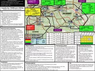
Mesoscale Analysis /Real-time(PCU 4 – 5) • Banding potential (location of Fn) • SPC meso guidance • Use satellite trends for timing of features, forcing mechanisms, tstms can warm sfc T • Radar orientations/ echo circles/bright band • Use Spotters • http://www.wdtb.noaa.gov/workshop/WinterWxII/Presentations/frontogenesis_talk_020809.ppt
Topo forcing (PCU 4) • Know basics of mountain flow • COMET web site • http://meted.ucar.edu/mesoprim/flowtopo/index.htm • Improved grid spacing can help
Use of Mesoscale Models(PCU 4) • Goal is to improve knowledge of the forecast process and use of mesoscale models • Big Bang for Buck • Can help forecasters determine local responses to various weather regimes • If you capture the forcing, you can capture the response • See Bob Roz.’s LAM considerations (domain size, time, resolution, phenom of interest)
Forecasting Blizzards/High winds(PCU 5) • Recognize factors for development • Brad Bramer’s talk • Review representative case study (Sept. 11, 2001)
Effective Communication(PCU 6) • Timing is everything • Make sure our products tell the whole story • Snow accum not enough • societal impacts should be coordinated prior to the season
IFPS Smart Tools • Precipitation type algorithm
ScenarioLessons Learned • Coordination with HPC and adjacent WFOs helped in the decision-making process • SREF ensembles helped in the forecast process • 4-panels of “ingredients”, 2-D Fn helpful, model soundings (using BUFKIT) great for p-type forecasting (Weta) • satellite trends helpful in snowfall rates and amounts
Where do you go from here? • All presentations will be on WDTB winter weather web site (wdtb.noaa.gov ) • Make training stick by being an example • Use the PDS on winter weather • You’ll be hearing from us after this winter to see how techniques & training were applied
Making Training Stick Like Glue • Plan • Research • Inform and communicate expectations • Objectively Observe • Role Model • Inspire, instill, internalize • Test techniques • Yes attitude