FORCES THAT CHANGE THE SURFACE OF THE EARTH
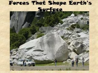
FORCES THAT CHANGE THE SURFACE OF THE EARTH. Mountain Range, Canyon, & Delta. L andforms are subject to change due to agents of weathering. water wind ice.

FORCES THAT CHANGE THE SURFACE OF THE EARTH
E N D
Presentation Transcript
Mountain Range, Canyon, & Delta Landforms are subject to change due to agents of weathering water wind ice
Predict how weathering will change this mountain range.Which agents of weathering might work on these mountains?How would changes to this mountain range be reflected on a map?
Grand Canyon Arizona
Predict how weathering will change this canyon.Which agents of weathering might work on this canyon?How would changes to this canyon be reflected on a map?
Mississippi RiverDelta Louisiana
Predict how weathering will change this delta.Which agents of weathering might work on this delta?How would changes to this delta be reflected on a map?
Thinking Topographically • Topographic Maps-- 3-d ups and downs of the terrain shown on a 2-d surface • Topography – shapes and features of the Earth’s surface
Terms to Know and Understand • Contour lines – connect places on a topographic map of the same elevation • Elevation – height above sea level • Contour line intervals – vertical distance between contour lines
Topographic Labeling • Topographic maps: • must have scale and interval defined. • use color • use index contours ( wider lines with elevations)
Goal for today • Go to my webpage and go through the following links: • Map Match • Reading a Map When you finish, pick up a pack of vocabulary cards, match the term with the definition and write them on a sheet of paper.
Topography The study of the shapes and features of the Earth’s surface.
Topographic Map Shows the three dimensional shape and elevations of an area of land in two dimensions
Elevation Height above sea level
Contour line Line that connects places on a topographic map that are all at the same elevation (eventually a closed loop) Contour line
Contour Line Interval The vertical difference in elevation between neighboring contour lines contour line interval
Relief The difference between the highest elevation point and the lowest elevation point on a map 200 300 400 Units = feet What is the relief of this map? What is the contour interval of this map?
Topographic Map Rules • Contour lines are closely spaced on steep slopes. • Contour lines are widely spaced on gentle slopes.
Topographic Map Rules Where a contour line crosses a stream or valley, the contour line bends to form a “V” that points upstream. In the upstream direction, the successive contours represent higher elevations.
Topographic Map Rules • Contour lines near the top of a hill form closed, circular shapes. The top of the hill is higher than the highest closed contour line.
Topographic Map Rules • Depressions without outlets are shown by closed hatched contours. The contour lines have short lines on the inside that are pointing down slope. The bottom of the depression is lower than the lowest closed contour line.
Satellite Map A map made of pictures of the Earth taken from a satellite orbiting the Earth.