Ocean Circulation
Ocean Circulation. Ocean Circulation. Ocean currents are affected by two kinds of forces; the primary forces that start water moving and determines its velocity. Secondary forces are factors that influence the direction and nature of its flow. Ocean Circulation.

Ocean Circulation
E N D
Presentation Transcript
Ocean Circulation • Ocean currents are affected by two kinds of forces; the primary forces that start water moving and determines its velocity. • Secondary forces are factors that influence the direction and nature of its flow.
Ocean Circulation • Primary forces are the stress of wind blowing over the water, thermal expansion and contraction of water as well as different densities between layers. • Secondary forces and factors are the Coriolis effect, gravity, friction, and the shape of the ocean basins themselves.
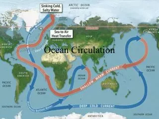
Ocean Circulation • About 10% of the water in the world ocean is involved in surface currents. • Surface currents are considered horizontally flowing water in the uppermost 400 meters (1,300 ft.) of the ocean’s surface. • Most surface currents move water above the pycnocline.
Surface Currents • Solar heating causes water to expand slightly. Because of this, sea level near the equator is about 8 centimeters higher than sea level in temperate oceans. • This global difference creates a very slight slope, and warm equatorial water flows downhill (poleward) in response to gravity.
Surface Currents • The difference in temperature between the poles and the equator is not the major primary force responsible for surface currents • The major primary force for surface currents is the winds. • As winds blow over the surface of the ocean, energy from the wind is transferred to the water buy the shear effect.
Surface Currents • The wind blowing over the water puts the water beneath it into motion. • As a rule of thumb, the friction of wind blowing for at least 10 hours will cause surface water to flow downwind at about 2% of wind speed. • Because of the Coriolis effect, Northern Hemisphere currents flow to the right of the wind direction.
Surface Currents • Continents and the shape of ocean basins often block continuous flow and help deflect the moving water into a circular pattern. • This flow around the periphery of an ocean basin is called a gyre.
Surface Currents • Oceanographers subdivide the North Atlantic Gyre into four different currents. • The water in the gyres flow around the periphery of the ocean basin because of the Coriolis effect. • One might expect the water within a gyre to pile up in the center and stop moving as a result of the Coriolis effect.
Surface Currents • But it does not, due to another phenomenon. • It was discovered in the early part of the twentieth century that the topmost layer of water in the ocean in the Northern Hemisphere flows at about 45-degrees to the right of the wind direction.
Surface Currents • The surface layer puts the layer below into motion and that layer is deflected 45-degrees to the right of the layer below it. • The same thing happens in the layer below that, and so on, to a depth of about 100 meters (330 feet) at mid-latitudes. • Because of frictional losses each lower layer moves more slowly than the layer above it.
Surface Currents • The resulting situation is known as the Ekman spiral. • The net motion of the water down to abut 100 meters, after allowances for the summed effects of Ekman spiral is known as Ekman transport. • In theory Ekman transport in the Northern Hemisphere is 90-degrees to the right of the wind direction at the surface.
Surface Currents • Theoretically the currents could be deflected by the Coriolis and the water pile up in the center of the ocean and the circulation stop. • A deviation in the theory occurs because of an interaction between the Coriolis and the pressure gradient.
Surface Currents • As the water is deflected to the right by the Coriolis it builds up a hill of water in the middle of the gyre. • After a point the force of gravity (pressure) forces the water down the hill, still being deflected by the Coriolis. • A balance is developed between the force of the Coriolis building the hill and gravity pulling the water down.
Surface Currents • The phenomenon just described is called a geostrophic current. • Yes, there really is a hill near the middle of the North Atlantic, centered in the area of the Sargasso Sea. • It is not a steep mountain of water. Its maximum height is about 2 meters (6.5 feet).
Gyres • Within the subtropical gyres there are two main types of currents. • They are western boundary currents and eastern boundary currents. • The fastest and deepest currents are found at the western boundary of ocean basins (off the east coast of continents).
Western Boundary Currents • Narrow, fast, deep western boundary currents take warm water toward the poles. • There are five large western boundary currents; the Gulf Stream, the Kuroshio Current, the Brazil Current, the Agulhas Current, and the East Australian Current.
Western Boundary Currents • Western boundary currents tend to meander as they travel poleward. • The looping meanders sometimes connect to from turbulent rings, or eddies, that trap cold or warm water in their centers and then separate from the main flow.
Western Boundary Currents • An example; cold-core eddies form in the Gulf Stream as it meanders eastward upon leaving the coast of North America off Cape Hatteras. • Warm-core eddies can form north of the Gulf Stream when the warm current loops into the cold water lying to the north.
Eastern Boundary Currents • There are five eastern boundary currents at the eastern edge of the ocean basins. • They are; the Canary Current, the Benguela Current, the California Current, the West Australian Current and the Peru or Humboldt Current.
Eastern Boundary Currents • Eastern boundary currents carry cold water equatorward; they are shallow and broad, sometimes more than 1,000 kilometers (620 miles) across. • Their boundaries are not well defined and eddies do not tend to form.
Western Intensification • Western boundary currents are concentrated because of the converging flow of the trade winds. • The trade winds blow water westward where it piles up. This heightens the Coriolis effect, the water turns to the right and heads north.
Western Intensification • Another reason this water piles up on the western side of the ocean basin is the rotation of the Earth. • These forces combine to produce a phenomena known as the western intensification of currents.