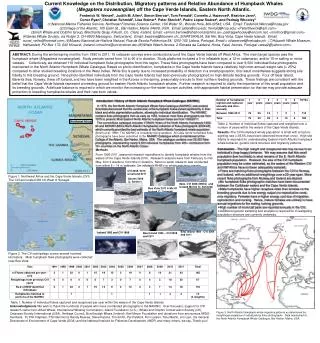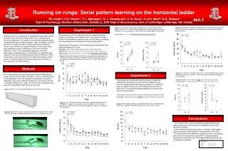
Methods
---. t =- r u’v’. t o. Field measurements of prototype stream. Determine NBSS field measurement method. Develop NBSS prediction equation. Develop scaled model and conduct flume study. Theory. Field testing. Instrument. Cross section View.

Methods
E N D
Presentation Transcript
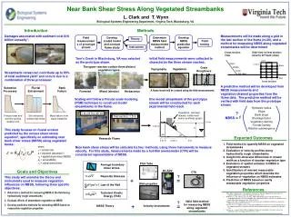
--- t=-ru’v’ to Field measurements of prototype stream Determine NBSS field measurement method Develop NBSS prediction equation Develop scaled model and conduct flume study Theory Field testing Instrument Cross section View Side View (of test section; assume 30o bank slope) 0.5 m Upper 0.125 m Bank Middle Lower Toe Bed Streambank retreat can contribute up to 85% of total sediment yield2 and occurs due to a combination of three processes: Bed 1 2 3 4 Cross sections Subaerial Processes Fluvial Entrainment Bank Failure Scaling will follow a Froude scale modeling (FSM) technique to construct model streambanks in the flume. One model streambank of the prototype stream will be constructed for each experimental field reach. --- t=C2rw’2 1 m x 6 m x 40 cm Vegetation (wooden dowels, metal mesh and/or synthetic grass) Freeze-thaw and wet-dry cycling weaken soil Soil entrained during high flows Mass failure from slope instability Test section, 1.5 m 0.4 m 0.25 m D Research Flume 90o 30o 0.07 m 0.43 m 2*D Goals and Objectives 3D ADV Pitot Tube This study will examine the theory and instruments used to measure vegetation influences on NBSS, following three specific objectives: • Determine a method for measuring NBSS in the field along hydraulically rough streambanks • Evaluate effects of streambank vegetation on NBSS • Develop predictive methods for estimating NBSS based on measurable vegetation properties References ( ) Law of the Wall U=f yu*/n • ARS. 2003. Helping states slow sediment movement: a high-tech approach to clean water act sediment requirements. Agric. Res. Magazine 51(12): 12-14. • Wallbrink, P.J., A.S. Murray, and J.M. Olley. 1998. Determining sources and transit times of suspended sediment in the Murrumbidgee River, New South Wales, Australia, using fallout 137Cs and 210Pb. Water Resources Res. 34(4): 879-887. • Trimble, S.W. 1997. Contribution of stream channel erosion to sediment yield from an urbanizing Watershed. Science 278: 1442-1444. • Prosser, I.P., A. O. Hughes, and I. D. Rutherfurd. 2000. Bank erosion of an incised upland channel by subaerial processes: Tasmania, Australia. Earth Surface Processes Landforms 25(10):1085- 1101. • Hanson, G. J., and A. Simon. 2001. Erodibility of cohesive streambeds in the loess area of the midwestern USA. Hydrological Processes 15: 23-38. u* Turbulent Kinetic Energy (TKE) CTA Near Bank Shear Stress Along Vegetated Streambanks L. Clark and T. Wynn Biological Systems Engineering Department, Virginia Tech, Blacksburg, VA Introduction Methods Damages associated with sediment cost $16 billion annually1. Measurements will be made along a grid in the test section of the flume (n=20), and a method for measuring NBSS along vegetated streambanks will be determined. Tom’s Creek in Blacksburg, VA was selected as the prototype steam. Initial field measurements were collected to characterize the three stream reaches. The upper reaches contain three distinct vegetation types: Grain Roughness Topography Vegetation A predictive method will be developed from NBSS measurements and vegetation/channel properties from the flume data. The predictive method will be verified with field data from the prototype stream. A flume model will be created using the field measurements. Forested Mixed (shrubs) Herbaceous Hydraulic radius Slope Bank slope Blockage factor Vegetation density Frontal Density Relative submergence ? = f NBSS This study focuses on fluvial erosion predicted by the excess shear stress equation3, specifically on estimating near bank shear stress (NBSS) along vegetated banks. Expected Outcomes • Field method to quantify NBSS on vegetated streambanks • Evaluation of velocity profiles along hydraulically rough streambanks • Insight into observed differences in stream width as a function of riparian vegetation type • Evaluation of spatial variation in NBSS in vegetated streams • Identification of relevant measurable vegetation properties which describe the influence of vegetation on NBSS estimates • Prediction of NBSS based on easily measurable vegetation properties where e = erosion rate a = exponent (assumed 1) ta = applied shear stress (NBSS) kd = soil erodibility tc= critical shear stress Near bank shear stress will be calculate by four methods, using three instruments to measure velocity. For this study, measurements made by a hot-film anemometer (CTA) will be considered representative of NBSS. e = kd(ta-tc)a Average boundary shear stress ? Reynolds Stresses + = Mini-propeller Valid field method for measuring NBSS along vegetated streambanks ? + = NBSS Theory Velocity Instruments