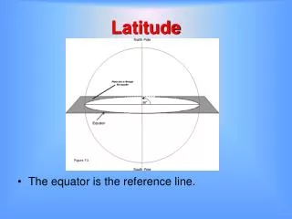
LATITUDE
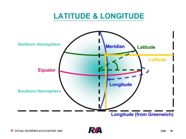
LATITUDE. Latitude lines run ____ to ____, but are measured _____ & _____. The 0 of latitude that circles the earth is called the _______?. LATITUDE. latitude - fatitude. 0. 0. Latitude lines run east to west , but are measured north & south.

LATITUDE
E N D
Presentation Transcript
LATITUDE • Latitude lines run ____ to ____, • but are measured _____ & _____ The 0 of latitude that circles the earth is called the _______?
LATITUDE latitude - fatitude 0 0 • Latitude lines run east to west, • but are measured north & south The 0 of latitude that circles the earth is called the equator
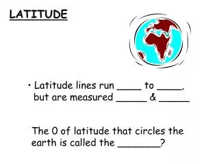
LONGITUDE Longitude lines run _____ to _____, but are measured ____ and ____ The 0 line of longitude that extends from the _____ to the_____ Pole is called the _______ _______
0 LONGITUDE 0 Longitude lines run north to south, but are measured east and west The 0 line of longitude that extends from the North to the South Pole is called the Prime Meridian
KWAKIUTL • Northwest/Coastal Range • Rainy but mild climate salmon (food) platform house w/totem pole
KWAKIUTL fisherman (economy) Canoe transportation
SIOUX/LAKOTA • Great Plains • Dry grass land Buffalo (food) Teepee (homes)
SIOUX/LAKOTA • nomadic • hunters • (economy) Horses (transportation)
IROQUOIS • Eastern Woodland • Appalachian Mtn. • Coastal Plain • corn, beans, squash(3 sisters) • deer wigwam/longhouse homes
IROQUOIS • Family subgroup:
IROQUOIS • Family splinter group: • Seneca • Cayuga • Onondaga • Oneida • Mohawks Fur trading (occupation) heavily forested 4 seasons Foot (transportation)
INUIT • Canadian Shield • Arctic Circle • Alaska & Canada • very cold/snow & ice Seal & whale (food) Igloo (homes)
INUIT Hunting/fishing (economy) Kayak & Dogsled (transportation)
PUEBLO • Basin & Range • southwest • New Mexico/Arizona • desert-hot/dry pueblo/hogan (homes) Corn=maize (food)
PUEBLO Horse (transportation) Herdsmen, traders (economy)
AMERICAN INDIANS NATURAL RESOURCES
AMERICAN INDIANS NATURAL RESOURCES forest animal/animal skins (shelter) (food & clothing) fish ice/water
BERINGIA Land bridge that allowed Asians to follow herds (migrate) into North America
COLORADO RIVER Colorado River
COLORADO RIVER • This river was explored by the • Spanish & runs through the • Grand Canyon
RIO GRANDE RIVER Rio Grande River
RIO GRANDE RIVER • Forms a border with Mexico Mexico
COLUMBIA RIVER Columbia River
COLUMBIA RIVER • Explored by Lewis & Clark
OHIO RIVER Ohio River Mississippi River
OHIO RIVER • Gateway to the west
MISSISSIPPI & MISSOURI RIVERS Missouri Mississippi River River
MISSISSIPPI & MISSOURI RIVERS • “The transportation arteries for farm • and industrial products. • Links to ports and other parts • of the world
GULF OF MEXICO Gulf of Mexico
GULF OF MEXICO • Provided the French & Spanish with • exploration routes to Mexico • and parts of America
ATLANTIC & PACIFIC OCEANS 4-Lake Michigan 1-Lake Superior 2-Lake Huron 5-Lake Erie 1 3-Lake Ontario 2 3 4 5 Atlantic Ocean Pacific Ocean
ATLANTIC & PACIFIC OCEANS • Atlantic Ocean – served as the • highway for explorers, early • settlers, & later immigrants
What facts Do you know About america’s Waterways ???
FACTS TO KNOW: • America’s waterways have been • important for trade, transportation • and settlement • The location of the United States, • with its Atlantic and Pacific Coasts, • has provided access to other • areas of the world
ST. LAWRENCE RIVER St. Lawrence River
ST. LAWRENCE RIVER • Forms part of the NORTHEAST border • with CANADA and connects the • GREAT LAKES to the ATLANTIC • OCEAN St. LAWRENCE RIVER CANADA ATLANTIC OCEAN U.S.
ST. LAWRENCE & HUDSON RIVERS Lake Huron Lake Superior Lake Ontario St. Lawrence River Lake Michigan Hudson River Lake Erie GREAT LAKES
GREAT LAKES • Inland port cities grew in the Midwest • along the Great Lakes
COASTAL PLAIN Location: along the Atlantic Ocean & Gulf of Mexico Physical Characteristics: broad lowland providing many excellent harbors