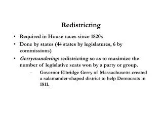
TAC GIS Redistricting Data
Understand the demographic data of San Jacinto County for the redistricting project since 1981. Access detailed information on population, race, ethnicity, and voting age demographics for informed decision-making. Stay updated on the adjusted boundaries submitted in 2011 and the significance of the project.
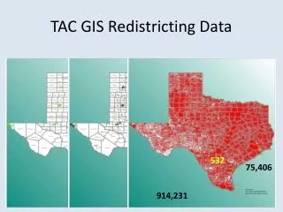

TAC GIS Redistricting Data
E N D
Presentation Transcript
TAC GIS Redistricting Data 532 75,406 914,231
Included Demographic Data • TotalPop Total Population • WhiteNonHi White Non-Hispanic • AmerIndian American Indian • AsianAlone Asian Alone • BlackAlone Black Alone • HawaiianNo Hawaiian • SomeOtherR Some Other Race • TwoOrMoreR Two or more Races • Hispanic Hispanic • VotingAgeP Voting Age Population • WhiteNon_1 White Non Hispanic Voting Age • AmerIndi_1 American Indian Voting Age • AsianAlo_1 Asian Alone Voting Age • BlackAlo_1 Black Alone Voting Age • Hawaiian_1 Hawaiian Voting Age • SomeOthe_1 Some Other Race Voting Age • TwoOrMor_1 Two or more Races Voting Age • HispanicVo Hispanic Voting Age
San Jacinto County Redistricting Project • Is there a need to redistrict? • Hadn’t Redistricted Since 1981
San Jacinto County Redistricting Project Adjusted Boundaries Submitted Nov. 8, 2011 Adjusted Boundaries Submitted Sept. 8, 2011 2010 CENSUS w/ 2008 Precinct Boundaries
San Jacinto County Redistricting Project • Since They Hadn’t Redistricted Since 1981
County Information Project (CIP)Texas Association of Counties • Tim Brown, CIP Manager, Senior Analyst • Paul Emerson, State Fiscal Analyst • Bruce Barr, County Analyst - GIS, Emergency and Floodplain Management http://ww.txcip.org/tac/census/CountyProfiles.php http://texcounty.net/