Download
1 / 20
210 likes | 482 Vues
NASA/GSFC. Evolution of NASA’s Earth Observing System Data and Information System (EOSDIS) Mary Ann Esfandiari Deputy Associate Director for EOS Operations NASA/Goddard Space Flight Center August 1, 2006. Earth Observing System Data Management.

E N D
NASA/GSFC Evolution of NASA’s Earth Observing System Data and Information System (EOSDIS) Mary Ann EsfandiariDeputy Associate Director for EOS Operations NASA/Goddard Space Flight Center August 1, 2006
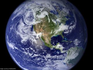
Earth Observing SystemData Management • NASA’s Earth Observing System Data and Information System (EOSDIS) is a petabyte-scale archive of environmental datathat supports global climate change research • EOSDIS provides for • Data ingest • Data processing • Data distribution • Archive management This MODIS image shows the wide sediment plume of the Yangtze River as it empties into the East China Sea. Credit: Jacques Descloitres, MODIS Land Science Team Image Date: 09-16-2000
Aqua (5/02) Aura (7/04) Terra (12/99) SORCE (1/03) Solar Irradiance TIM, SIM, XPS SOLSTICE Jason (12/01) Ocean Altimetry Poseidon/ JMR/DORIS Energy Budget CERES Surface Imaging MODIS Atmospheric Sounders AMSR-E AIRS/AMSU/HSB Trace Gases TES Atmospheric Dynamics and Chemistry HIRDLS, MLS, OMI Lower Atmospheric Chemistry MOPITT Albedo, Aerosols, Vegetation MISR Energy Budget CERES Surface Imaging MODIS ASTER ACRIMSAT (12/99) Solar Output ACRIM Mesosphere Stratosphere O3 ClO BrO OH trace gases TRMM (11/97) Energy Budget CERES, LIS QuikScat (6/99) Sea Surface Winds SeaWinds METEOR 3M (12/01) Aerosol Trace Gases SAGE III ICESat (1/03) Ice Topography And Altimetry GLAS Rain Troposphere Rain O3 precursor gases Temperature Moisture Ecosystem Dynamics Sea Surface Winds Evaporation H2O Volcanology Sea Ice Ocean Biology Land Ice and Snow Cover Land Biology Fire Occurrence Mission & Science 06192006.ppt EOSDIS Manages DataFor All 24 EOS Measurements
Earth Observing System Data Management • NASA’s Earth Observing System (EOS) • Mission is to collect Earth remote sensing data for a 15 year global change research program • EOS Data and Information System (EOSDIS) Overview • Designed to receive, process, distribute and archive several terabytes of science data on a daily basis • Provides a distributed information framework (data centers, system elements, interfaces and data model) supporting EOS investigators and other users • Interoperates with data archives of other agencies and countries • Distributed Active Archive Centers (DAACs) • Science Investigator-led Processing Systems (SIPS) • Web Site: http://eos.nasa.gov/eosdis
SEDAC Human Interactions in Global Change NSIDC Cryosphere Polar Processes EDC Land Processes & Features ASF SAR Products Sea Ice Polar Processes GSFC Upper Atmosphere Atmospheric Dynamics Global Biosphere LaRC Radiation Budget,Clouds Aerosols, Tropospheric Chemistry ORNL Biogeochemical Dynamics EOS Land Validation GHRC Global Hydrology JPL Ocean Circulation Air-Sea Interactions DAAC Alliance Data Centers
Distributed Active Archive Centers (DAACs) REASoN ACCESS Adapted from Instrument Science Team Facilities (SCFs and SIPSs) Data Assimilation Model EOSDIS Context
EOSDIS Scale • EOSDIS managing extraordinary rates and volumes of scientific data • Terra alone produces 194 GB of “raw” data/day; almost as much as the Hubble Space Telescope (HST) in one year • Adding 4 TB of data per day • Current EOSDIS data archive volume is approximately 4.9 PB • Distributing 2.5 TB of data per day to users • Over 36 million products distributed to ~ 200,000 distinct users per year; ~ 2 million distinct users per year access EOSDIS DAACs
EOSDIS Evolution • In early 2005, NASA embarked on an EOSDIS Evolution Study • Address multi-faceted goals/issues: • Manage archive volume growth • Improve science need response and data access • Reduce recurring costs of operations and sustaining engineering • Update aging systems and components • Move towards more distributed environment • A vision for the 2015 timeframe was developed to guide conduct of study • EOSDIS Evolution “Step 1” Plan approved by NASA Headquarters in late 2005.
Features of EOSDIS Evolution (1 of 3) • Migration to commodity-based hardware • reduces maintenance and technology refresh costs • Transfer responsibility for archive and distribution of MODIS (Moderate Resolution Imaging Spectroradiometer) Level 0, Level 1, and Atmosphere (Level 2) data from Goddard DAAC to MODIS data processing facility (MODAPS) • Move from archiving all products to on-demand production of Level 1 • Decrease archive size and slow future growth; facilitates transition to disk-based archive (all data on-line) • Closer relationship/control by science community expected to be more responsive to science needs, products, tools
Features of EOSDIS Evolution (2 of 3) • Rearchitect EOSDIS Core System (ECS) to reduce footprint; simplify system (removes 750K SLOC (current baseline 1.2M SLOC) and 15 S/W Components) • Reduced operations/sustaining engineering costs • Improved performance • At Goddard and Langley DAACs, consolidate data holdings into single, in-house developed system at each DAAC (currently operating ECS and heritage systems at both DAACs) • Reduction in operations costs due to elimination of multiple systems
Features of EOSDIS Evolution (3 of 3) • Earth Science ClearingHOuse(ECHO) • Independent reviews conducted • Prioritize efforts to focus on achieving higher operational maturity (ingest, reconciliation, search and order, performance, error handling) • Global Change Master Directory (GCMD) portal to ECHO underway • WIST The Warehouse Inventory Search Tool (WIST) (general ECHO client that searches across all of ECHO’s holdings) fully operational, and users are routinely accessing EOS data via WIST/ECHO. • ROSES/ACCESS solicitation out for ECHO clients • Current Holdings • Collections 2,237 • Granules 56 million • Browse 14 million
Key Benefits of Proposed “Step 1” Plan • Maximize Science Value • Data access easier and data products quickly available to science community • MODIS data more closely integrated with science community • Potential pathfinder for migration of other data into science communities • Substantial Cost Savings • Addresses operational and sustaining engineering • Takes advantage of current IT advances • Investments provide return on value within 3 years • Manageable Risk • Minimizes software development efforts • Builds upon existing systems • Utilizes steps within plan as proof of value before proceeding • Reduces footprint for EOSDIS Core System
EOSDIS Data Science Examples • Arctic sea Ice • Animation (20 second) showing the Spring retreat and subsequent Autumn advance of sea ice over the Arctic from 10/1/2002 through 4/21/2003 using AMSR-E data • Highlights fissures in the sea ice. • MODIS High Resolution Cloud Detection • Improved resolution from GOES to MODIS • National Weather Service, NOAA and NASA working together to improve severe weather prediction • 30 day fire potential forecast • Historical data mined 2001-2003 to develop model • Correlated with actual fire data from MODIS – black dots
NASA and National Weather Service formed Short-term Prediction Research and Transition Center (SPoRT) to help forecasters better incorporate satellite data into their decision making process. Shows specialized products using MODIS data. • MODIS instrument provides higher resolution(250m-1,000m) measurements of cloud cover, and cloud surface detail and is being used to estimate cloud thickness, cloud height, and fog over specific regions. • Together with NOAA and NWS, NASA is now providing near real-time precipitation and • cloud data to help forecasters better anticipate the impact of storm systems far off shore to be detected by land-based radars.
EOSDIS Future • NASA’s EOSDIS is one of the richest sources of Earth Science data and its mined contents hold the keys to knowledge and understanding of long term climate variability and the major processes that drive the Earth’s systems • Evolution viewed as a very positive change; • Step 1 changes only partially address the 2015 vision • Substantial work yet to be done to fulfill the vision • Paving the way to 1) Increase data usage; 2) Improve data access; 3) Increase participation; 4) Reduce sustaining costs • Door is OPEN and the opportunities are bright to Mine, Explore, Discover, Understand, Solve, and Amaze