Download
1 / 14
140 likes | 406 Vues
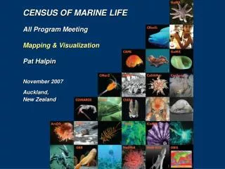
CENSUS OF MARINE LIFE All Program Meeting Mapping & Visualization Pat Halpin November 2007 Auckland, New Zealand. Partner: National Geographic Society. Print Publications. Print Mapping. Internet Mapping. Partner: Google. Google Maps (browser). Google Earth (application).

E N D
CENSUS OF MARINE LIFE All Program Meeting Mapping & Visualization Pat Halpin November 2007 Auckland, New Zealand
Partner: National Geographic Society Print Publications Print Mapping Internet Mapping
Partner: Google Google Maps (browser) Google Earth (application)
Ocean data from NASA - JPL Marine animal data from SEAMAP Listed in Layers box with custom query popup windows Oceanographic SST SSH Chlorophyll Current OBIS-SEAMAP Datasets Species Custom Query MEBM DSS Sample popup window from SEAMAP Online Mapper (under development) at http://seamap.env.duke.edu/prod/mapservice/googlemaps/seamap_gm.phtml
Mapping Census Activities Coml.org - Census of Marine Life Portal Google Map For project locator / links
CoML Activities • How can we better represent all of the activities of the Census? • How do we combine multiple types of activities in an easy to understand manner? • Can we develop a dynamic chronology of the first 10 years of the Census?
A Common Technical Guide • A common guide to development of visual and mapped products will provide timely technical documentation, software usage suggestions / help, standards, protocols as well as specific templates for mapping and visualization development. • The comlmaps.org site will serve content on: • specific mapping standards and protocols, • collective internet mapping and web-services, • shared tools and scripts, • consistent base-map data, • guides to cartographic standards (digital / print), and • common templates, color palettes, graphic libraries.
Technical workshops • Fall 2008 Census mapping and visualization workshop will also be announced to take place at Duke University. This workshop will feature external experts and internal Census specialists for training, inspiring and discussing techniques with invited representatives across the Census projects. • Spring 2009 Follow-up interaction will be conducted in Long Beach, CA to coincide with the “Joint Assembly” to ensure visual consistency of the 2010 final reports. This workshop will train on use of provided templates and common visual elements, especially those cartographic in nature.
Surveys to assess needs and skills Site visits to work directly with Census research teams Online communication with email, internet chat and desktop sharing Technical development management with bug tracking, roadmaps, code versioning and on-line documentation Direct Project Interaction
NGS: Wall Map of Census Activities The National Geographic Society Product 1 Title: Census of Marine Life: Exploring Ocean Life, Past, Present, and Future Format: Wall map – 2 x 3 feet Release date: Late 2008 Description: Double-sided World map depicting the survey extents and technologies used by different research groups to census the oceans in the past and present and to model future ocean life. The map will show the spatial footprints of the surveys with text and photos of the species surveyed and the technologies employed, with inset maps and graphs of major findings. Reverse side describes the Census effort, with profiles of the research programs and sponsors, additional photographs, logos and web links. Distribution: ~100,000 copies the Society’s geography education alliance network; local language editions of National Geographic magazine; future editions of EarthPulse
NGS: Wall Map of Census Discoveries The National Geographic Society Product 2 Title: Biodiversity of the Oceans: Past, Present, and Future Format: Wall map – 2 x 3 feet Release date: October 2010 Description: Double-sided World map depicting the most charismatic species that were discovered, tracked, and modeled in the Census, along with the major findings regarding past, present, and future populations. The map will show Large Marine Ecosystems (LME) or Marine Ecoregions of the World (MEOW), with photographs of the species inhabiting them. Reverse side tells stories of the ecosystem services provided by marine biota, population and ecosystem trends, and threats to marine species and ecosystem services. Distribution: ~100,000. A major corporate sponsorship could potentially enable distribution of the map or maps to all 113,000 K-12 schools in the U.S.
NGS: Internet Atlas of Marine Life The National Geographic Society Product 3 Title: Atlas of Marine Life Format: Rich Internet Application Launch date: October 2010, with Biodiversity of the Oceans wall map Description: Map-centric website allowing users to zoom to any place on Earth and switch map themes between physical oceanographic variables, large marine ecosystems, marine ecoregions, species diversity, CoML surveys and findings (grouped by past, present, and future), marine protected areas, threats, ecosystem services values, etc. Maps are clickable to provide descriptions, stories, photos, video, audio, and graphs associated with map features. There will be links to CoML programs, sponsors, Encyclopedia of Life, and NG.com content. Distribution: The website would be accessible to a worldwide audience, and could be promoted, linked to, and/or hosted by National Geographic, the Census of Marine Life, or other partner organizations.
Announce Mapping & Visualization program Refine the scope of “mapping and scientific visualization support services” across CoML projects Distribute survey of needs and skills Identify more specific needs of CoML and projects Goals for This Week