Download
1 / 27
270 likes | 434 Vues
ELECTRONIC REMOTE SENSING IMAGES ATLAS OF THE NORTHERN EURASIA RIVER DELTAS. Zemlianov Igor, Gorelits Olga State Oceanographic Institute (SOI) Moscow, Russia. The Project Idea.

E N D
ELECTRONIC REMOTE SENSING IMAGES ATLAS OF THE NORTHERN EURASIA RIVER DELTAS Zemlianov Igor, Gorelits Olga State Oceanographic Institute (SOI) Moscow, Russia
The Project Idea Authors have suggested the project of the electronic scientific and educational atlas of the Northern Eurasia river deltas. This atlas will integrate modern remote sensing information and big scientific background (literature, maps, etc).
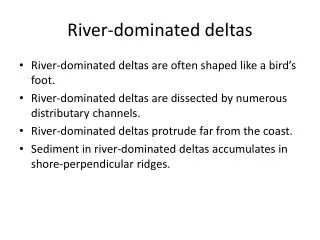
Why river deltas? River deltas are under constant interference of river and marine factors during the whole period of evolution, this interaction determines existence of unique natural environments. Since ancient times all large river deltas have been actively used by humans due to convenient arrangement and favorable natural conditions. Therefore, river deltas have always attracted researchers' attention, and a large volume of the scientific and practical information has been already collected.
The Project Goals Creation electronic atlas of the river deltas for: 1st stage: Educational system for the secondary and higher schools. 2nd stage: Scientific electronic application illustrating a geographical location and types, principles of formation, features of a structure of the chosen geographical objects in visual and text form. 3rd stage:Preparation of the applied information system, accessible to the many users, which becomes a component of monitoring and control systems of the coastal zone environment.
System requirements • Relevance • Availability • Availability for many users • Minimum technical and program requirements • Easy to use for different types of users • Students and pupils • Scientists • Decision makers
Main solution According to system requirements we use these solutions: • Geographical object: River deltas • Data source: Verbal and non verbal information • Technical solutions: Internet/Intranet technology
Data sources • Remote sensing images: Resours-01, Landsat ETM, Terra/Modis, IRS • Geographic Maps: Topographic, geologic, vegetation and other thematic maps. • Verbal sources: Scientific publications, Hydrometeorological regime information
Main processes Water dynamics: - Delta inundation during flood and flash periods; - Tidal andwind effected water level fluctuations at delta sea edge; - Dynamics of sea wind and tidalcurrents at delta offshore zone; Ice and termal processes: - Formation and breakdown of ice cover at river delta and offshore zone; - Formation of ice dams and jams at river delta. Processes of erosion and accumulation: - Hydrographic network dynamics at river delta; - Deltaoffshore zone and delta bar dynamics. Fromation of soil and vegetation cover at river delta and plant societies of delta offshore zone.
Information structure River deltas were groupped according to their belonging to sea basins. The particular basin delta areas are sequenced according to their geographical position from east to west. Studying of information concerning particular delta begins with review of small scale images covering whole delta area. The first chapter is accompanied with table and text information giving general and hydrological characterisitc of delta area. Geoimages are complemented by specilized mark up allowing to realize scheme of geographical zoning of delta area and to go from first chapter to selectedzone.
Information structure In selected regions more larger scale images are used. Special text reference gives information about geographical, hydrological and other peculiarities of selected region Increasing of image scale gives possibility to distinguish peculiarities of morphological formation, evaluate character and intensity of delta processes (with indirect criteria) – images interpretation. Using described atlas srtucture it is possible to present modern knowledge and current information concerning selected delta area and to illustrate main theses with geoimages.
Soluble tasks • Studying of the main types of the river mouths and their geographical location with application of satellite geoimages. • Studying of the initial bases of the analysis of the river mouths structure and hydrological and morphological processes using synthesized multispectral remote sensing geoimages. • Studying of the features of a structure and characteristic attributes of the river mouths of various types using examples of geoimages. • Studying of principles of formation and morphology of the main structural elements of the river mouths and main hydrological and morphological processes in the river mouths on the basis of available geoimages • The atlas can become the basisof user interface in systems of monitoring of natural objects (coastal zones for example)
Working plan • Real model of the Atlas in Internet – during 2004 year • Full realisation for North Dvina – 2005 year • The next northern river deltas 2006+ We invite you to cooperation!