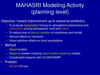
MAHASRI Modeling Activity (planned)
This project aims to assess the impact of topographic forcing on atmospheric phenomena while exploring the interactions between the atmosphere, land, and ocean. Key objectives include reducing bias in diurnal variations of cloudiness and rainfall through global and regional modeling approaches. The research will utilize cloud-system resolving models and enhance prediction capabilities, particularly for El Niño events. Improvement of initial data and model resolutions is expected to lead to more accurate predictions across various time scales, ultimately benefiting climate forecasting and atmospheric studies.

MAHASRI Modeling Activity (planned)
E N D
Presentation Transcript
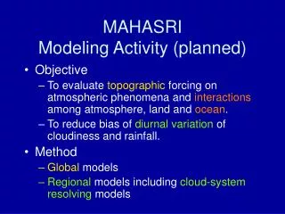
MAHASRI Modeling Activity (planned) • Objective • To evaluate topographic forcing on atmospheric phenomena and interactions among atmosphere, land and ocean. • To reduce bias of diurnal variation of cloudiness and rainfall. • Method • Global models • Regional models including cloud-system resolving models
JMA LRF Model Replacement(Plan) • 1 months prediction • 2007: Improve initial data for ensemble fcst • 2008~ : dx=120km --> 60km • 3 months prediction • 2007 : SST ensemble • El-Nino prediction • 2007: Increase resolution: • T42L40, 2.5°L40 --> T95L40, 1°L50 • 2008~ : develop unified 3-months & El-Nino prediction model with T159L60, 0.5°L60
TRMM (rainy season average) Xie et al. 2006 Regional model June 2001 August 2001 July 2001 Satomura
Spatial distribution of peak localtime of annual mean rainfall diurnal variation by AGCM • 20km AGCM captures spatial distribution of diurnal rainfall peak time over both land and the ocean within a few hours • Few difference between 20km and 120km AGCMs Arakawa & Kitoh
Daily 12h fcst exp. by HyARCusing CReSS ・ 2005.02.02 snow storm ・ Radar (left); CReSS simulation 5kmX500m (right) http://www.rain.hyarc.nagoya-u.ac.jp/CReSS/fcst_exp.html