Download
1 / 27
270 likes | 454 Vues
A Change in Hail Criteria for Severe Thunderstorm Warnings in 2010. Steve Naglic NWS WFO Columbia, SC. Motivation for the Change and Studies. NWS HQ changed the severe hail criteria from 0.75” ( penny ) to 1.00” ( quarter ) on January 4, 2010

E N D
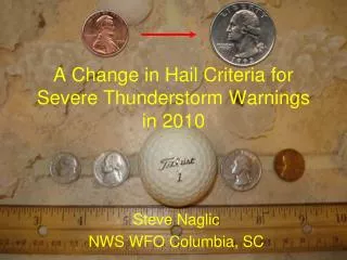
A Change in Hail Criteria for Severe Thunderstorm Warnings in 2010 Steve Naglic NWS WFO Columbia, SC
Motivation for the Change and Studies • NWS HQ changed the severe hail criteria from 0.75” (penny) to 1.00” (quarter) on January 4, 2010 • Most studies over past decade for the region are based on 0.75” • Surveys were mixed but research and climatology support the criteria change • Latest research indicates that significant damage (aside from crops) does not occur until hail size reaches 1 inch • A recent engineering study validates the increase in hail size threshold (Marshall et al.) • From a verification perspective, impact likelyon FAR (at least initially) • New criteria will reduce user complacency to numerous severe thunderstorm warnings • This should add more credibility to the end user • New thresholds and techniques are needed to accurately warn for the new 1” hail criteria
Oct 2006- Sept 2009 ER SVR Hail (.75”)by WFO The average frequency (%) of hail >= 1” is about 36% of all SVR hail reports (black line) in the last 3 years
Albany Study • Examined radar returns for each report of severe hail (0.75” or larger) from the major severe cases of hail from the summer of 2009 • June 15th and July 16th hail events • Compiled data and compared averages of each parameter that was examined
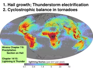
Parameters Studied 50 dBZ Echo Top 55 dBZ Echo Top 60 dBZ Echo Top 65 dBZ Echo Top Vertically Integrated Liquid (VIL) Storm Echo Tops (ET) Height of 50 dBZ Echo Top above -20° Celsius isotherm
Why dBZ heights? • In a warning situation, the height of the 50+ dBZ level in correlation with the -20° Celsius level is often examined. The increasing amount of height above this level increases the level of confidence of severe hail in a particular thunderstorm.
Issues with Hail Reports • Size is not always accurately measured • Spotters don’t always use rulers and some reports are from the untrained public • Location and time • Some locations and times listed on hail report may be estimated and some spotters may not have given their exact latitude and longitude • Tried to include only the reports that made sense based on radar for this study • Some hail reports may have occurred in unpopulated areas or in places where spotters were not available
Albany Results • The 50 dBZ ETs are in general about 10 kft above the -20° Celsius level • Average height is around 33 kft • The dBZ echo tops (for 50, 55, 60 and 65 dBZ) are about 6-7 kft higher in a severe over a non-severe storm based on the new criteria
Other Studies • Reflectivity Height vs -20C Height • WFO Pleasant Hill • Storm Top Divergence • WFO Omaha • Height of 50dBZ above Freezing Level • WFO Topeka
Height of Reflectivity Core • WFO Pleasant Hillfound a strong correlation with hail surpassing 1” diameter by comparing the height of the 55-60 dBZ cores vs height of the -20°C level.
Height of Reflectivity Core • WFO Des Moines found a strong correlation with hail surpassing 1” diameter by comparing the 50 dBZ height and the freezing level.
50 dBZ Echo Height Warning Criterion – WFO Des Moines FZLVL(AGL) = X Warning Criteria (AGL) =Y 6000 ft 15900 ft 6500 ft 16375 ft 7000 ft 17000 ft 7500 ft 18500 ft 8000 ft 19500 ft 8500 ft 20680 ft 9000 ft 21000 ft 9500 ft 22000 ft 10000 ft 23380 ft 10500 ft 24950 ft 11000 ft 26650 ft 11500 ft 28490 ft 12000 ft 30470 ft 12500 ft 32600 ft 13000 ft 34860 ft 13500 ft 37270 ft 14000 ft 39800 ft 14500 ft 42500 ft 15000 ft 45100 ft Non-Linear Eqn = 21611.52 + (-2.6304953*X) + (0.000280775468*X^2)
50 dBZ Echo Height Warning Criterion –WFO Topeka Here is a table showing the height of the freezing level and corresponding 50 dbz height needed for 1” hail.
WFO Greer Study 252 Events Analyzed (Oct ’04 thru Sept ‘09) 150 Retained for the study 99% of the events contained 55 dBz above the freezing level The 55 dBz echo extended to at least the -20 oC level for 93% of the events 86% of the events contained 60 dBz above the freezing level Of the events that contained at least 60 dBz above the FZL, roughly half extended to/above the -20 oC level 93% of the events occurred with FZL between 9 and 15 kft.
50 dBz Echo Top vs. Observed FZL Core Height (kft) FZL (kft)
55 dBz Echo Top vs. Observed FZL Core Height (kft) FZL (kft)
A Comparison of 50dBZ Heights FZL(ft) DesMoines Topeka Greer 8000 20kft 21kft 20kft 10000 23kft 25kft 24kft 12000 30kft 32kft 27kft 14000 40kft 39kft 30kft
Moving Forward Short term (Now until Dual-Polarization) Realize and understand the low frequency of 1” hail occurrence and use this to refine warning decision making/philosophy Engage in external outreach to educate and ensure a smooth transition for our customers Leverage (1”) hail detection techniques Need to adjust to fit environments (Eastern U.S. vs. the Plains) Identify favorable environments Mid Level Lapse Rate Anomalies, >= 6.0C/km good indicator
Dual-Pol Medium term (Duel-Polarization Era) Dual-pol to provide significant benefits in regards to 1” hail criteria change Polarimetric radars transmit and receive both horizontal and vertical polarization radio wave pulses. Therefore, they measure both the horizontal and vertical dimensions of cloud and precipitation particles. This additional information leads to improved radar estimation of precipitation type and rate. Able to detect hailstones rather than infer their presence based on current WSR-88D limitations
Polygons = better resolutionweather.gov/cae Three simultaneous tornadoes within line of severe thunderstorms • More specific • Increased clarity • Supports newdissemination technology County-Based Tornado Warnings 8 Counties under warning Almost 1 million people warned Storm-Based Tornado Warnings 70% less area covered ~600,000 fewer people warned
Questions? Steven.Naglic@noaa.gov