Download

1 / 23
230 likes | 427 Vues
Large, Sparsely Verified Severe Thunderstorm Warnings: Can we do better…and do we want to?. Eric Lenning and Ben Deubelbeiss NWS Chicago 2014 GLOMW. Motivation. Goal: An increased understanding of the types of severe weather systems (lines/clusters) that prompt large warnings.

E N D
Large, Sparsely VerifiedSevere Thunderstorm Warnings:Can we do better…and do we want to? Eric Lenningand Ben DeubelbeissNWS Chicago 2014 GLOMW
Motivation • Goal:An increased understanding of the types of severe weather systems (lines/clusters) that prompt large warnings. • Concern is large polygons with few if any reports: • Training? • Verification? • Population? • Radar sampling? • Workload? • Fear? • Conclusion:Environment + Radar Signatures Better Decisions
Narrow the Focus Consider “LARGE” SVR polygons (> 7000 sqkm). • Consider “SPARSELY VERIFIED” polygons (< 20% coverage). • Over 72% of large polygons from GL offices (139 of 191) were sparsely verified from 2008-2013.
LSR 15km Buffer Polygon Area: 12538 sqkm 5 LSRs and 21% Areal Verification • Polygon Area: 2088 sqkm • 1 LSR and 43% Areal Verification
Questions • Can we better distinguish between high-end and low-end lines or clusters of storms? • ** Use both environment and radar signatures ** • For lower-end lines/clusters, can we focus the warning area? • Are we willing to take a few hits to avoid over-warning? • Is there an SPS or IBW approach? • Is over-warning even a problem??? • Are we missing something else?
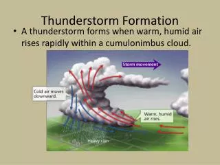
What do we know about damaging lines/clusters? • Wind is main concern with large polygons? • Favorable Environments • Marginal to large (sfc-based?) instability. • Marginal to large shear (0-6km or 0-3km?). • Cold pool potential, LFC height, wind/shear orientation… • Radar Characteristics • Fast motion, tight reflectivity gradients, rear-inflow jets, rotational couplets, MARC signatures, cell intersections, leading/trailing/parallel stratiform, bookend vortices, reflectivity tags….
FamiliarResearch Corfidi, 2003
MORE Recent Research Schaumann and Przybylinski, 2012
3km VGP and 0-3km Shear Vector 20080804 23 UTC 20120629 14 UTC
Result • 4-5 August 2008: • Warning 163 from 0018z-0130z • 68% areal verification • Widespread damage • 29 June 2012: • Warning 54 from 1544z-1645z • 8% areal verification (Still a HIT!) • ~60 mph gust, power lines down
Conclusions • Use large polygons based on morphology, not geography. • Large polygons best suited for derecho / bowecho types. • A large but ordinary line or cluster may warrant warnings, but only for smaller portions. • Environmental factors: • Orientation of 3km Shear Vector to lines of cells • Strength of 3km shear relative to cold pool