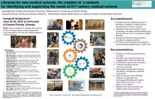
Accomplishments
The SIO Visualization Cluster has made significant advancements in rendering high-resolution seismic and satellite imagery. Utilizing a 10-node IBM PC Cluster and connecting to the OptIPuter network, it visualizes a 3D reflection image of a crustal magma chamber beneath the East Pacific Rise. Notably, the ARAD 3D dataset has been visualized through tools like GVU and Vol-a-Tile, enhancing accessibility and collaboration across institutions. Future initiatives aim to develop real-time 3D visualizations for USArray data and improve health monitoring of the network.


Accomplishments
E N D
Presentation Transcript
SIO OptIPuter Visualization Cluster • 10 node IBM PC Cluster driving two 9.2 million pixels IBM T221 displays. • Connects to the OptIPuter Southern California network.
Volume Rendering at SIO • SIO provided UIC and ISI with seismic volume dataset from the ARAD 3D experiment. • 800 x 800 x 1000 (32 bits) volume highlights the first 3D reflection image of a crustal magma chamber located beneath the East Pacific Rise. • GVU uses SIO VizCluster and renders to the monitor on the master node. • Vol-a-Tile uses SIO VizCluster and renders to IBM T221 displays. • Vol-a-Tile now runs data servers on UCSD’s Storage Cluster and renders on the SIO’s Visualization Cluster over the SoCal OptIPuter network. Figure 3:ARAD 3D volume visualized with Vol-a-Tile (EVL, UIC) Figure 1:ARAD 3D volume visualized with GVU (ISI, USC) Figure 2:GVU and Vol-a-tile on the SIO Visualization Cluster
High resolution imagery at SIO • IKONOS Satellite Imagery (courtesy of SpaceImaging.com). • 0.3 m San Diego aerial photography (courtesy of Brian Davis, USGS). • Mars Rover Mission Panoramic Image (courtesy of JPL,NASA). Figure 1:IKONOS satellite imagery combined with topography, bathymetry and seismic data in Incline Village, Lake Tahoe. Figure 2:USGS ortho-imagery combined with LIDAR data of the coastal bluffs in San Diego.
Accessing Data from Remote Cluster (JSOE cluster to SIO VizCluster) • Running multiple OptIPuter applications on SIO Cluster. • Retrieve scene file from storage cluster and display on IBM panels using Chromium. • Juxtaview on SIO cluster displays high resolution satellite imagery.
SIO Visual Objects Storage & Distribution • Scene files now stored on terabyte webserver on OptIPuter Storage Cluster for dissemination over OptIPuter network. • Two-fold increase in number of website visitors that downloaded the scene files.
Transferring OptIPuter technologies to other NSF Projects • RIDGE • Funded by RIDGE2K to develop visual objects of data collected with variety of methods in multiple disciplines. • GEON • Creating ‘scene’ files from geological and GIS data for San Diego and the Rockies. ROADNet: Mt. Laguna Camera • ROADNet • Generating high resolution time lapse movies on the SIO cluster from near real-time images captured by ROADNet sensors. • NASA Goddard (non NSF) • Level3 link between SIO and NASA to allow for e-science between the institutions.
Propose to build a 4 x 6 LCD tiled display driven by G5 Cluster • High resolution real time visualizations of USArray waveform data represented as 3D glyphs and combined with near real time camera images. • Provide health monitoring of entire network. USArray on the GeoWall 2
3D Tomography of Whole Earth Models • Project in progress to visualize the mantle models for the whole Earth and in particular the North American continent. • Need to visualize the process of tomography while still inverting for the model (Gabi Laske, IGPP) Figure 1:REM model combined with seismicity. Yellow blobs are isosurface representations of surface wave propagation. White dots represent earthquakes of magnitude greater than 4.0. Figure 2:Spherical representation of same data. Blue indicates positive values, where speed is high and mantle is cooler. Red indicates negative values, lower speeds and hotter mantle.