Advancing Watershed Management in Alberta: A GIS and ArcHydro Framework Overview
This poster presents an overview of the GIS data framework and hydrology tools under development to enhance watershed management in Alberta, inspired by the "Water for Life" sustainability strategy. It outlines the rationale, progress made, and examples demonstrating the utility of high-quality data. Key project milestones include the establishment of a GIS database utilizing ArcHydro, updates on DEMs, and the development of tools for watershed delineation and modeling. As seven Watershed Planning and Advisory Councils mature, integrated resource management plans will evolve to better address environmental pressures.

Advancing Watershed Management in Alberta: A GIS and ArcHydro Framework Overview
E N D
Presentation Transcript
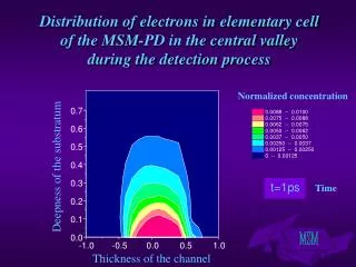
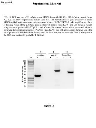
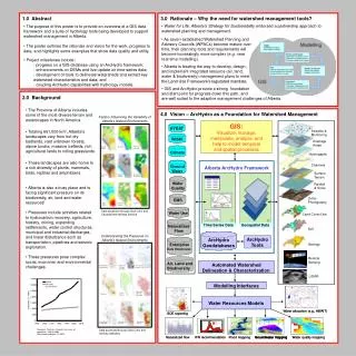
1.0 Abstract 3.0 Rationale – Why the need for watershed management tools? • Water for Life: Alberta’s Strategy for Sustainability endorsed a partnership approach to watershed planning and management. • The purpose of this poster is to provide an overview of a GIS data framework and a suite of hydrology tools being developed to support watershed management in Alberta. • The poster outlines the rationale and vision for the work, progress to date, and highlights some examples that show data quality and utility. • Project milestones include: • progress on a GIS database using an ArcHydro framework; • enhancements on DEMs and live update on time-series data; • development of tools to delineate watersheds and extract key watershed characteristics and data; and • coupling ArcHydro capabilities with hydrology models. • As seven established Watershed Planning and Advisory Councils (WPACs) become mature over time, their planning tools and requirements will become increasingly more complex (e.g. near real-time modelling). • Alberta is leading the way to develop, design, and implement integrated resource (air, land, water & biodiversity) management plans to meet the Land Use Framework’s legislated mandate. • GIS and ArcHydro provide a strong foundation and start point for progress down this path, and 2.0 Background are well suited to the adaptive management challenges of Alberta. • The Province of Alberta includes some of the most diverse terrain and waterscapes in North America. • Totaling 661,000 km2, Alberta’s landscapes vary from hot dry badlands, vast unbroken forests, alpine tundra, massive icefields, rich agricultural lands to rolling grasslands. • These landscapes are also home to a rich diversity of plants, mammals, birds, reptiles and amphibians. 4.0 Vision – ArcHydro as a Foundation for Watershed Management Factors Influencing the Variability of Alberta’s Natural Environments GIS: GIS: HYDAT Streams & Visualize, manage, Visualize, manage, Monitoring manipulate, analyze, and manipulate, analyze, and WISKI Drainage help to model temporal help to model temporal Areas and spatial processes and spatial processes Climate Hydrogaphy Channels Ground Alberta ArcHydro Framework Water Surface Terrain Water Rainfall • Alberta is also a busy place and is facing significant pressure on its biodiversity, air, land and water resources! • Pressures include activities related to hydrocarbon recovery, agriculture, forestry, mining, expanding settlements, water control structures, municipal and industrial discharges, and linear disturbance such as transportation, pipelines and seismic exploration. • These pressures pose complex social, economic and environmental challenges. Quality & Snow Ortho - EMS Photography Data accessed through GoA Citrix and Canada Internet Map Service Water Use Land Cover/Use Time Series Data Geospatial Data Time Series Data Geospatial Data Naturalized Soil Flow Understanding the Pressures on Alberta’s Natural Environments ArcHydro ArcHydro ArcHydro ArcHydro Enterprise Geology Tools Tools Geodatabases Geodatabases Data Warehouse Remote Sensing Air, Land and Biodiversity Automated Watershed Delineation & Characterization LiDAR Modelling Interfaces Water Resources Models Water allocation (e.g., AWAIT) Water allocation (e.g., AWAIT) SOE reporting SOE reporting 125 125 125 125 Natural flow Natural flow Natural flow Natural flow 100 100 100 100 Desktop (Hydrological) Desktop (Hydrological) Desktop (Hydrological) Desktop (Hydrological) SSRB IFN (Holistic) SSRB IFN (Holistic) SSRB IFN (Holistic) SSRB IFN (Holistic) 75 75 75 75 Discharge (m Discharge (m Discharge (m Discharge (m 50 50 50 50 Data accessed through GoA Citrix and ministry websites 25 25 25 25 12 12 12 12 16 16 16 16 20 20 20 20 24 24 24 24 28 28 28 28 32 32 32 32 36 36 36 36 40 40 40 40 44 44 44 44 48 48 48 48 52 52 52 52 Week of year Week of year Week of year Week of year Naturalized flow Naturalized flow IFN recommendation IFN recommendation Flood mapping Flood mapping Groundwater mapping Groundwater mapping Groundwater mapping Groundwater mapping Water quality mapping Water quality mapping
Water Budget Summary WISKI EDW TS 1 TS 5 TS 2 TS 3 TS 4 AB_ArcHydro AB_ArcHydro Applications Applications Watershed/Climatic Characteristics ArcHydro Geodatabases ArcHydro Tools MIKE SHE Integrated Hydrologic Modelling Simulated Hydrograph Channel Characteristics DHI (http://www.dhigroup.com) 5.0 AB-ArcHydro: Progress to Date • SDE geodatabases created for each of the 18 ‘major’ basins in the province (stream definition of 5 km2) • AB-ArcHydro is currently accessed two ways: • - Stand-alone Desktop ArcGIS • - Citrix thin-client Data Created in AB-ArcHydro Network • The geometric network Raster Data • The complex edge feature class • Raw DEM • The hydro junction of the network • Filled DEM The relationship of hydro junction and • • Flow direction catchment watershed • Flow accumulation • Stream Definition Daily Time Series Data • Stream Segmentation • Streamflow data • Catchment Grid • Water level data • Slope • Precipitation data • Slope greater than 30% • Snowfall data • Rainfall data Vector Data • Temperature data • Catchment • Sunshine data • Drainage Line • Snow pillow data • Adjoint Catchment • Humidity data • Drainage Point • Wind speed/direction data • Longest Flow Path For Catchment AB ArcHydro example for North Saskatchewan River Basin • Evaporation data • Longest Flow Path For Adj.Catchment • Evapotranspiration data • Centroid of Catchment • Natural flow data Data organized into 18 major basins Maidment, D.R. 2002. Arc Hydro – GIS for Water Resources, ESRI Press • Others 6.0 AB_ArcHydro: Current and Future Applications and Development Reconciling the Provincial DEM Live data links to Department databases TS 3 • Versions 1, 3 and 4 of AB_ArcHydro were each published with a time series (TS) database of hydrologic and climate data. Although comprehensive, the data was static in nature. Copies of time series were used to populate the ArcHydro database, meaning that the update of new information (and subsequent corrections to data) requires continued maintenance. The update process depends on resource needs that are not predictable or assured. • Version 2 of AB_ArcHydro was produced using the raster Provincial 100m DEM plus high quality hydrography (stream network) that was burned into the DEM. • When a Hydrocorrected 25m DEM became available it was used for Version 4 of ArcHydro. It was presumed that since the DEM had been resampled* with the drainage network taken into account, this would be an improvement over ArcHydro 2. (*the 25m grid size was resampled from the 100m DEM, by interpolation) • However, user acceptance testing of ArcHydro 4 data set is ongoing as several issues have been identified with the Hydrocorrected Provincial 25m DEM layer. For the moment, ArcHydro 2 remains the endorsed version for watershed delineation purposes. TS 2 TS 5 TS 1 TS 4 Others • While this is workable, in principle it is preferred to reference a single true source of original data, rather than rely on standalone replications. A better solution would be to develop permanent and open data connections to Department information systems (like the WISKI time series manager, or the Enterprise Data Warehouse/EDW) to ensure the most correct and up-to-date information is always presented by AB_ArcHydro. Alberta Desktop Method Application: Computations and Report Coupling to Hydrologic Models Example: Drainage areas derived for WSC Sub-regions using pour points and the Alberta 25m Hydrocorrected DEM (colour polygons), as compared with prior drainage boundary delineations (black lines) The “Alberta Desktop Method” Recommendation for Environmental Flows uses historical natural flows to come up with an instream flow recommendation that is fully protective of the aquatic environment and in the absence of reach specific studies. It is typically applied on a weekly time step, meaning that there are 52 recommendations based on the weekly flow duration curve and computed environmental baseflow for that week. This results in fairly routine but intensive computations, and has been automated within an Application that functions with the AB_ArcHydro data. Areas circled in red indicate places where the hydrocorrected DEM is at significant variance to existing watershed delineations. In both cases this has been tracked to likely DEM errors – canals not being removed from the terrain – resulting in portions of the lower Bow draining south to Oldman (pink) or north to Red Deer (green). A major goal for establishing a single source of hydrology-related time series and spatial data is to make model development, calibration and operation quicker and easier. Models that can process ArcHydro-compliant databases will be able to seamlessly interface with data sources. It is expected that ArcHydro databases and tools will support models that estimate water budgets, compute natural flows and simulate hydrographs in ungauged basins. Testing of the MIKE SHE model for several pilot projects has been undertaken (MIKE SHE does not yet directly support ArcHydro but was planning to develop that functionality.) Word Document Summary Report • A process for reconciling identified variances and known issues arising between different topographic-based datasets needs to be developed. This is a broader initiative than just ArcHydro. • It is recognized that no data set is without issues; but migration toward a single, adequately maintained and continually updated topographic data set for routine watershed delineations using common digital methods and tools would be ideal. Hydrologic Stats/ Summary Charts Weekly Flow Recommendations Historical Availability Matrix