Download
1 / 32
330 likes | 440 Vues
This research focuses on developing an Excess Flood Vulnerability Index (EFVI) and a system to estimate flood vulnerability, addressing shortcomings in current flood control safety measures. The study includes analysis of the Flood Damage Index (FDI), Human Casualty Index, Property Damage Index, and Inundation Area Index to enhance the understanding of flood vulnerability factors. The research utilizes components such as climatic, socio-economic, and flood protection aspects to determine vulnerability and hazard indices. By weighting various indicators and employing the EFVI and Excess Flood Vulnerability Estimation System (EFVS), this study aims to enhance flood risk assessment capabilities.

E N D
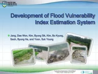
Development of Flood Vulnerability Index Estimation System • Jang, Dae Won, Kim, Byung Sik, Kim, Bo Kyung, Seoh, Byung Ha, and Yoon, Suk Young
Index Background 1 Objectives of the study 2 3 Excess Flood Vulnerability Index Excess Flood Vulnerability estimation System 4 5 System Demonstration
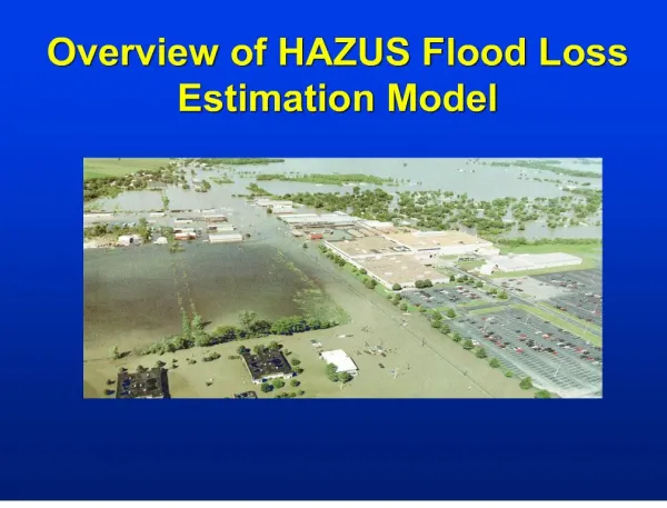
Background Rainfall Intensity & Flood Damage in Korea Rainfall Intensity over 50mm Damage trend Damage(billion $) frequency Casualty Property damage Human Casualty year • For the last thirty-year period, rainfall intensity is increased • Consequently, property damage has increased dramatically. • However, human casualty has decreased Flood Damage
Paradigm change Classification of the river in Korea: 1. National River (1st Class river) 2. Regional River (2nd Class river) 3. Small River(3rd Class river) National river: Design frequency (200year) Urban area : 500year Agricultural area: 50year Regional river: Design Frequency (100year) Small river: Design Frequency (50year) Wetland area : 10year River Flood control considering regional unit
Objectives of the study • Korea selects flood control safety level based on the estimationof Potential Flood Damage; PFD) • But PFD just show overall safety level for flood damage in mid and large basins. • So, PFD can not correspond properly to the flood It fails to suggest an actual solution to cope with floods • This research will improve the limitations of PFD. • So, we developed Excess Flood Vulnerability Index(EFVI) for the analysis about vulnerability that did not considered in PFD • And also we developed Excess Flood Vulnerability estimation System(EFVS) that can evaluate the vulnerability.
Analysis of FDI Application (Anseong-Cheon basin) System Construction developed Vulnerability Index Analysis of PFD Procedure of the study
Potential Flood Damage (PFD) Potential Flood Damage (PFD) • PFD was developed and used in National Water Resources Planning in Korea for analyzing flood potential in the regional unit or concerned area of the river basin and for the decision making for the priority of investment for flood prevention project • PFD = f (Flood Potential, Risk) • Flood Potential = f (Population, Property, Urbanized Ratio, Infra-structure) • Risk = f (Flood Damage, Design Rainfall, Improved Ratio of Levee, Dams and Reservoirs, Runoff)
Potential Flood Damage (PFD) • The regions of class A of PFD has increased from 27 to 35 (30% increase) • Southeast coastal regions and central regions need to be invested with higher • priority for the flood prevention measures.
Standardized Human Casualty Index (SHCI) = std (N. of Human casualties of unit area / Population of unit area) Standardized Property Damage Index (SPDI) = std (Value of damaged property of unit area / Value of total property of unit area) Standardized Inundated Area Index (SIAI) = std (Inundated area of unit area / Total area of unit area) FDI SHCI SPDI SIAI Flood Damage Index (FDI)
Flood Damage Index for an area of Han river Basin (1982~2003) 3 Property Damage Index Inundation Area Index Casualty Index Flood Damage Index 2 1 0 1985 1995 1990 1982 2000 PFD is widely used for representing the degree of potential of flood damage. FDI just corresponds to property damage index. However we have difficulty in the use for flood defense measures or projects because index does not correspond to the flood frequency .
Excess Flood Vulnerability Index(EFVI) • We considered the climatic, Hydro-geological, Socio-Economic, flood Protection • components and developed EFVE and EFVS
Critical Facility Erosion Risk Area Climatic Flood Risk Area Vulnerability Index Design Hazard Index Design Environmental Inundation map Social Hazard risk area Economic damage magnitude Basin Slope Mitigation • Benouar & Mimi(2001) • Risk = Hazard x Vulnerability divided by Disaster Management • Vulnerability is defined as the weakness/strength of the element at risk What kinds of indicators do we have for Vulnerability and Hazard indices?
Determine weighting values of indicators • Weighting values of the indicators were decided by conducting a survey to the specialists in industrial, academic, and research fields • We use AHP analysis for determining weighting values (Saaty, 1980)
Climatic Components Socio-Economic components Hydro-Geological components Flood Protection Components P S G C EFVI i / max Weight Estimation of EFVI 1 4 4 0.25 1.0 1.0 4 1 2 0.25 1 0.5 2.0 Population 2 4 2 0.75 0.25 1.5 0.5 slope 1 1 2 0.5 1.0 0.5 1.0 rainfall 2.5 5.5 3.0 3.5
STATE EFVI EFVS (Excess Flood Vulnerability estimation System) System development process 1step User Demand analysis EFVS 2step System design 3step GIS DB design 4step Analysis module 5step EFVS 6step System integration
Climatic vulnerability estimation System - STAtistical diagnostic Tool for Extreme weather[STATE] STATE analysis results • Heavy rainfall threshold • Greatest 5-day rainfall • Average wet-day rainfall • Longest dry period • Heavy rainfall proportion • Heavy rainfall days • Hot-day threshold • Cold-night threshold • Frost days • Longest heatwave
Pilot Study Area Anseng-cheon basin Drainage Area : 1,699.6km² River Length : 66.4km Average Annual Precipitation : 1,225mm July, August, September Rainfall (total) : 670mm
EFVS [input weighting values] Input weighting value EFVI =C+G+S-P Hydro-geological Climatic EFVS Socio-economic Protection
EFVS [the grade point of a small basin] Grade for vulnerability We can see grade point for the following 4 components Hydro-geological Climatic EFVS Socio-economic Protection
EFVS [Estimationof Runoff coefficient] Hydro-geological analysis - Basin slope - Runoff coeff - Natural Hazard Risk Area - Erosion Risk Area - Sea Level Rise Zone - Flood damage magintude Hydro-geological Climatic EFVS Socio-economic Protection Infomation 도시화율이 높을 수록불투수율이 높음
EFVS [Hazard Risk Area] Hydro-geological analysis - Basin slope - Runoff coeff - Natural Hazard Risk Area - Erosion Risk Area - Sea Level Rise Zone - Flood damage magintude Hydro-geological Climatic EFVS Socio-economic Protection
EFVS [Estimation of Flood damage magnitude] Hydro-geological analysis - Basin slope - Runoff coeff - Natural Hazard Risk Area - Erosion Risk Area - Sea Level Rise Zone - Flood damage magnitude Hydro-geological Climatic EFVS Socio-economic Protection
EFVS [Population density] Socio-Economic analysis - Density of population - Financial ratios Hydro-geological Climatic EFVS Socio-economic Protection
EFVS [Financial ratios] Socio-Economic analysis - Density of population - Financial ratios Hydro-geological Climatic EFVS Socio-economic Protection
EFVI and PFD are showing similar results Result Comparison of PFD and EFVI estimated from EFVS EFVI PFD
Basin characteristic Vulnerabilityinformation Future Research Plan EFVS– Second Stage (basin characteristics)
EFVS– Second Stage (facility-pump station) Critical Facility (Critical Facility Analysis –Pump station) Hydro-geological Climatic EFVS Socio-economic Protection
EFVS– Second Stage (Inundation of the basin) Inundation Map (Anseong-cheon basin) Hydro-geological Climatic EFVS Socio-economic Protection
What kings of flood Defense countermeasure Should we construct in this basin ? EFVS– Second Stage (decision of flood defense measures)
Thank You ! Q & A