Download
1 / 36
360 likes | 574 Vues
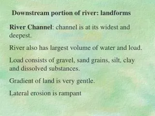
Downstream portion of river: landforms. River Channel : channel is at its widest and deepest. River also has largest volume of water and load. Load consists of gravel, sand grains, silt, clay and dissolved substances. Gradient of land is very gentle. Lateral erosion is rampant.

E N D
Downstream portion of river: landforms River Channel: channel is at its widest and deepest. River also has largest volume of water and load. Load consists of gravel, sand grains, silt, clay and dissolved substances. Gradient of land is very gentle. Lateral erosion is rampant
Downstream portion of river: landforms River Valley: wide and flat bottomed. Lateral erosion by river and weathering and erosion helps to widen valley. Work of river: lateral erosion, especially along the concave banks of meanders. Main work is deposition.
Downstream portion of river: landforms A) Flood plains and levees Cross-section of a floodplain
Downstream portion of river: landforms • A) Flood plains and levees • a floodplain is a gently sloping/level plain built up of successive layers of alluvium deposited by a river in times of flood. • During heavy rainfall, amount of water in the river channel increases. • As the river continues to rise, the water will cover any adjacent flat land.
Downstream portion of river: landforms • A) Flood plains and levees • land susceptible to flooding in this manner is known as the floodplain. • Once out of the channel, water encounters more friction because of increased wetted perimeter. • This reduces speed of water, resulting in deposition.
Downstream portion of river: landforms • A) Flood plains and levees • When a river overflows its bank, the larger and coarser materials will be deposited first. • This forms a small, natural embankment alongside the channel. • This embankment is called a levee. • Smaller sized and finer materials will be deposited further away from the river.
Downstream portion of river: landforms • A) Flood plains and levees • The thin veneer of silt deposited by each flood increases the fertility of the floodplain. • Successive flooding causes the floodplain to build up in height. • The floodplain may also be made up of materials deposited as point bars on the inside of meanders.
Downstream portion of river: landforms A) Flood plains and levees Stages in the formation of flood plains and levees
Downstream portion of river: landforms A) Flood plains and levees Note: although flood plains and levees are better developed in the lower course of the river, they can also occur between the upper course and lower course.
Downstream portion of river: landforms B) Ox-bow lakes. • horse-shoed/crescent-shaped lake.
Downstream portion of river: landforms B) Ox-bow lakes. • river in the lower course meanders widely across the low-lying floodplain. • Lateral erosion and undercutting occur on the concave banks where stream flow is fastest.
Downstream portion of river: landforms B) Ox-bow lakes. • deposition occurs on the convex banks because of slack water flow. • Over time, the meander becomes very pronounced (a) • Two neighbouring concave banks will get closer.
Downstream portion of river: landforms B) Ox-bow lakes. • narrow neck of land between the two neighbouring concave banks will eventually be cut through either by lateral erosion on the concave banks or strong currents during a flood.
Downstream portion of river: landforms B) Ox-bow lakes. • a new straighter river channel is created through which the river now flows. • An abandoned meander loop called a cut-off is formed (b).
Downstream portion of river: landforms B) Ox-bow lakes. • deposition can now take place next to the river bank. • When enough deposition has taken place, the cut-off is sealed off from the main river channel. • An ox-bow lake is now formed. (c)
Downstream portion of river: landforms B) Ox-bow lakes. Note: An ox-bow lake may not be a permanent feature as the water may dry up and it will be then filled with sediments and vegetation.
Downstream portion of river: landforms • C) Braided streams • when river’s level falls rapidly, competence and capacity of the river is compromised. • Load will be deposited. • These deposits will obstruct he flow of the river and cause it to split or divide into smaller channels. • The river will divide into a series of diverging and converging segments.
Downstream portion of river: landforms C) Braided streams
Downstream portion of river: landforms C) Braided streams
Downstream portion of river: landforms • C) Deferred Streams • streams on the flood plain may not be able to join the main river directly because of the presence of levees. • They end up flowing down the valley and joining the main river further downstream. • These are known as deferred streams.
Downstream portion of river: landforms C) Deferred Streams
Downstream portion of river: landforms • E) Deltas • flat alluvial depositional plain produced by a river when it enters calm water such as a lake or tideless sea.
Downstream portion of river: landforms E) Deltas Conditions for formation: 1. Active erosion along the course of the river. 2. River flows across resistant rocks so that the weathered material and eroded rock particles can add on to the load. 3. Tributaries are present to add to the load.
Downstream portion of river: landforms E) Deltas Conditions for formation: 4. There are few/no large lakes along the river to trap the load. 5. Gentle offshore gradient with shallow water. 6. Coastal waters are calm/tides are weak - no strong currents/waves to remove deposited sediments.
Downstream portion of river: landforms E) Deltas Conditions for formation: 7. Removal of sediments is slower than deposition. 8. Climate of are favours fast growth of vegetation that binds and stabilises the sediment.
Downstream portion of river: landforms • E) Deltas • Formation process: • When a river enters the sea, it mixes with the surrounding water and its speed is reduced. • The salty seawater causes the silty particles to aggregate/accumulate into larger particles (flocculation).
Downstream portion of river: landforms • E) Deltas • Formation process: • As these deposits are heavier, they are deposited first at the river’s mouth. • The main river channel will be silted and blocked up. • River overflows and splits into many small channels called distributaries.
Downstream portion of river: landforms • E) Deltas • Formation process: • As layers upon layers of alluvial materials are deposited, a platform of alluvium is built up and rises above the water. • This flat alluvium is called delta.
Downstream portion of river: landforms E) Deltas Formation process:
Downstream portion of river: landforms • E) Deltas • Formation process: • The distributaries formed will build up their own levees. • Vegetation (mangroves) that later grows on the alluvium helps to bind the alluvial deposits together and stabilizes the delta. • Deltas typically have triangular shapes.
Downstream portion of river: landforms • E) Deltas • Formation process: • As the delta grows larger and seawards, it will eventually merge with the river’s flood plain and no longer possess the appearance of a delta.
Downstream portion of river: landforms E) Deltas Types of deltas
Downstream portion of river: landforms E) Deltas Types of deltas: Arcuate delta • triangular/fan-shaped. • water enters the sea through many distributaries. • formed when alluvial deposits are evenly spread out. • Longshore currents help to form spits and lagoons at the mouths of the distributaries • Eg.: Nile delta
Downstream portion of river: landforms E) Deltas Types of deltas: Bird’s foot delta • has distributaries that extend far into the water. • Formed when river discharge is high and load is enormous. • Sediments deposited far exceeds those removed by tides and currents. • Eg.: Mississippi delta
Downstream portion of river: landforms E) Deltas Types of deltas: Estuarine delta • sediments are deposited in a long narrow submerged estuary. • Delta does not usually grow beyond the general coastline because sediments deposited outside the estuary would be washed away by waves and currents. • Eg.: Seine delta
Downstream portion of river: landforms References: Chong, M. (2001) Aspects of Physical Geography, Singapore Pekoe Books. Waugh, D (2000) Geography – An Integrated Approach, UK: Nelson