Download
1 / 1
20 likes | 168 Vues
Urban Planetary Boundary Layer Height Detection From LIDAR Measurements in New York City. The LIDAR System. Abstract. PBL-heights observed by CCNY-LIDAR.

E N D
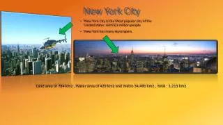
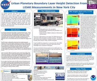
Urban Planetary Boundary Layer Height Detection From LIDAR Measurements in New York City The LIDAR System Abstract PBL-heights observed by CCNY-LIDAR The Planetary boundary layer (PBL) height measurements are important in improving prediction of the local air quality and weather-climate related research. LIDAR is one of active remote sensing tools to measure PBL-height through observing aerosol vertical distribution. In this study, we make the LIDAR observations over one month period ( June 2012 to July 2012) in New York City, and the PBL-heights are derived with the wavelet transform technique (WCT). We compared the gradient method and WCT method for deriving PBL-heights which generally show good agreement. The cases analysis show the PBL-height variation day-by-day in the NYC-Urban area. To obtain the Planetary Boundary Layer (PBL) height, we were using two MATLAB programs to process the LIDAR data. The first program used the Wavelet method; we were able to obtain the PBL height for all of the days that we ran LIDAR clearly although we did have to change the height that the program could use to detect the PBL height depending on the specific date because the program would detect the clouds and mark both the PBL and cloud measurements as the PBL height. The second program used the gradient method to detect the PBL height; this program was more difficult to work with. The gradient method uses the maximum slope to detect the PBL height; this proves to be a problem because clouds have a larger slope because the particles in clouds are larger than aerosols that are located below the PBL height. The images on the side in order are (a) an image directly from the LIDAR, (b) an image after the wavelet analysis was run through MATLAB, and (c) an image generated by MATLAB with the Gradient method. As can be seen through image (a) the day is clear except for a layer of aerosols seen above the PBL height which measures about 1 Km. The PBL height is measured correctly in image (b), although in image (c) the PBL height measured correctly by the gradient method but then it picked up the layer of aerosols above the PBL. The Planetary Boundary Layer (PBL) is essentially what it says- ‘a layer that bounds the planet,’ specifically this planet, Earth. The PBL is one of two layers that forms the troposphere, the PBL begins at ground level and extends upwards and then meets what is known as free atmosphere. Since we exist within the PBL its study and research is important to all, our research is primarily concerned with the diffusion since it is the aerosols that we use to detect the height of the PBL. The PBL height is affected by vertical and horizontal mixing and diffusion, each of which directly influence on the PBL. The PBL is the lowest part of the atmosphere and its behavior is directly influenced by its contact with the ground. The PBL responds to the vertical and horizontal forces in a timescale of an hour or less. The PBL in and around urban settings are easier to detect based on the type of aerosols dispersed into the air from the ground. The representation of the PBL height in atmospheric models relies on the turbulent nature of the air. There have been different methods used to detect the height of the PBL; we used an active remote sensing instrument called LIDAR with interpretive software in conjunction with MATLAB to view the results of the outputted data from the LIDAR. The LIDAR works on a principal that sends out laser beams and the signals are scattered once they met particles in the air. The concentration, size and chemical composition of particles will determine the scattered signal intensity. The so called mixed layer, where the PBL and free atmosphere meet, has a higher moisture content and greater aerosol content which in turn causes more scattering of the laser light hence the detection of the height of the PBL. The LIDAR has an accuracy of within tens of meters; in urban areas we can use a higher signal to noise ratio and also a high laser output for better results. • The process for the LIDAR to gather measurements can be put simply into three steps. • Sending light (laser) to the atmosphere. • Recording the light scattered by the atmosphere, as a function of time. • Convert the time of flight to distance (1 millisecond to 150 kilometers). • This process is light detection and ranging. The LIDAR allows for the observation of the atmosphere at ambient conditions. The LIDAR is able to detect basic atmospheric variables of pressure, temperature, humidity, wind, aerosols, clouds, and other trace gases. • To put the LIDAR into perspective, in comparison with radar, LIDAR wavelengths are measured in nanometers while radars contain wavelengths from centimeters to kilometers. • The aerosols detected in the atmosphere by the LIDAR system are described as suspended small particles in a gas and solid phase. The particles may be liquid, solid or both. • Below are examples of aerosol sources. Introduction Conclusion Through our research we were able to determine that using the program with the Wavelet method gives a more accurate PBL height than when using a program with the Gradient method. Our findings showing that the Wavelet method determines the PBL height with a higher accuracy are similar to previous research findings. Through using Radiosonde data to determine the PBL height we also observed that both the LIDAR system and the PBL height obtained through the Radiosonde data were similar. Future Works Contributors Kelvin Quarcoo High School Teacher Thaelis Suriel Undergraduate StudentJose Ovalle High School student Advisors: Prof. Fred Moshary Ph.d (PI) Yonghua Wu Ph.d Dr. Lenell Allen, National CIPAIR Project Manager Dr. Nieves Angulo, CUNY CIPAIR Mentor Dr. Claude Brathwaite, NYC LSAMP Project Administrator • To extend the hours in which the LIDAR data is collected from 10 A.M – 6 P.M to 8A.M – 8 P.M, to be able to compare results with Radiosonde data accurately. • To give the LIDAR the ability to detect the PBL height directly instead of having to use a separate program. • The LIDAR system can be used to help meteorologists as well, by allowing it to perform like the Radiosonde. Sponsors National Aeronautics and Space Administration (NASA) NASA Curriculum Improvements Partnership Awards for the Integration of Research (NASA CIPAIR) NASA Goddard Space Flight Center (GSFC) NASA Goddard Institute for Space Flight Studies (GISS) NASA New York City Research Institute (NYCRI) National Oceanic and Atmospheric Administration (NOAA) NOAA Cooperative Remote Sensing Science and Technology center (NOAA Crest) HOSTOS Community College of CUNY The City College of New York (CCNY)