Download
1 / 7
70 likes | 183 Vues
This dataset provides an extensive overview of urban and economic statistics for the Municipality of Rome. It includes spatial data on traffic zones, land use classifications, and development types gathered from sources like the Municipality of Rome and CNR. Additionally, it presents detailed household demographics from ISTAT, mobility patterns based on traffic data, and employment statistics from the Census on Economic Activities. Valuable insights into land use, economic value, and housing information contribute to informed urban planning, development, and policy-making in Rome.

E N D
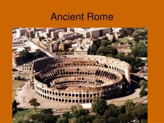
Rome UrbanSim: data and sources Barbara Staniscia Sapienza University of Rome
Spatial data • Traffic zones: STA-Municipality of Rome • Land use: Corine - CNR • Development types: Municipality of Rome • City Masterplan: Municipality of Rome
Households data • Households control total: ISTAT, Population Census, 1991, 2001 • Households: ISTAT, ECHP • Households relocation rate: ISTAT, ECHP • Ethnic origin: ISTAT
Mobility data • Travel data on traffic zones: STA – Municipality of Rome
Economic data • Employment control totals: ISTAT, Census on Economic Activities, 1991, 2001 • Annual employment control totals: ISTAT, Census on Economic Activities, 1991, 2001 • Jobs: ISTAT, Census on Economic Activities, 1991 • Job relocation rates ISTAT, Workforce Survey
Land economic use and value • Floorspace per job unit: CRESME • Land value: BIR • Residential land value and improvement value: Municipality of Rome and BIR • Industrial, commercial and governmental improvement value: Municipality of Rome and BIR
Buildings and houses • Housing units: ISTAT • Year built: Municipality of Rome