Download
1 / 7
80 likes | 1.21k Vues
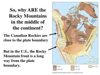
So, why ARE the Rocky Mountains in the middle of the continent?. The Canadian Rockies are close to the plate boundary But in the U.S., the Rocky Mountain front is a long way from the plate boundary.

E N D
So, why ARE the Rocky Mountains in the middle of the continent? The Canadian Rockies are close to the plate boundary But in the U.S., the Rocky Mountain front is a long way from the plate boundary.
When 2 continents collide, they trap mountains between them, as in the Himalayas, Urals, and Alps But the Rockies don’t have either one Marked by andesitic volcanoes on the overriding plate and an ophiolite where the ocean closed up
North America’s Cordilleran mountain belt is made of accreted terranes These exotic crustal fragments were added to the continent during the Triassic, Jurassic, and Early Cretaceous, - before the Rocky Mts. formed.
The Rocky Mountains formed in the Late Cretaceous to Early Tertiary Parts of the craton were uplifted along steep reverse faults whose cause is not well understood. The plate boundary was closer than today, but still relatively far away.
The Rocky Mountains formed during the Late K to Early T Magmatism and volcanism during the Laramide Orogeny were weak and widespread. This suggests that other causes than simple subduction were important.
The Basin and Range Province formed in Late Tertiary/Quaternary The crust heated up and thinned over a broad region. Normal faults, horsts, and grabens created scattered uplifts with basins between them. Extension widened the continent to 3 or 4 times its original width.
WHY? One suggestion is that migration of triple junctions along the Cascadia Trench changed the stress field and caused the extension Another factor probably was migration of the continent across a hot spot (Columbia River, Snake River, and Yellowstone Plateaus) - weakening the crust by heating