Download
1 / 25
250 likes | 473 Vues
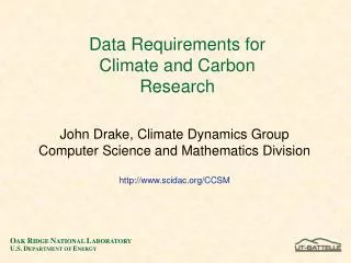
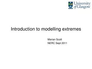
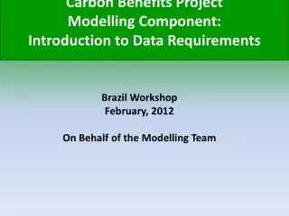
Carbon Benefits Project Modelling Component: Introduction to Data Requirements. Brazil Workshop February, 2012 On Behalf of the Modelling Team. Simple Assessment. Detailed Assessment. Dynamic Modelling. Toolkit advisor. Project Description Module. Guidance Module.

E N D
Carbon Benefits Project Modelling Component: Introduction to Data Requirements Brazil Workshop February, 2012 On Behalf of the Modelling Team
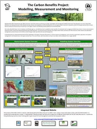
Simple Assessment Detailed Assessment Dynamic Modelling Toolkit advisor Project Description Module Guidance Module Assessment Tools Measurement Module Remote Sensing Ground-based Measurement Protocol Module Socioeconomic Tools Project Information Module MRV Module REDD & A/R Carbon Benefits Reporting Module
Goal for this Session Help workshop participants become familiar with the types of land use and management data required to calculate the Carbon / Greenhouse Gas Balance in the CBP Modelling Pages. • Outline • Review the need for Comprehensive Greenhouse Gas Inventories • Definition of Terms and Units • Data Required
Presentation Outline • Outline • Review the need for Comprehensive Greenhouse Gas Inventories • Define of Terms and Units • Show Data Requirements for Different Land Use Systems
Why Do a Comprehensive Greenhouse Gas Inventory? • Many development agencies and NGOs, including the Global Environmental Facility (GEF) wish to know the GHG consequences of projects they are supporting. • Emerging tools focus almost exclusively on forest biomass (for REDD, etc.) • Comprehensive GHG flux assessment is necessary to assess the Net GHG benefit if land use & management changes.
Definition of Terms • IPCC: Intergovernmental Panel on Climate Change • Polygon: A spatial area associated with project activities, generally larger than ~10 ha in size, with clearly defined boundaries. • Point: A spatial area associated with project activities, generally less than ~10 ha in size. • Project Activity Area / Intervention Area: A point or polygon where sustainable land management project interventions are expected to occur.
Definition of Terms, continued • Carbon Benefits: We interchangeably use the term carbon benefits and greenhouse gas (GHG) benefits in the Carbon Benefits Program. • GHG Flux: Emission of greenhouse gases from land use practices is shown as a positive (+) flux value, whereas sequestration of carbon is shown as a negative (-) flux value. All flux is expressed in CO2 equivalents (CO2e).
Units, etc. • Area: hectares • Carbon / Greenhouse Gas flux: Mg (tonnes) CO2e • Time frame: 1 to 20 years • Greenhouse Gases included in the inventory: • Carbon Dioxide (CO2) • Methane (CH4) • Nitrous Oxide (N2O)
CBP Modelling System What Data are Required? Details on Land Use and Management Activities that will be changed as part of the project.
CBP Modelling System Data Requirements - Example • Example from Western Kenya: ~50,000 hectares in the Yala River watershed • Decrease Soil Erosion • Reduce Deforestation • Improve Food Security • Diversify Agricultural Economy
CBP Modelling System Data Requirements - Example • Existing Land Use and Management • Annual Cropland: ~35,000 ha • Livestock: Unknown number of cattle, shoats, swine, poultry • Forestry / Deforestation: ~8,000 ha, loss of ~250 ha per year • Perennial Cropland: ~1,000 ha • Sustainable Land Management Interventions: • Introduce Agroforestry into Annual Cropland: 400 households • Improved Livestock Breeds: targeted households • Afforestation and stop Deforestation: 100 ha/yr • Diversify Perennial Cropland Systems: 500 ha
CBP Modelling System Data Requirements - Example Include only the Land Use and Management Activities that have or will change as part of the Sustainable Land Management Project. --- This will allow you to assess the Carbon & Greenhouse Gas Benefits of the project.
CBP Modelling System Data Requirements for Forestland • Locations of native forest or plantations, extent of interventions (ha) • Forest / Plantation System Type • Age Range (<= 20 years or > 20 years) • Natural Losses: • Fire (%/year) • Wind (%/year) • Pest/Disease (%/year) • Other (drought, etc.) (%/year) • Timber Harvests (m3/year) • Fuelwood Gathering (m3/year)
CBP Modelling System Data Requirements for Grassland • Locations of Grassland Systems, extent of interventions • Grassland Condition (Improved, Nominal/Native, Degraded) • Fertilizer Applications – Amount of Fertilizer, % Nitrogen • Burn Frequency • Silvopasture system type (if applicable) • Silvopasture Tree Type • Silvopasture Tree Age Range (<= 5 years, 5-8 yrs, 8-30 yrs, > 30 yrs) • Natural Losses: • Fire (%/year) • Wind (%/year) • Pest/Disease (%/year) • Other (drought, etc.) (%/year) • Timber Harvests (m3/year) • Fuelwood Gathering (m3/year)
CBP Modelling System Data Requirements for Perennial Cropland • Locations of Perennial Cropland Systems, extent of interventions • Crop Type • Fertilizer Applications – Amount of Fertilizer, % Nitrogen • Tree Age Range (<= 5 years, 5-8 yrs, 8-30 yrs, > 30 yrs) • Natural Losses: • Fire (%/year) • Wind (%/year) • Pest/Disease (%/year) • Other (drought, etc.) (%/year) • Timber Harvests (m3/year) • Fuelwood Gathering (m3/year)
CBP Modelling System Data Requirements for Annual Cropland • Locations of Annual Cropland, extent of interventions • Cropping System / Crop Rotations • Management Status – Improved? (Fertilization, irrigation, cover crops, legume in rotation, use if high-yielding varieties) • Tillage System (Full, Reduced, No tillage) • Fertilizer Applications – Amount of Fertilizer, % Nitrogen • Residue Management (Burned, Collected, Grazed, Retained)
CBP Modelling System Data Requirements for Agroforestry • Locations of Annual Cropland, extent of interventions • Cropping System / Crop Rotations • Management Status – Improved? (Fertilization, irrigation, cover crops, legume in rotation, use if high-yielding varieties) • Tillage System (Full, Reduced, No tillage) • Fertilizer Applications – Amount of Fertilizer, % Nitrogen • Residue Management (Burned, Collected, Grazed, Retained) • Natural Losses: • Fire (%/year) • Wind (%/year) • Pest/Disease (%/year) • Other (drought, etc.) (%/year) • Timber Harvests (m3/year) • Fuelwood Gathering (m3/year)
CBP Modelling System Data Requirements for Settlements • Locations of Settlements, extent of interventions (# of Trees or Crown Cover %) • Tree Types • Tree Age Range (<= 20 years or > 20 years) • Natural Losses: • Fire (%/year) • Wind (%/year) • Pest/Disease (%/year) • Other (drought, etc.) (%/year) • Timber Harvests (m3/year) • Fuelwood Gathering (m3/year)
CBP Modelling System Data Requirements for Wetlands • Area extent of Wetlands
CBP Modelling System Data Requirements for Livestock • Number of Livestock (Non-Dairy Cattle, Dairy Cattle, Swine, Goats, Sheep, Poultry, Camels, Buffalo, Horses, Mules and Asses, Rabbits and other small mammals • Number of months during the year Livestock are present in the Project Activity Area • Percent of Manure Management Systems utilized (Pasture/Range/Paddock, Dry Lot, Anaerobic Lagoon, Anaerobic Digester, Burned for Fuel).
CBP Modelling System Project Worksheet Example – Forestland
CBP Modelling System Project Worksheet Example - Livestock
Project Scenario Example Cropland Improvement, Introduction of Agroforestry • Project goal: • Reduce soil erosion • Improve food security • Diversify cropping systems to include Agroforestry • Initial Condition: 10,000 ha continuous maize intercropped with legume, low fertilization. • Baseline Scenario: Situation in the initial condition continues. • Project Scenario: • 5,000 maize-legume intercrop rotated with pasture and improved fertilization. • 5,000 ha agroforestry system with maize-legume intercrop.
Project Scenario Example Afforestation, Rangeland Improvement • Project goal: • Reduce soil erosion • Improve food security • Reduce deforestation, replant deforested areas. • Initial Condition: Deforestation rate of 250 ha/yr, deforested areas becoming degraded rangeland. • Baseline Scenario: Situation in the initial condition continues. • Project Scenario: • 250 ha/yr of deforested areas replanted with native species. • Degraded rangeland improved.