Download
1 / 30
300 likes | 413 Vues
This interim review presents the Year 1 progress of the Telesupervised Adaptive Ocean Sensor Fleet (TAOSF) project, spearheaded by Carnegie Mellon University in collaboration with NASA's Goddard Space Flight Facility and Jet Propulsion Laboratory. The report details the project's objectives, including enhanced study of Harmful Algal Blooms (HAB), coastal pollutants, and oil spills. Key milestones, technical status, financial overview, and educational outreach initiatives are covered, alongside the project's approach to integrating adaptive technologies for an improved sensor fleet aimed at optimizing environmental monitoring.

E N D
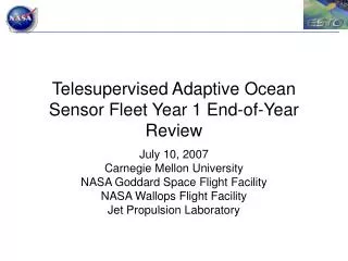
Telesupervised Adaptive Ocean Sensor Fleet Year 1 Interim Review Feb. 23, 2007 Carnegie Mellon University NASA Goddard Space Flight Facility NASA Wallops Flight Facility Jet Propulsion Laboratory
Outline • Project and system overview (slides 2-4) • Technical status (slides 5-21) • Schedule, milestones, and work planned (slides 22-25) • Critical issues (slide 26) • Financial status (slide 27) • Educational outreach (slide 28) • Acronyms/glossary (slide 29)
Telesupervised Adaptive Ocean Sensor Fleet (TAOSF) PI: John Dolan, CMU Objective • Improved in-situ study of Harmful Algal Blooms (HAB), coastal pollutants, oil spills, and hurricane factors • Expanded data-gathering effectiveness and science return of existing NOAA OASIS (Ocean Atmosphere Sensor Integration System) surface vehicles • Establishment of sensor web capability combining ocean-deployed and space sensors • Manageable demands on scientists for tasking, control, and monitoring Artist's conception of telesupervised sensor fleet investigating a Harmful Algal Bloom. Approach Key Milestones • Telesupervision of a networked fleet of NOAA surface autonomous vehicles (OASIS) • Adaptive repositioning of sensor assets based on environmental sensor inputs (e.g., concentration gradients) • Integration of complementary established and emergent technologies (System Supervision Architecture (SSA), Inference Grids, Adaptive Sensor Fleet (ASF), Instrument Remote Control (IRC), and OASIS) • Thorough, realistic, step-by-step testing in relevant environments • Interface Definition Document Feb 2007 • Test components on one platform in water May 2007 • Autonomous multi-platform mapping of dye Jul 2007 • Science requirements for Inference Grid Feb 2008 • Multi-platform concentration search simulation May 2008 • HAB search in estuary for high concentration Jul 2008 • Moving water test plan & identify location Feb 2009 • Simulate test using in-situ and MODIS data May 2009 • Use MODIS data to target and reassign fleet Jul 2009 Co-I’s/Partners • Gregg Podnar / CMU • Jeffrey Hosler, John Moisan, Tiffany Moisan / GSFC • Alberto Elfes / JPL TRLin = 4
TAOSF Program Synergy AIST Value Added Outputs Inputs Tools and Technology Users ESTO Office ESTO Office Telesupervised Adaptive Ocean Sensor Fleet Project OASIS Platforms Planetary Exploration HAB Detection 4 PhD, MS, and BS students Adaptive Sensor Fleet / Instrument Remote Control GSFC Multi-Robot Telesupervision Architecture Collaborative Partner
OASIS Mapping of Harmful Algal Blooms • System Components • System Supervision Arch. (SSA) • Adaptive Sensor Fleet (ASF) • Instrument Remote Control (IRC) • Inference Grids (IG) • Marine platforms (OASIS) High-level planning and monitoring High-bandwidth, single-platform telepresence Low-bandwidth, multi-platform telemetry
Technical Status • Near-complete TAOSF architecture design (slides 6-9) • Software architecture integration progress (SSA-ASF-IRC-OASIS) (slides 10-11) • Ongoing Harmful Algal Bloom (HAB) dataset acquisition and analysis (slide 12) • Initial design and testing of ground-truthing system (slides 13-20) • OASIS platform development and testing (slide 21)
TAOSF Architecture Design (1) Connectivity of high-level components OASIS ASV System (EST) OASIS ASV System (EST) OASIS ASV System (EST/WFF) Platform Communicator (GSFC) Adaptive Sensor Fleet (GSFC) System Supervision Architecture (CMU/JPL) Multi-Platform Simulation Environment (GSFC) CMU: Carnegie Mellon University GSFC: Goddard Space Flight Center WFF: Wallops Flight Facility EST: Emergent Space Technologies JPL: Jet Propulsion Laboratory MySQL HTTP Instrument Remote Control OASIS Driver API
TAOSF Architecture Design (2) Detailed view of platforms, simulator, and communicator EST: OASIS ASV System Fleet Environment Mission Operations Environment Platform Gateway OASIS Platform Platform Driver GSFC: Platform Communicator Engineering Interface Message Converter OASIS Platform Network Services Logging State Model GSFC: Multi-Platform Simulation Environment Message Receiver Simulation Manager Environmental Models Platform Behavior Models OASIS Driver API Instrument Remote Control
TAOSF Architecture Design (3) Fleet Manager Sends position commands to boats based on plans developed in the Science/Goal Analyzer. Communications Client Provides bidirectional communications with the real or simulated platforms. Science/Goal Analyzer Plans efficient multi-platform coverage of designated regions based on hexagonal tesselation of the environment. ASF Web GUI Allows web-based specification of user goals via ASF. Can be bypassed by the SSA (see next slide) to insert automatically generated goals or user-generated goals at the SSA level. GSFC: Adaptive Sensor Fleet System Fleet Manager Comm. Client Goals Database Science/Goal Analyzer States/Models Database ASF Web GUI
TAOSF Architecture Design (4) OCU Operator Control Unit provided by SPAWAR Systems Center San Diego with modifications by CMU Robot Controller Provides tasking and monitoring of individual robots and groups. Based on existing CMU Robot Supervision Architecture. Science Data Analyzer Combines data from the robots and other sources (satellite imagery, buoys, etc.) to predict HAB locations. Remote Data Interface / Display Allows remotely-located scientists to review data both in real-time and as recorded playback. CMU/JPL: System Supervision Architecture OCU Interface OCU ASF Client Robot Controller Science Data Analyzer External Science Data Data Storage Handler Data Storage Remote Data Interface Remote Data Display
Software Integration • Nov 2006: API for Adaptive Sensor Fleet (ASF)-OASIS communications developed • Dec 2006: Conducted dry test of ASF commands sent to and engineering telemetry received from OASIS • Feb 2006: Initial integration of System Supervision Architecture (SSA) with ASF and existing U.S. Navy OCU (MOCU1) preparatory to SSA-ASF-OASIS end-to-end software test 1MOCU ( Multi-Robot Operator Control Unit) is developed by SPAWAR Systems Center San Diego (SSC-SD)
MOCU sending waypoints to and receiving engineering telemetry from ASF OASIS platform following waypoint trajectory Engineering telemetry
HAB Dataset Acquisition/Analysis Chesapeake Bay • Based on ROMS model of the Chesapeake Bay, investigating correlation between surface temperature and salinity • Obtained chlorophyll A and sea surface temperature MODIS data for the Delmarva region • Obtained descriptions of five potential HAB regions of study in the Chesapeake and Coastal Bays from the Maryland Dept. of Natural Resources Temperature Salinity MODIS sea surface temperature
Ground-Truthing System • Purpose: confirm data from OASIS platforms • Platform positions and “bloom” concentration measures • Means: aerial sensor/communications package • Carried aloft by an aerostat tethered to a human-piloted research boat • Sensor package: GPS position, barometric altimeter, magnetic compass, video camera filtered to enhance rhodamine WT imaging • Use existing JPL software for mosaicing and object recognition
Ground-Truthing System To confirm data from OASIS platforms: • Aerial camera with sensors: latitude, longitude, altitude & heading • Image the bloom and the boats Will use existing JPL software to geolocate boats and bloom.
Ground-Truthing System Initial Test — 2006-Nov-14 at JPL Simple initial test conducted with recording GPS and Digital Camcorder lifted on a tethered weather balloon. 1) GPS data was used to recover an aerial image of the test site from Google Earth (GE). 2) Camcorder images were overlaid on GE image.
Ground-Truthing System Initial Test — 2006-Nov-14 at JPL • Mosaic of camcorder images (sharp) overlaid on Google Earth image (blurry) • Position reconstructed from recorded GPS track data • Heading recovered manually
Ground-Truthing System Second Test — 2007-Feb-16 at JPL • Avionics package: • GPS • Barometric altimeter • Magnetic compass • Serial data link • Wide-angle monochrome camera • Video transmitter • Fins on package to limit rotation 1) GPS data was used to recover an aerial image of the test site from Google Earth (GE). 2) Camcorder images were overlaid on GE image.
Ground-Truthing System Second Test — 2007-Feb-16 at JPL Two frames from camera over parking lot test site annotated with GPS position, altitude above ground, and heading showing uncertainty. These data recorded simultaneously from sensor package.
Ground-Truthing System Second Test — 2007-Feb-16 at JPL • Test Image 1 overlaid on Google Earth image of parking lot • Test Image center within 3m of Google Earth GPS mark • Heading uncertainty includes Google Earth’s North. This will be improved with a more stable aerostat.
Ground-Truthing System Second Test — 2007-Feb-16 at JPL • Test Image 2 overlaid on Google Earth image of parking lot • Test Image center within 2m of Google Earth GPS mark • Heading off by more than 30˚ from Google Earth’s North. This will be improved with a more stable aerostat.
OASIS Platform Development OASIS about to launch OASIS at sea • 15 Nov 06: First open-ocean deployment of OASIS-2 • OASIS-2 has barometer, fluorometer, and temperature, humidity, and salinity sensors • OASIS-2 currently conducting long-term (2-3 day) operations testing • OASIS-1 being upgraded to OASIS-2 level
Year 1 Schedule 3Q06 4Q06 1Q07 2Q07 3Q07 4Q07 Software integration Overall architecture design Interface Definition Document Subsystem integration Adaptive sampling HAB data acquisition Initial algorithm development Sensors Ground-truthing system development Science sensor placement System testing In-water subsystem test In-water 1-platform test In-water multi-platform test Validate autonomous dye detection Yr. 1 start date: Sept. 5, 2006 Yr. 1 end date: Sept. 4, 2007
Year 1 Milestones • Conduct initial ground-truthing tests (at JPL) Nov 2006 • Complete/test ASF-OASIS interface Dec 2006 • Conduct interim ground-truthing tests (at JPL) Feb 2007 • Complete Interface Definition Document Feb 2007 • Test fully integrated (SSA-ASF-OASIS) software Apr 2007 • Test components on one platform in water May 2007 • Autonomous single-platform mapping of dye Jun 2007 • Autonomous multi-platform mapping of dye Jul 2007
Key Project Milestones • Interface Definition Document Feb 2007 • Autonomous multi-platform mapping of dye Jul 2007 • Multi-platform HAB search in estuary Jul 2008 • Use MODIS data to target and reassign fleet Jul 2009
Work Planned • Finalize Year 1 TAOSF architecture design • Test end-to-end software integration first in simulation, then with one platform in the water: issue commands to and receive engineering and science telemetry from OASIS • Use ROMS data to investigate ability to infer detailed salinity and temperature characteristics from sparse samples • Stabilize, refine, and conduct additional testing of ground-truthing system • Follow up initial contacts at Feb 2007 San Diego meeting • Stephan Kolitz expressed interest in inserting the dynamic replanning component of the Earth Phenomena Observing System (EPOS) as a module in the TAOSF system • We may be able to use Internet tasking of the EO-1 satellite (POC Dan Mandl) • Confer with Robert Morris about inserting his planning work in TAOSF
Critical Issues • The availability of the third OASIS platform for the July 2007 multi-platform test is dependent on the platform development schedule and NOAA funding of this parallel project. • The ability of the ground-truthing system to accurately detect rhodamine WT dye needs to be validated. • We have had difficulty obtaining good HAB or HAB-related datasets that would allow algorithm development and off-line testing of adaptive sampling.
PROJECT FINANCIAL STATUSTelesupervised Adaptive Ocean Sensor Fleet Notes: 1. Wallops has not charged the award yet, but will do so later in the year in lump sum(s) reflecting the planned average $10K/month spending rate. 2. GSFC began charging to the award in December 2006. Their planned average spending is $8K/mo.
Educational Outreach • Ellie Lin • Ph.D. student, Robotics • Carnegie Mellon University • Steve Stancliff • Ph.D. student, Robotics • Carnegie Mellon University • Jeff Baker • B.S. student, Computer Science • Duquesne University • Sandra Mau • Master’s student, Robotics • Carnegie Mellon University
Acronyms/Glossary • API – Application Program Interface • ASF – Adaptive Sensor Fleet • CMU – Carnegie Mellon University • Delmarva – Delaware/Maryland/Virginia • EST – Emergent Space Technologies • GSFC – Goddard Space Flight Center • HAB – Harmful Algal Bloom • IG – Inference Grids • IRC – Instrument Remote Control • JPL – Jet Propulsion Laboratory • MOCU – Multi-Robot Operator Control Unit • MODIS – Moderate-Resolution Imaging Spectrometer • MySQL – My Structured Query Language, a popular database management system • NOAA – National Oceanic and Atmospheric Administration • OASIS – Ocean Atmosphere Sensor Integration System • Rhodamine WT – a non-toxic liquid red dye commonly used in water-tracing studies • ROMS – Regional Ocean Modeling System • SPAWAR – Space and Naval Warfare Systems • SSA – System Supervision Architecture • TAOSF – Telesupervised Adaptive Ocean Sensor Fleet • WFF – Wallops Flight Facility