Download
1 / 48
480 likes | 501 Vues
Learn about the Upper Susquehanna-Lackawanna Watershed Community Demonstration Project, which established the PA GIS Consortium and launched a GIS master plan for the watershed. Discover the accomplishments, community benefits, and ongoing projects of this multi-purpose GIS initiative.

E N D
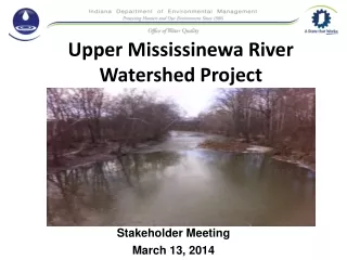
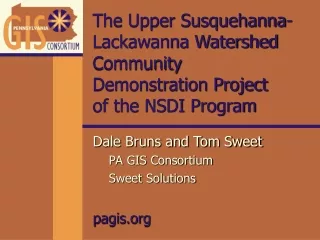
The Upper Susquehanna-Lackawanna WatershedCommunity Demonstration Project of the NSDI Program Dale Bruns and Tom Sweet PA GIS Consortium Sweet Solutions pagis.org
Overview of Presentation • Location and Background • Accomplishments 1 Established PA GIS Consortium 2 Launched GIS Master Plan for an American Heritage River Designated Watershed 3 Implemented design and deployment of a locally independent, regionally coordinated, multi-purpose GIS for Central and Northeastern Pennsylvania • Community Benefits • On-Going and Future Projects
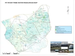
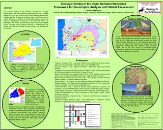
PA GIS Consortium Pennsylvania Chesapeake Bay Upper Susquehanna-Lackawanna Watershed’s Relationship to the Chesapeake Bay Ecosystem Project Location • Susquehanna River drains the largest U.S. river basin on the Atlantic coast • Susquehanna River contributes to over half of the freshwater inflow to the Chesapeake Bay • 120,000 acres of Abandoned Mine Lands within the Upper Susquehanna-Lackawanna River Basin • 3600 square miles - watershed delineation with Anthracite Fields
PA GIS Consortium Photo: Typical Pennsylvania Landscape
PA GIS Consortium Photo: Mining Operation
PA GIS Consortium Photo: Proximity of Mining to Human Landscape
PA GIS Consortium Brief History of Area 160 Years of Anthracite Mining • Surface Mining (base of mountain valleys) • Subsurface Mining (980 feet beneath the river) Five Billion Tons of Coal Removed (1807-1967) 1959 Knox Mine Disaster • Breach in the river (100,000 gallons per minute): “runaway” whirlpool • 200 rail cars, rocks, ties, poles, and hay dumped into hole
PA GIS Consortium Filmclip: Knox Mine Disaster
PA GIS Consortium Persistent Water Quality Problems Severely degraded stream with urban debris and mining sediments Mapping mine outfall locations with GPS technologies
PA GIS Consortium Abandoned Mine Lands Strip Mine Culm Bank Reclaimed Land
What was accomplishedin Demonstration Project PART 1 Established PA GIS Consortium
What is the PA GIS Consortium? • Incorporated as a Pennsylvania-based 501(C)(3) • Administered through it’s startup phase by an independent Board of Directors • Looking for local partners, members and sponsors
What is the PA GIS Consortium’s mission? To support the design and deployment of locally independent, regionally coordinated, multi-purpose Geographic Information Systems for Central and Northeastern Pennsylvania
What that means in order of priority • Support the design and deployment of GIS that meet local needs and preserve local independence • Do so in a regionally coordinated manner that increases efficiency and effectiveness • Increase savings and leveraging power by getting multiple uses of the end product(s)
Education Sector Partners • Wilkes University • Center for Geographic Information Sciences • King’s College • The Marketing and Planning (MAP) Center in the William G. McGowan School of Business
Private Sector Partners • ESRI • Marconi Imaging Systems • Aerial Data Reduction (ADR) • CETROM • ERIM
Public Sector Partners (Federal) • Vice President Gore’s National Partnership for Reinventing Government • Federal Geographic Data Committee of the U.S. Department of the Interior • U.S. Army Corps of Engineers • U.S. Environmental Protection Agency • U.S. Department of Agriculture
Public Sector Partners (State) • Pennsylvania Mapping and Geographic Information Consortium • Department of Environmental Protection
Local Partners • Luzerne County • The Town of Bloomsburg • Columbia County • Wilkes-Barre Chamber of Business and Industry • Wyoming Valley Sanitary Authority • Earth Conservancy
Created Regional Visualization Web Sitesmapcenter.org PA GIS Consortium
Regional Visualization Centerpaheritageriver.org/pagis.org PA GIS Consortium pagis.org paheritageriver.org
Regional Visualization Centermapcenter.org PA GIS Consortium mapcenter.org
Regional Visualization Centerpaheritageriver.org PA GIS Consortium paheritageriver.org
Regional Visualization Centerpagis.org 1 PA GIS Consortium pagis.org
Regional Visualization Centerpagis.org 2 PA GIS Consortium
What was accomplishedin Demonstration Project PART 2 Launched GIS Master Plan for an American Heritage River Designated Watershed
PA GIS Consortium GeoSpatial Technologies for Coal Field Reclamation GIS for Watershed Analysis • Characterize and Assess • Ecological conditions (2000 square mile area) • Anthracite Fields • strip mines • mine pool • culm banks • acid mine outfalls • Geospatial Technologies • GIS and GPS • Remote Sensing and Digital Photogrammetry • Watershed Analysis • provide first step to testing landscape-watershed indicators of pollution • regional scale (federal) data Site of Knox Mine Disaster Wilkes-Barre Nanticoke
PA GIS Consortium Ecosystem Hierarchy from Landscape to Watershed to Stream Reach
Environmental Applications of Federal Data (small-scale) • DOI, Office of Surface Mining • Abandoned Mine Lands (120,000 acres) • Acid Mine Drainage (51 tons of iron/day on river corridor at low flow) • DOI, U.S. Geological Survey • Water Quality, Hydrography, Watersheds • Digital raster graphs, DOQQ • EPA EnviroMapper: OpenLinks on Web • EPA • Acid Mine Streams • Mid-Resolution Land Characterization (MRLC) • EPA BASINS: STORET Data and Models on GIS
PA GIS Consortium Landscape-Watershed Analysis land cover macroinvertebrate communities biodiversity index statistic correlation (land cover vs. water chemistry, macroinvertebrates and biodiversity)
PA GIS Consortium Solomon Creek Watershed Green represents taxa richness variations USGS mining impacted areas shown in brown Rich Taxa Poor Taxa Solomon Creek Watershed Taxa Richness
All Indices Solomon Creek Watershed PA GIS Consortium
PA GIS Consortium USGS Water Quality Survey:The 100 Largest Mine Discharge Sites in the Anthracite Region
EPA EMPACT presentation map PA GIS Consortium
What was accomplishedin Demonstration Project PART 3 Implemented locally independent, regionally coordinated, multi-purpose GIS Deployment Strategy for Central and Northeastern Pennsylvania
PA GIS Consortium Flight 2000Initiative Original Target Area Final Target Area
Local and Regional GIS: Implementation • Data acquisition and maintenance • Base mapping (parcel management) • Hardware and software acquisition • Education and training • Technology transfer
Data Distribution Strategy for Regional GIS • Data Exchange Procedures • facilitate distributed data storage • coordinate maintenance and access • Design of a GIS Architecture Plan • ArcIMS • ESRI Partner Support • (Chris Cappelli-Philadelphia office)
PA GIS Consortium Data Distribution Strategy Users Regional Model: Distributed GIS (locally maintained and regionally coordinated) ENHANCED BROWSER BASIC BROWSER PUBLIC OTHER LOCAL STATE FEDERAL vectors, features images Internet PA GIS CONSORTIUM regional coordination WEB Server WEB Server ArcIMS ArcIMS SDE SDE SDE LOCAL County Municipality Agency University Other DATA DATA DATA L2 L3 L1 Large Scale/Local Data
Start-up Applications of ArcIMS • Parcel Maps and Ortho-photos • Municipal and County Partners • Local Large Scale Data • Local Data linked to EPA EnviroMapper • “data fusion” local to federal • Real-time Water Quality Instrumentation • One of five sites in Chesapeake Bay Watershed • EPA Community EMPACT “tech-transfer” • Goal: Kiosk link to Baltimore National Aquarium
Mistake avoidance Improve data management Reduced startup times and costs Cost sharing activities Economies of scale Past deployments of this model have produced savings of 10 to 75 cents on the dollar Community Benefits of a locally independent, regionally coordinated GIS
Community mobilization for environmental reclamation Helping to diminish the “Digital Divide” Reduced startup times and costs Cost sharing and reduction activities Facilitate land use planning for “Smart Growth” Launching GIS Watershed Plan Deployment of locally independent GIS with investment in base map ortho-photos NSDI Project Benefits
On-Going and Future Consortium Projects Environmental Master Plan of the Upper Susquehanna-Lackawanna Watershed Support to the American Heritage River Initiative EPA Environmental Initiative (Project EMPACT - Chesapeake Bay Watershed) USDA Rural GIS Flight 2000: Data Processing and Distribution
Congressman Paul Kanjorski and Staff Department of Interior NSDI Program FGDC U. S. EPA (Dave Catlin, NSDI GIS Champion) USDA (sponsor of AHR Navigator, Alex Rogers) USGS U. S. Army Corps of Engineers King’s College Wilkes University ESRI (Chris Cappelli) Sweet Solutions Marconi Systems/ADR Acknowledgements
PA GIS Consortium Contact information:pagis.org