Download
1 / 6
60 likes | 204 Vues
Presentation for ECE539 Jason Mielens ( mielens@wisc.edu ) 12/12/08. Self-Organizing Maps for Land Cover Classification. Land Cover Overview. Map of surface type Open Water Grassland Bare / Rocky Forest Urban / Developed LandSat Satellite Captures reflectance in 7 wavelengths

E N D
Presentation for ECE539 Jason Mielens (mielens@wisc.edu) 12/12/08 Self-Organizing Maps for Land Cover Classification
Land Cover Overview • Map of surface type • Open Water • Grassland • Bare / Rocky • Forest • Urban / Developed • LandSat Satellite • Captures reflectance in 7 wavelengths • 0.45 – 2.35 µm • Main data source
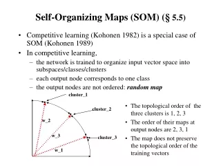
Self-Organizing Map • The map is a standard 2D SOM, in a hexagonal configuration, 5x5
Inputs • Landsat Bands • Cartographic info • Elevation • Slope • Aspect (direction slope faces) • Distance from water (river / lake / ocean) • Distance from road
Progress / Results • Reflectance only • Average around 60% • Ancillary data • Average around 70% • Considering additional datasets which could be useful • Currently working on preprocessing the Landsat data more to improve accuracy.