Download
1 / 21
210 likes | 314 Vues
This paper discusses the importance of cyberinfrastructure (CI) in the geosciences, emphasizing its role in democratizing access to scientific data and tools. By utilizing state-of-the-art IT solutions, CI facilitates day-to-day scientific activities beyond high-end computations. The document presents principles for effective CI development, such as a two-tier approach, best practices in data sharing, and creating integrated databases. It argues for the necessity of open-source technology and collaboration among researchers, industry, and government to enhance scientific progress and accessibility.

E N D
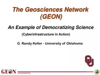
The Geosciences Network (GEON) (Cyberinfrastructure in Action) An Example of Democratizing Science G. Randy Keller - University of Oklahoma
Some CI Principles • Use state-of-the-art IT to support the “day-to-day” conduct of science (e-science), not just “heroic” computations • Develop advanced IT where needed • An environment based on Web/Grid services and other distributed technologies • The “two-tier” approach • Use best practices, including commercial tools, • Develop advanced, open source technology while conducting CS research • An equal partnership • IT works in close conjunction with science, to create CI (i.e. the best practices, data sharing frameworks, and useful and usable capabilities and tools) • Shared effort • Create shared “science infrastructure” • Integrated online databases with advanced search engines • Online models, robust tools and applications, etc. • Leverage from other intersecting projects • Much commonality in technologies needed exists, regardless of the science disciplines • Constantly work towards eliminating (at least, minimizing) the “NIH” syndrome (Not Invented Here) • And, importantly, try not to reinvent what industry already knows how to do… • Technologies to bring remote resources together
Why Geoinformatics? It is too hard to find and work with data that already exist, and too much data is in effect lost. It is too hard to acquire or access software tools and make them work. We have too little access to modern IT tools that would accelerate scientific progress. The result is too little time for science! Also, a wide range of students, scientists and engineers, industry, policy makers, and the public should have access to data and usable software tools. To begin to remedy this situation, a number of geoscience groups are being supported by the National Science Foundation to develop the cyberinfrastructure neededto move us forward. www.geongrid.org
A Scientific Effort Vector What Can We Expect from From Cyberinfrastructure? Background Research Data Collection and Compilation; Learning and Developing Software Science Highly Integrated Science Back- ground Research Science - Analysis, Modeling, Interpretation, Discovery www.geongrid.org
SomeThoughts About Data (sets, bases, systems) • The Geosciences are a discipline that is strongly data driven, and large data sets are often developed by researchers and government agencies and disseminated widely. • Geoscientists have a tradition of sharing of data, but being willing to share data if asked or even maintaining a website accomplishes little. Also we have few mechanisms to share the work that has been done when a third party cleans up, reorganizes or embellishes an existing database. • We waste a large amount of human capital in duplicative efforts and fall further behind by having no mechanism for existing databases to grow and evolve via community input. • The goal is for data to evolve into information and then into knowledge as quickly and effectively as possible. www.geongrid.org
Data layers DEM (USGS, SRTM) Geology (mostly 1:500,000) Landsat 7 / ASTER Petrology/Geochron. (e.g. NAVDAT) Drilling data (State surveys, USGS) Magnetics Gravity ………. To get 3-D, start with tomography, add gravity, geologic interfaces, seismic interfaces, …. Provide input to geodynamic models www.geongrid.org
Earthquakes Geology We start at the surface and work down (3-D) and back in time (4-D) Tectonics Faults Aquifers Moho depth Gravity Mines Focal Mechanisms Sediment thickness Topography Magnetics CYBERINFRASTRUCTURE FOR THE GEOSCIENCES Complied by Dogan Seber and A.K.Sinha
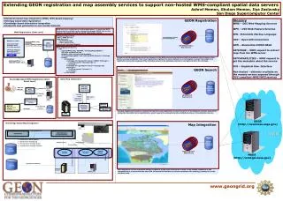
PI Institutions Arizona State University Bryn Mawr College Penn State University Rice University San Diego State University San Diego Supercomputer Center/UCSD University of Arizona University of Idaho University of Missouri, Columbia University of Oklahoma University of Texas at El Paso University of Utah Virginia Tech UNAVCO Digital Library for Earth System Education (DLESE) Partners ESRI California Institute for Telecommunications and Information Technology, Cal-(IT)2 Chronos CUAHSI-HIS Geological Survey of Canada Georeference Online HP IBM Kansas Geological Survey Lawrence Livermore National Laboratory NASA Goddard, Earth System Division Southern California Earthquake Consortium (SCEC) U.S. Geological Survey (USGS) Purdue University Affiliated Projects EarthScope, IRIS The GEON Project • NSF-funded IT Research Project, • 2002-2007, $11.6M • 15 participating institutions across US • Over 20 other partner institutions, • including universities, industry, • government agencies/labs (USGS, NASA, Livermore)
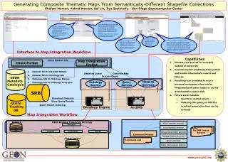
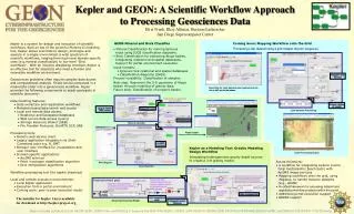
GEON Project Overview • Close collaboration between geoscientists and IT to interlink databases and Grid-enable applications • “Deep” data modeling of 4D data • Situating 4D data in context—spatial, temporal, topic, process • Semantic integration of Geosciences data • Logic-based formalisms to represent knowledge and map between ontologies • Grid computing • Deploy a prototype GEONgrid: heterogeneous networks, compute nodes, storage capabilities. Enable sharing of data, tools, expertise. Specify and execute workflows • Interaction environments • Information visualization. Visualization of concept maps • Remote data visualization via high-speed networks • Augmented reality in the field
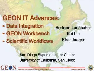
Technical Areas • GEONgrid • Deployment of a distributed data sharing and computing infrastructure, consisting of GEON “nodes”, which provide a interoperable software environment • Data integration • GIS Map Integration • Knowledge-based integration of WMS (Web Mapping Services) • Database Schema integration • Seamless access to different types of data systems, e.g OpenDAP • Knowledge Representation • Geo-Ontology development • “Wrapping” science tools and applications • As Web services… • Invoked using scientific workflow software, e.g. Kepler, …and • Executed on Grid computing platforms, via portals • Visualization • 2D, 2.5D, 3D, 4D • Common data models, frameworks (e.g. between geophysics and geology)
Kenya vs Rio Grande rifts www.geongrid.org
Albuquerque basin 3-D view of base of rift fill (maximum depth 5 km) V. J. S. Grauch - USGS
International GEON Activities • PRAGMA: Pacific Rim Assembly for Grid Middleware Applications • GEON is a project supported by PRAGMA • GEON co-chairs the PRAGMA Geosciences Working Group • Japan • Collaboration with AIST’s GEO Grid project • Sharing of technology and data. Use of GEON LiDAR data to validate GEO Grid ASTER-based DEMs • China • GEON Workshop, October 2006, Beijing. Co-sponsored by Chinese Academy of Sciences. • Russia • GEON Workshop, July 2007, Moscow. Co-sponsored by Russian Academy of Sciences • India • Joint project with University of Hyderabad, funded by the Indo-US Science and Technology Forum ($100K/2 years) • GEON workshops in October 2005 and August 2007 • iGEON-India network in India • Australia • Discussions with AuScope staff • New Zealand • Planning a GEON Workshop in November 2007 at University of Auckland.
Resources • GEON (http://geongrid.org) • Summer workshops for scientists and educators • Data and tools for geosciences • Cyber-ShARE (http://trust.utep.edu/cybershare) • Visiting Researcher Program • Workshops • Research opportunities for graduates and UG • High Performance Wireless Research and Education Network (HPWREN) (http://hpwren.ucsd.edu/) • MSI-CI Empowerment Coalition (MSI-CIEC)