Revolutionizing Wind Forecasting: Impact of Ocean Vector Winds on Hurricane Force Conditions
Explore the significant impact of QuikSCAT wide swath 2 passes per day consistency on forecasting hurricane force conditions, improved algorithm accuracy, and cultural change in operational warning processes. Discover the evolution of wind forecasting and its critical role in predicting and responding to intense cyclones.

Revolutionizing Wind Forecasting: Impact of Ocean Vector Winds on Hurricane Force Conditions
E N D
Presentation Transcript
Ocean Vector Wind Experience Joe Sienkiewicz NOAA Ocean Prediction Center
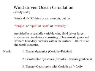
NOAA Ocean Prediction Center – impact on operations QuikSCAT wide swath 2 passes per day consistency wind range Cultural change revolutionized warning, analysis and forecast processes focus on Hurricane Force conditions Success – timely availability in forecaster workstations
kts Hurricane Force Extratropical Cyclone Intense, non-tropical cyclones with hurricane force winds Feb 09, 2007, North Atlantic
Improved wind algorithm, rain impact flag available Oct 06 QuikSCAT winds Operational in N-AWIPS Workstations Oct 01 12.5 km QuikSCAT Available May 04 Hurricane Force Wind Warning Initiated Dec 2000 QuikSCAT Launch Jun 99 Atlantic -194 Pacific - 177 371 HF Cyclones Hurricane Force Extratropical Cyclones Observed
34-kt wind radii from QuikSCAT Accurate 34-kt wind radii critical for timing and placement of coastal watches and warnings QuikSCAT and Tropical Cyclones at NHC • Estimating intensity, especially for tropical depressions and tropical storms, but cannot be used for major hurricanes • Detection/tracking of TC centers for analysis and model initialization • Improved gale and storm force wind radii analysis in TCs affects watch/warning areas
Gap Winds – Gulf of Tehuantepec 12.5-km retrievals available • Eight-year QuikSCAT-based climatology finds average of 12.4 gale-force events and 5.5 storm-force events per season • 10-m wind guidance from operational NWP guidance currently available to TAFB forecasters has little skill in predicting storm-force Tehuantepec events • Composite results suggest there may be identifiable synoptic-scale signals to help forecasters differentiate between storm-force and gale-force Tehuantepec events
kts Diagnostic of NWP initial conditions GFS – 3 hour forecast of wind speed 12.5 km QuikSCAT Maximum Wind speed 20 knots Maximum Wind speed 40 knots A GALE warning was issued.
Magnitude of SST gradient GOES SST composite Winds near SST gradients
Winds near SST gradients GFS wind speed bias for marginally stable PBL
OSVW Measurements • Benefit - mainly to offices with large areas of ocean responsibility • Limitations to date – coastal waters, rain, resolution, and retrievals in high winds
Existing, Planned & Proposed OVW Missions 97 98 99 00 01 02 03 04 05 06 07 08 09 10 11 12 13 14 15 1000 km MIS C-2 WINDSAT 500 km – failure ofon-board recording 2 x 550 km w/ 720-km nadir gap ERS-2 ASCAT/METOP – 3-satellite series AMI/ERS-2 Timely data access / quality? HY-2 – 3-satellite series Timely data access /quality? SeaWINDS/ADEOS-II OceanSat-2 scatterometer 1800 km Seawinds/QuikSCAT Q’SCAT Follow-on In orbit Approved Planned/Pending Approval