GPS 4 GIS
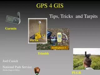
GPS 4 GIS. Tips, Tricks and Tarpits. Garmin. Pro XR. GeoExplorer 3. Trimble. Joel Cusick National Park Service Alaska Support Office. PLGR. Outline. Dictionary of Terms How GPS Collects Data Overview of Main GPS Receiver Types The Right Tool for the Job Tarpits. Assumptions.

GPS 4 GIS
E N D
Presentation Transcript
GPS 4 GIS Tips, Tricks and Tarpits Garmin Pro XR GeoExplorer 3 Trimble Joel Cusick National Park ServiceAlaska Support Office PLGR
Outline • Dictionary of Terms • How GPS Collects Data • Overview of Main GPS Receiver Types • The Right Tool for the Job • Tarpits
Assumptions • You collect or receive GPS data collected in Alaska • You try to minimize positional errors along the way • Ultimate goal is a GIS dataset
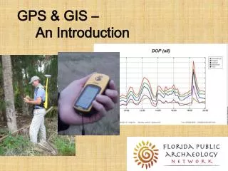
Dictionary of Terms • Global Positioning Systems (GPS) • Differential GPS • Real-Time Differential GPS • Post-Process Differential GPS • How GPS collects Features in the Field
GPS Space Segment • Tracking a GPS Satellite Vehicle (SV) • 28 Satellites • Distance = 12,0000 miles • Speed = 6000 mph http://liftoff.msfc.nasa.gov/realtime/jtrack/3d/JTrack3d.html
Garmin Pro XR GeoExplorer 3 Trimble GPS Ground Segment • Mapping Grade Receivers • Recreational Grade Receivers
Garmin Dictionary of Terms • GPS • Not for navigation anymore • Since Selective Availability SA was turned off….. • $300 unit can map at 1:24,000 scale (+/- 12m) • in the open • but not under canopy http://www.fs.fed.us/database/gps/
Dictionary of Terms • Differential Global Positioning System (DGPS) • Any system that can remove atmospheric errors in a GPS solution (greatest error after SA) • Realtime • or back in the office - Post-Process
Dictionary of Terms • Real Time Differential GPS • CORS BASE Stations • In Alaska - depends on where you are at and how lucky you are • Dependent on the CORS Network - Gulf of Alaska: • Hit / Miss • Not dependable
Dictionary of Terms • Real Time Differential GPS • WAAS • Wide Area Augmentation System • Designed for high flying aircraft • 2 Geostationary satellites (parked over equator) • 3 meter solution (if the GPS is enabled) • Hit / Miss in AK • Poor under any canopy Tip: Other Satellite DGPS systems like StarLink do not cover AK
Dictionary of Terms • Post-Process Differential GPS • Dependent on the CORS Statewide Network and community base stations • Increasing coverage • Prudhoe Bay on line • Kotzebue soon? • Baselines have significantly decreased Tip: For every 100km between base and rover, add additional 0.1m of error
Dictionary of Terms • GPS View of the World How a digitizing tablet is used today
Dictionary of Terms • Digitizing Terms Traditional Way GPS Way Tablet Earth Puck GPS Antenna Nodes / Vertices Positions GRAIN or WEED {*| DEFAULT | distance} Logging Rate
Dictionary of Terms • A GPS View of GIS Features • Point features are one or more positions averaged into a point • Mapping Grade Receivers : Called “Points” • Recreational Grade Receivers : Called “Waypoints” • String of positions converted into a line / area • Mapping Grade Receivers : Collected directly in the field as a line / area feature • Recreational Grade Receivers : Collected as a “TrackLog” then converted back in the office
Waypoint1 N 61 13 9.0 W 149 53 28.4 Line and Point Features
Distance is the logging rate A GPS Line or Tracklog = Vertices Start
Collecting Points or Waypoints along the Way Multiple positions averaged into a point
What a GPS Mapping Receiver Should Do • Hardware • Software
What a GPS Mapping Receiver Should Do • Hardware • Accuracy (How close to Truth) • Meet National Mapping Accuracy Standards: • 1:63,360 (32meters) • 1:24,000 (12 meters) • 1:5,000 (4 meters) • Precise (How reliable) • Rugged • Able to Average Positions into a Point • External Antenna Options • Good on Batteries No Problem! Most Likely With Effort Tip: A Pause button is crucial to creating clean line/poly data in the field
What a GPS Mapping Receiver Should Do • Software • Export in GIS Friendly Formats (shapes, coverages, DXF) • Capable of Controlling Attributes in the Field • Data Dictionary (Name, Trail Width, Comments) • Capable of Datum Transform - To NADCON 27 • Mission Planning • Sky Plots • Planning the day • Able to Differentially Correct (Realtime or Post-process)
Overview of Main Types • Recreational Grade GPS - Garmin • Mapping Grade GPS - Trimble • Y-Code Receivers - Rockwell PLGR+96 • GPS/GIS Field Mapping Tools Nerd Factor
Recreational Grade GPS - Garmin • Features Include: • Accuracy: • Autonomous < 15meters 68% • DGPS ready 1-5 meters 68% • User Friendly • Many models • Garmin GPSIII+, GPSMap76, eTrex • Moving Base Maps (1:100,000 scale) Garmin RealTime Kit
Mapping Grade GPS - Trimble • Features Include: • Accuracy: • Autonomous < 15meters 68% • Post-Process DGPS • 3-5 meters 95% (Geo3) • 1 meter 95% (ProXR) • Pathfinder Office Software • Data Dictionary, Mission Planning Trimble
Y-Code Receivers - PLGR+96 • Features Include: • Accuracy: • Autonomous < 15meters 68% • Club Fed Only • Good under Canopy PLGR
GIS/GPS Field Mapping Tools • GPS unit + Handheld PC(CE) + ArcPad: • Realtime display of vector /raster data • Hook to any GPS • Unlimited Storage (dependent on storage capacity of device) • Instant shapefile creation • Application builder($1500) Garmin and IPAQ running ArcPad
GPS for GIS - Pros and Cons • Garmin III+ • Pros • Cheap and consistent 15 meters positions - okay under canopy • Good “Point tool” • Fun / easy to use and easy to navigate with • Integration into ArcView - relatively straightforward • Battery usage is great • Cons • Cheap • No GPS Filters (2D Fixes Given, SNR, PDOP, MASK Angle set to 5) • Position accuracy not recorded • Not designed for GIS Mapping - relies on 3rd party software • No Data Dictionary capability Large Errors!
GPS for GIS - Pros and Cons • Trimble GeoExplorer 3 • Pros • 2-5 meter mapping tool • Point/Line/Poly Tool • Rugged • Collect data for 16 hours • Exports in coverage or shapefile • Excellent software (Pathfinder Office) • Cons • Requires additional training • $4000 • Under Canopy issues - Velocity filtering / Use Antenna • Need to post-process after the field (internet connection)
GPS for GIS - Pros and Cons • Trimble Pro XR • Pros • Top-of-the-line GIS Mapping Tool • Submeter to 2 meter Tool • Real-time DGPS • Point/Line/Poly • Excellent under Canopy • Rugged • Exports in coverage or shapefile • Excellent software (Pathfinder Office) • Cons • Requires additional training • $8,000 - $10,000 • Big/Bulky • Need to post-process after the field (internet connection)
GPS for GIS - Pros and Cons • PLGR • Pros • Good “Point tool” • Records error and Datum • Integration into ArcView - relatively straightforward • Cons • Older technology - Phasing Out • Heavy • Does not store an AVERAGED solution • Terrible on batteries • Club Fed only • No Data Dictionary capability
GIS/GPS Field Mapping ToolsPros and Cons • IPAQ / ArcPad • Pros • Now can select GPS Filters (SNR, PDOP) • Creation of shapefiles • Pen-based digitizing from the air • Measure distances in field • Cons • Not a tight package (GPS, cables, ipaq, cradle, software, data) • Small screen view • Purchase of ruggedized collectors($900 - $3000) • GIS skills support is high (design forms, maintain/move data) • Battery usage poor
Right Tool for the Right Job • Sorry… It’s a Multi - Tool Environment • Garmin • Trimble • …..PLGR • Need to learn enough about each system to know when to use the tool
Right Tool for the Right Job • Mapping Scenarios: • Garmin / PLGR • Mapping sheep from the air? • Record cabin (points) location for fire • Photo control for georeferencing an AHAP (1:60,000) photo • Mapping study sites; Inventory and Monitoring • Garmin\PLGR\Trimble • Mapping a trail from a fast moving vehicle or by air (moving)
Right Tool for the Right Job • Mapping Scenarios cont: • IPAQ/ArcPad • Mapping fires from the air - need to know position now • ARC IMS connectivity to mothership??? • Trimble • Mapping a Road while collecting point features along the way • Mapping a trash can lid • Mapping complex attributes? • Photo control for larger scale maps (1:12,000) • Updating of existing GIS layers • PLGR • In Dense Canopy (but prefer XR)
Right Tool for the Right Job • Putting it another Way: • If accuracy is the key... • Map a SUV - Garmin or PLGR • Map a small Subaru - Garmin (Average) or Trimble • Map a bunch of scooters - Trimble and post process • Map the four corners of an archeology dig (10 meters across) • Pull out the Survey equipment • If mapping features is the key... • Map a trail network - limited funds, inexperienced personnel - Garmins • Map a campground - tentpads, sign posts- Trimble
What is Best? • Ask Yourself • 1) What are your accuracy needs? • A) resolution of the other data types • B) anticipated data for the future • 2) Project Needs • A) What are the crews GIS skills • B) Is it just you dealing with the data • 3) What part of Alaska are you working in? • 4) How much money do you have?
TARPITS • Cleaning the data • Datums • When to Hang it up
QC / Clean Tarpit • Coverages • Set Precision to Double Double • Check out the data tolerances first -measure distances between vertices • Watch for places where a GPS was left on and dropped a bunch of vertices
GPS Datum Tarpit • What’s the big deal • Differences: • WGS84(NAD83) to NADCON Alaska 27 = 100-150meters • 3parameter NAD27 to NADCON Alaska 27 = 1.5 - 8 meters • #1 - KNOW the Datum • Accept that 1.5 - 7 meters might not be a big deal • Depending on the GPS, method of acquisition, scale of base data etc. • In your mind, switch WGS84 with NAD83
GPS Datum Tarpit • How to deal with it • Ask? Demand the Datum be written down • Know how the Data arrives to the PC • Garmin - Garmin Protocol - WGS84(NAD83) • Garmin - via NMEA - up to the Display • If a Trimble • Handle datum in Software - FOR NAD27 EXPORTS ! USE NADCON27 ALASKA Airplane GPS is always WGS84
Datum Solutions • Use prj files to eliminate the define projection step • Keep a set of NAD83 and NAD27 prj files around • Copy the prj alongside the *.dbf, *.shx, *.shp GEOGCS["GCS_North_American_1983",DATUM["D_North_American_1983",SPHEROID["GRS_1980",6378137,298.257222101]],PRIMEM["Greenwich” ,0],UNIT["Degree",0.0174532925199433]]
GPS Data Tarpits • When to “Hang it Up” • Effective GPS for GIS purposes requires • In Super thick canopy or canyons????? • Attentive field personnel (“A Field Nerd”) • Mapping may be more efficient by.. • remote sensing • heads-up digitizing
Summary • GPS not for navigation alone • Rapidly evolving technology - Migration to Windows CE and mult-tasking environments • GPS Toolbox may require several tools to get the job done • Instead of waiting for an updated Map product do it yourself and enjoy the outdoors