Download
1 / 77
780 likes | 912 Vues
Weather Radar systems for mitigation of volcanic cloud hazards to aircraft. William I Rose Michigan Technological Univ. Based on paper by C. Lacasse, S. Karlsdóttir, G Larsen, H Suusalu, W I Rose and G G J Ernst, 2003 Weather radar observations of the Hekla 2000 eruption cloud, Iceland,

E N D
Weather Radar systems for mitigation of volcanic cloud hazards to aircraft William I Rose Michigan Technological Univ Based on paper by C. Lacasse, S. Karlsdóttir, G Larsen, H Suusalu, W I Rose and G G J Ernst, 2003 Weather radar observations of the Hekla 2000 eruption cloud, Iceland, Bulletin of Volcanology 66:457-473 Keflavik, Iceland Fall 2009 Ashfall Graduate Class lecture
Meteorological Radar Systems are designed to detect “large” (raindrop-sized) particles such as those found in thunderstorms. They are pulsed, active remote sensing systems which send and receive electromagnetic radiation with wavelengths of 3-10 cm. The strength of radar return from a cloud is measured in dBz, a unit which is based on relative numbers of mm sized raindrops in a specific volume of cloud. Large particles produce MUCH stronger returns than small ones--the relationship scales to the SIXTH POWER of the radius. The detection is excellent for particles that are cm sized, and very poor for particles smaller than 1 mm….
Explosive Eruption +15 sec. +30 sec. +40 sec. +60 sec. +5 min.
Volcanic Clouds can only be distinguished by radar if large particles are present. But such particles must fall quickly… So radar mapping becomes problematic after the volcanic cloud is more than 30 min old and the large particles have fallen out. Practical Strategy: Use the radar during eruption and immediately after it. Obtain height information and determine the direction and speed of movement. Then, if you wish to track it after that--you need another tool (eg infrared satellite data).
Sept 17-20, 1992 Schneider et al, 1995, USGS Bull 2139: 27-36
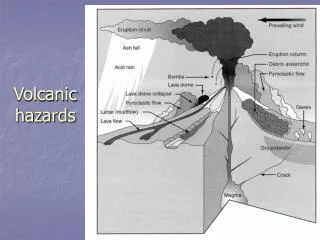
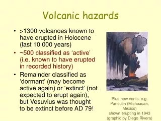
Hekla Elongate Shield Volcano Regular series of eruptions (1845, 1947, 1970, 1980, 1991) Began eruption on Feb 26, 2000 at 1800 UT Silicic explosive onset to eruptions Brief explosions followed by fissure fed lava flows 2000 Eruption of Hekla Explosive onset Older Hekla silicic fall deposits Fissure activity and lava flows--main phase
26 Feb 2000 1835 UT Ground view of Hekla eruption column, as seen from Vik, Iceland, ~67 km SSE of the volcano (J. Erlendsson)
DMSP VIS 2/26/00 1815 UT shadow Remote sensing of the brief explosive phase of the eruption shows development of cold cloud with shadows, winds and temperatures reflecting the tropopause. Rose et al, 2003, AGU Geophys Monograph 139
Range-height diagram for Keflavik radar, applicable during the Hekla eruption. Shaded region shows detection limits.
The maximum height limit set on the Keflavik radar was determined based on meteorological, not volcanological criteria. Although there may be advantages during routine operations when there is no eruption, this decision unfortunately limited the ability of the radar to measure the maximum height of the eruption cloud. The farther the volcano is from the radar, the more the minimum height is affected---this is due to curvature of the earth. Thus the early onset of explosive eruptions will be missed for more distant volcanoes. The overall maximum range of the radar is listed at 480 km, but practically this is an overestimate, because of curvature.
Hekla 100 km Vertical Maximum Intensity VMI “normal” before erupttion
Keflavik Radar • 26 Feb 2000 • 1820 UT • VMI normal • Lacasse et al, 2004, Bull Volcanology Hekla
Keflavik Radar • 26 Feb 2000 • 1830 UT • VMI normal • Lacasse et al, 2004, Bull Volcanology
Keflavik Radar • 26 Feb 2000 • 1840 UT • VMI normal • Lacasse et al, 2004, Bull Volcanology
Keflavik Radar • 26 Feb 2000 • 1850 UT • VMI normal • Lacasse et al, 2004, Bull Volcanology
Keflavik Radar • 26 Feb 2000 • 1900 UT • VMI normal • Lacasse et al, 2004, Bull Volcanology
Keflavik Radar • 26 Feb 2000 • 1910 UT • VMI normal • Lacasse et al, 2004, Bull Volcanology
Keflavik Radar • 26 Feb 2000 • 1920 UT • VMI normal • Lacasse et al, 2004, Bull Volcanology
Keflavik Radar • 26 Feb 2000 • 1930 UT • VMI normal • Lacasse et al, 2004, Bull Volcanology
Keflavik Radar • 26 Feb 2000 • 1940 UT • VMI normal • Lacasse et al, 2004, Bull Volcanology
Keflavik Radar • 26 Feb 2000 • 2015 UT • VMI normal • Lacasse et al, 2004, Bull Volcanology
Keflavik Radar • 26 Feb 2000 • 2045 UT • VMI normal • Lacasse et al, 2004, Bull Volcanology
Keflavik Radar • 26 Feb 2000 • 2130 UT • VMI normal • Lacasse et al, 2004, Bull Volcanology
Keflavik Radar • 26 Feb 2000 • 2200 UT • VMI normal • Lacasse et al, 2004, Bull Volcanology
Keflavik Radar • 26 Feb 2000 • 2230 UT • VMI normal • Lacasse et al, 2004, Bull Volcanology
Keflavik Radar • 26 Feb 2000 • 2300 UT • VMI normal • Lacasse et al, 2004, Bull Volcanology
Keflavik Radar • 27 Feb 2000 • 0000 UT • VMI normal • Lacasse et al, 2004, Bull Volcanology
Keflavik Radar • 27 Feb 2000 • 0100 UT • VMI normal • Lacasse et al, 2004, Bull Volcanology
Keflavik Radar • 27 Feb 2000 • 0230 UT • VMI normal • Lacasse et al, 2004, Bull Volcanology
Keflavik Radar • 27 Feb 2000 • 0400 UT • VMI normal • Lacasse et al, 2004, Bull Volcanology
Keflavik Radar • 27 Feb 2000 • 0639 UT • VMI normal • Lacasse et al, 2004, Bull Volcanology
Volcanic cloud rose quickly during eruption and expanded to the NE for several hours. The strength of the radar return is high (>60 dBz)--values that are consistent with very large raindrop-sized particles (lapilli). We expect this radar return to decay quickly (~30 min) from inevitable ash fallout as soon as the eruption wanes. In this case, the eruption wanes, but the radar reflection does not decline as quickly as expected… We infer that residual fine ash, still in the drifting cloud, but not itself detectable by radar, is nucleating ice formation and this process preserves the radar signal longer.
Keflavik Radar • 26 Feb 2000 • 1820 UT • EchoTop • Lacasse et al, 2004, Bull Volcanology Hekla
Keflavik Radar • 26 Feb 2000 • 1830 UT • EchoTop • Lacasse et al, 2004, Bull Volcanology
Keflavik Radar • 26 Feb 2000 • 1840 UT • EchoTop • Lacasse et al, 2004, Bull Volcanology
Keflavik Radar • 26 Feb 2000 • 1850 UT • EchoTop • Lacasse et al, 2004, Bull Volcanology
Keflavik Radar • 26 Feb 2000 • 1900 UT • EchoTop • Lacasse et al, 2004, Bull Volcanology
Keflavik Radar • 26 Feb 2000 • 1910 UT • EchoTop • Lacasse et al, 2004, Bull Volcanology
Keflavik Radar • 26 Feb 2000 • 1920 UT • EchoTop • Lacasse et al, 2004, Bull Volcanology
Keflavik Radar • 26 Feb 2000 • 1930 UT • EchoTop • Lacasse et al, 2004, Bull Volcanology
Keflavik Radar • 26 Feb 2000 • 1940 UT • EchoTop • Lacasse et al, 2004, Bull Volcanology
Keflavik Radar • 26 Feb 2000 • 2015 UT • EchoTop • Lacasse et al, 2004, Bull Volcanology