Western United States
290 likes | 459 Vues
Western United States. Alaska. Washington. Montana. Oregon. Idaho. Wyoming. Label the States. Nevada. Utah. Colorado. California. Arizona. New Mexico. Hawaii. Arctic Ocean. Alaska. Bering Sea. Washington. Columbia River. Missouri River. Montana. Gulf of Alaska. Oregon.

Western United States
E N D
Presentation Transcript
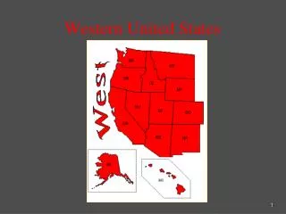
Alaska Washington Montana Oregon Idaho Wyoming Label the States Nevada Utah Colorado California Arizona New Mexico Hawaii
Arctic Ocean Alaska Bering Sea Washington Columbia River Missouri River Montana Gulf of Alaska Oregon Idaho Wyoming Rocky Mountains Pacific Ocean Great Salt Lake Nevada Utah Colorado Physical Features California Colorado River Arizona New Mexico Hawaii
Western United States • There are 13 states in the Western Region • It is the largest region of the United States
Physical Features • The Rocky Mountainsare North America’s largest mountain range. • Melting snow from the Rockies formed rivers including the Rio Grande, The Missouri, and The Colorado • Landforms vary greatly • Good land for farming • Tall Grass Prairiesfor ranching • Coastal areasfor fishing • Great Plains • Deserts • Basins • Volcanoes
Alaska • Purchased from Russia in 1867 for $7.2 million • William Seward (Sec. of State) bought it • the 49th state - 1959
The Hawaiian Islands • 8 major islands; 100 smaller • actually volcanic mountains “poking” through Pacific • 1900 became USA territory; 1959 became USA state (50th state)
Climate/Weather What is this? The Pacific Ring of Fire The Ring of Fire 2:50
Climate/Weather • Pacific Ring of Fire • Region is subject toearthquakes, volcano eruptions, and hot spots(In middle of a plate where magma reaches surface. Warms water and shoots steam into air known as Geysers) • Extreme variance in seasonal temperature and rainfall(Alaska to Hawaii!) • Semiarid Climatein general in western states that fall in the contiguous 48 states sem·i·ar·id (s m - r d) adj. Characterized by relatively low annual rainfall of 25 to 50 centimeters (10 to 20 inches) and having scrubby vegetation with short, coarse grasses; not completely arid.
Climate/Weather The Pacific Ring of Fire Plate Tectonics 3:49
Climate/WeatherThe Ring of Fire Ring of Fire explanation 1:33 The large series of volcanoes (some active) encircling the Pacific Ocean are referred to as being part of the Ring of Fire, and notorious for frequent earthquakes and volcanic eruptions. The Ring of Fire, coinciding with the edges of one of the world's main tectonic plates, (the Pacific Plate) contains over 450 volcanoes and is home to approximately 75% of the world's active volcanoes. Nearly 90% of the world's earthquakes occur along the Ring of Fire; most recently, the devastating quakes in Chile, Japan and New Zealand. Ring of Fire information 2:11 (earthquakes)
EarthquakesTop Earthquake States 1. Alaska 2. California 3. Hawaii 4. Nevada 5. Washington 6. Idaho 7. Wyoming 8. Montana 9. Utah 10. Oregon
VolcanoesPacific Ring of Fire Cycle of Heated Gas 1:14
VolcanoesMt. St. Helens, Washington State • The 1980 eruption of Mount St. Helens was the most significant to occur in the contiguous 48 U.S. states in recorded history • The eruption was preceded by a two-month series of earthquakes and steam-venting episodes, caused by an injection of magma at shallow depth below the mountain that created a huge bulge and a fracture system on Mount St. Helens' north slope. • An earthquake at 8:32 a.m. on May 18, 1980, caused the entire weakened north face to slide away, suddenly exposing the partly molten, gas- and steam-rich rock in the volcano to lower pressure. The rock responded by exploding into a very hot mix of pulverized lava and older rock that sped toward Spirit Lake so fast that it quickly passed the avalanching north face. VIDEOS: Mt. Saint Helens 1:40 devastation to animals/people Mt. Saint Helens 1:49 Landslide Mt Saint Helens 7:31
Hot SpotsYellowstone National Park “Old Faithful” • The Old Faithful geyser in Wyoming's Yellowstone National Park erupts about once every 65 minutes, much to the delight of tourists. • The water ejected during each eruption is at or near the boiling point, often reaches a height of 50 meters (approximately 170 feet), and has an estimated volume of 45,000 liters (12,000 gallons). WEBCAM Video WEBCAM main page
Economy of the WestResources • Timber • Minerals • Gold Rush in California & Alaska • Oil • Alaska pipeline • Natural gas • Fish • Dairy • Pineapple/Sugarcane (Hawaii)
Economy of the WestIndustry Technology • Movie industry • Computers in the Silicon Valley • Computer equipment • Telecommunications The area around Los Angeles also was a major center for theaerospace industryby World War II, though Boeing, located in Washington state would lead the aerospace industry Federal Government • Military bases • Much of land owned by government • Flat deserts good for testing planes and missiles • Supports scientific research
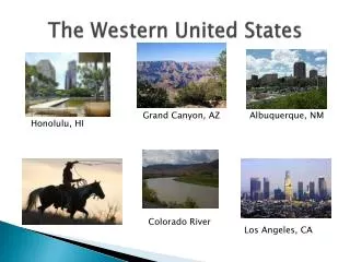
Places of Interest Some of thelargest cities include: • Los Angeles (CA) • San Francisco (CA) • Phoenix (AZ) • Seattle (WA) • Denver (CO) • Las Vegas (NV) • Salt Lake City (UT)
Historic Route 66 Texas to California start at 4:25
Places of InterestLandmarks/Tourist Attractions • Grand Canyon • Hoover Dam • Pearl Harbor • Yellowstone National Park • Las Vegasentertainment • Seattle Space Needle • San FranciscoGolden Gate Bridge and Chinatown • Mount St. HelensOnly erupting volcano in contiguous 48 • Mount McKinley
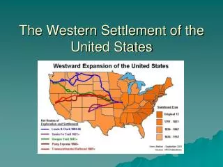
HistoryPeople • Native Americans(Plains Indians) • Inuit survived in Alaska by hunting and fishing. • Hawaii settlers came from South Pacific islands • Large Indian reservation • European Settlersmoved west as part of westward expansion and to escape from the Dust Bowl • Spanish Settlersfrom Texas and Mexico • Asian Immigrantscame to work in mines and build railroads and now contribute heavily to technology industry • Hawaii settlers came from South Pacific islands • Hawaii is the only state in the union in which Asian Americans outnumber white American residents.
HistoryCulture • Culturally distinctive points include the largeMormon populationin the Mormon Corridor, including southeastern Idaho, Utah, Northern Arizona and Nevada • The image of the cowboy, the homesteader and westward expansion took real events and transmuted them into a myth of the west which has influenced American culture since at least the 1920s. • Western businessmen promoted U.S. Route 66 as a means to bring tourism and industry to the West.
HistoryEvents • 1849: California Gold Rush • Compromise of 1850(California admitted to Union as non-slave state) • Gadsden Purchase • 1930’s: Dust Bowl • 1989: Exxon Valdez Oil Spill