Download
1 / 13
130 likes | 235 Vues
This briefing by Roque Vinicio Céspedes, conducted on February 14, 2011, provides an in-depth look at various weather forecasting tools and methodologies. It covers computer models run by the National Center for Environmental Prediction (NCEP) and other agencies, discussing how statistical guidance and Model Output Statistics (MOS) are used to determine accurate point forecasts for specific locations. The briefing also explains essential abbreviations related to meteorological data, including wind direction, temperature, and probabilities of precipitation, along with time conversions necessary for accurate forecasting.

E N D
A Very Brief Overview of Weather Forecasting Tools Briefing by: Roque Vinicio Céspedes February 14, 2011
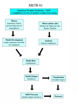
Computer Guidance Forecast • The National Center for Environmental Prediction (NCEP) and other agencies run computer models to forecast the weather. • Statistical guidance is often used as a first guess for a weather forecast. • Guidance can be decoded to provide the information necessary to make a forecast for “a point forecast” for a city.
Model Output Statistics (MOS) • Computer models are never perfect. • They have systematic errors (“biases”) that depend on the place and time, and these need to be corrected. • MOS = a blend of computer model output with historical forecast data, used to predict meteorological conditions at the surface.
Note about NWS weather station codes… • This is usually the same as the airport codes (usually, but not always the first three letter of a city name), prefixed by the letter “K”. • For Miami, FL, this is “KMIA”.
Date and Time Conversions • Meteorological Information is given for UTC time. This is the time zone associated with the prime Meridian • EST= UTC – 5 Hours 1200Z = 8:00 AM in Miami 1500Z = 11:00 AM CST in Michigan 0600Z = 12:00 PM PST in California
Meteorology Wind Direction 180 = From the South 1 kts = 1.15 mph 090 = From the East 270 = From the West 000 = From the North Wind Speed is in KNOTS (kt)
MOS Abbreviations • DT = The day of the month, denoted by the standard three or four letter abbreviation • HR = Hour of the day in UTC time. This is the hour at which the forecast is valid, or if the forecast is valid for a period, the end of the forecast period. • N/X = nighttime minimum/daytime maximum surface temperatures. • TMP = surface temperature valid at that hour. • DPT = surface dewpoint valid at that hour. • CLD = forecast categories of total sky cover valid at that hour. • WDR = forecasts of the 10-meter wind direction at the hour, given in tens of degrees. • WSP = forecasts of the 10-meter wind speed at the hour, given in knots. • P06 = probability of precipitation (PoP) during a 6-h period ending at that time. • P12 = PoP during a 12-h period ending at that time. • Q06 = quantitative precipitation forecast (QPF) category for liquid equivalent precipitation amount during a 6-h period ending at that time. • Q12 = QPF category for liquid equivalent precipitation amount during a 12-h period ending at the indicated time. • SNW = snowfall categorical forecasts during a 24-h period ending at the indicated time. • T06 = probability of thunderstorms/conditional probability of severe thunderstorms during the 6-hr period ending at the indicated time. • T12 = probability of thunderstorms/conditional probability of severe thunderstorms during the 12-hr period ending at the indicated time. • POZ = conditional probability of freezing pcp occurring at the hour. • POS = conditional probability of snow occurring at the hour. • TYP = conditional precipitation type at the hour. • CIG = ceiling height categorical forecasts at the hour. • VIS = visibility categorical forecasts at the hour. • OBV = obstruction to vision categorical forecasts at the hour.
Prerecorded Demo http://www.youtube.com/watch?v=GYad71lj-m0