
Topographic Base Maps
Topographic Base Maps. Objective – Displays surface features (topography, roads, lakes & river, cultural features) and a grid system (TRS, UTM, Lat/Lon) that allow one to readily locate the geologic features portrayed Best choice of base map is largely dependent on the map scale .

Topographic Base Maps
E N D
Presentation Transcript
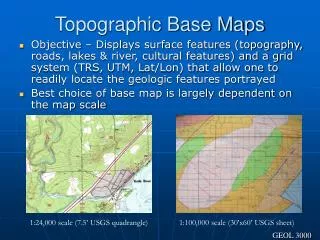
Topographic Base Maps • Objective – Displays surface features (topography, roads, lakes & river, cultural features) and a grid system (TRS, UTM, Lat/Lon) that allow one to readily locate the geologic features portrayed • Best choice of base map is largely dependent on the map scale 1:24,000 scale (7.5’ USGS quadrangle) 1:100,000 scale (30’x60’ USGS sheet) GEOL 3000
Map Projections Mercator Conical Transverse Mercator Polyconic
Universal Transverse Mercator (UTM) Grid Two Versions of North American Datum (NAD) grid – 1927 and 1983
Surveyed Grid Township, Range, Section Township ~36 sq. miles Section ~1 sq. mile
Grids on Topographic Maps Township Boundary Latitude Longitude
Elements of the Topographic Map USGS Topographic Map Symbol Website <click here>
Topographic Contour Linesconnects points of equal elevation • Rules: • Lines never cross • Lines never end • Lines “V” upstream • Lines encircle hills • and depressions
Standard Topographic Basemap Scales 7.5’ Quadrangles 1:24,000 1” = 2000 feet See DNR Maps Website for MN topo maps <click here> 1° x 2 ° Sheets 1:250,000 1” = 4 miles Also: 30’x60’ sheets, 1:100,000, 1”=1.5 miles


