Unveiling Seamount Mysteries: Exploration and Formation
160 likes | 278 Vues
Explore the formation, structure, and distribution of seamounts. Learn about Hawaii-type and Puka Puka chains, internal structure, and exploration strategies using advanced technologies like Google Earth and satellite altimetry.

Unveiling Seamount Mysteries: Exploration and Formation
E N D
Presentation Transcript
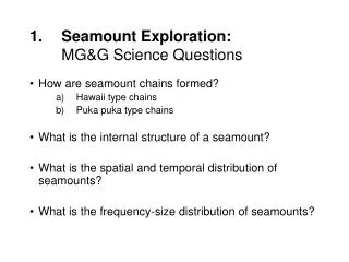
Seamount Exploration:MG&G Science Questions • How are seamount chains formed? • Hawaii type chains • Puka puka type chains • What is the internal structure of a seamount? • What is the spatial and temporal distribution of seamounts? • What is the frequency-size distribution of seamounts?
Seamount Exploration:Exploration Strategies • Existing data US Navy proprietary, Medea and Red Dots Other countries proprietary • Ships of opportunity and Google Earth (GE) GE to encourage data sharing GE as a real-time survey tool • Satellite altimetry Cryosat II (launch Nov. 2009) Other non-repeat orbit altimeters
Hawaii-type Chains Wessel & Kroenke, 1997 Nature Wessel & Kroenke, 2008 JGR
Puka puka type chains Sandwell and Fialko, 2006
Louisville Ridge, SW Pacific Te=8 km Contreras-Reyes, Grevemeyer, Watts, Planert, Flueh, Peirce (Submitted)
Geographic Distribution of Seamounts Wessel and Lyons, 1997
spatial and temporal distribution of seamounts - OceanicTe Watts, Sandwell, Smith, and Wessel, JGR, 2006
Size Distribution of Seamounts Wessel JGR, 2001
Seamount Exploration:Exploration Strategies • Existing data US Navy proprietary, Medea and Red Dots Other countries proprietary • Ships of opportunity and Google Earth (GE) GE to encourage data sharing GE as a real-time survey tool • Satellite altimetry Cryosat II (launch Nov. 2009) Other non-repeat orbit altimeters
MEDEA: Scientific Utility of Naval Environmental Data, (Mitre, Co., June, 1995)
CryoSat ESA’s Ice Mission Mark Drinkwater Mission Experts Division www.esa.int/livingplanet/cryosat