Download
1 / 24
250 likes | 460 Vues
Landsat Data Continuity Mission . January 9, 2007 Bill Ochs LDCM Project Manager. Topics. NASA LDCM Organization LDCM History LDCM Observatory Overview, Operations Concept, Requirements Operational Land Imager Procurement Spacecraft and Mission Operations Element Procurements

E N D
Landsat Data Continuity Mission January 9, 2007 Bill Ochs LDCM Project Manager
Topics • NASA LDCM Organization • LDCM History • LDCM Observatory Overview, Operations Concept, Requirements • Operational Land Imager Procurement • Spacecraft and Mission Operations Element Procurements • NASA/USGS Partnership • LDCM Launch Readiness Date
LANDSAT DATA CONTINUITY MISSION - CODE 427 Project Manager - Bill Ochs Deputy Project Manager - Del Jenstrom DPR/Resources - Michele Marrie Secretary - JoAnn Brasted Project Science Office Jim Irons NASA HQ Program Exec Ed Grigsby USGS Representative(s) Mike Headley, Ray Byrnes Deputy - J. Masek Instruments - P. Dabney Data Acquisition - Vacant SSAI Contractors RA - G. Baldessari Project Support Manager J. Stevens-Reid/SGT (Acting) Financial Manager Carolyn Ellenes Systems Assurance Mgr. - Jack Ellis Safety Manager - Dick Bolt Schedules/EVM - J. Chipouras /Swales CM - Vacant RA – S. Sumner /VSI Procurement Manager - T. Seidel Contracting Officer - P. Dombrowski Contracting Officer - F. Johnson Systems Manager Evan Webb Mission Systems Engineer - T. Grems /AI Solutions Systems Engineer – S. Bailey, B. Patschke, M. Goldberg /MITRETEK Risk Manager - C. Knapp /Swales MIT/LL - D. Lencioni (lead) Education & Public Outreach Anita Davis/SSAI L. Rocchio /SSAI J. Allen /SSAI Observatory Manager Bill Anselm Cal/Val Manager B. Markham Land Imager Manager J. Murphy Ground Systems Mgr Vicki Zanoni Mission Ops Mgr Vacant Discipline Engrs Discipline Engrs Gnd & Ops Consultant - S Coyle GS Test Lead - B. Pumphrey Ops. Eng - R. Shendock Moe COTR- Vacant Sys Eng - Vacant I&T Mgr - Nancy Stafford Discipline Engrs Cal/Val Engr - B. Barnes /SAIC Cal/Val - J. Storey /SAIC SSAI Contractors Last Updated : 12/2006
LDCM History • Landsat 7 launch on April 15, 1999 • Release of LDCM Data Buy RFI - June, 1999 • Earth Observing-1 satellite launch - Nov. 21, 2000 • Advanced Land Imager (ALI) aboard • Release of Data Buy Implementation Phase RFP on Jan. 06, 2003 • In Sept. 2003, LDCM Data Buy solicitation cancelled • Vendor failed to take an equity stake required to offer a true public-private partnership • Gov’t accepted all the risk • In December 2003, EOP established the Landsat/NextView Interagency Working Group (IWG) to study: • Combining LDCM and National Geospatial-Intelligence Agency (NGA) NextView requirements • USG owned/operated LDCM system • Public/Private partnership for LDCM system • Hosted LDCM payload on USG/Commercial satellites
LDCM History • Memorandum from EOP/OSTP issued on Aug. 13, 2004 on Landsat Data Continuity Strategy • Summarizes outcome of interagency discussions on continuity of Landsat data • Departments of Defense, the Interior, Commerce, and NASA have agreed to: • Transition Landsat measurements to an operational environment on NPOESS • Plan to incorporate a Landsat imager on the first NPOESS spacecraft • Further assess options to mitigate the risks to data continuity prior to the first NPOESS-Landsat mission, including a “bridge mission” • Meeting with EOP/OSTP on Nov. 22-23, 2004 to provide LDCM Status Update • Departments of Defense, the Interior, Commerce, and NASA directed to incorporate OLI onto NPOESS 2130 S/C • No longer continue to pursue “bridge mission” • OLI NPOESS accommodation study conducted between January and May of 2005 • Included GSFC, IPO, NGST, USGS
* Includes Solid State Recorder and all accommodation hardware where required. LDCM History
LDCM History • July 2005, NASA HQ met with EOP/OSTP to explain complexities of flying on NPOESS • Dec. 2005, EOP/OSTP issued memorandum on Landsat Data Continuity Strategy Adjustment • Landsat instrument no longer on NPOESS • NASA to acquire single Landsat mission and deliver data to USGS • USGS will operate Landsat and collect, process, distribute, and archive Landsat data • Jan. 2006, Memorandum from NASA HQ on LDCM Procurement Strategy • Procure a free-flyer spacecraft (Firm Fixed Price) • Single prime mission contractor responsible for: • Spacecraft • Instrument • Observatory I&T/Launch Site Support • Mission Operations Element • On-Orbit Sustaining Engineering
LDCM History • Sept. 2006, LDCM Procurement Strategy Change • Multiple contracts • Operational Land Imager (OLI) • Multi-spectral, moderate resolution (circa 30m), visible and near-infrared sensor capable of providing on average 400 Landsat scenes (177km x 170km) per day to US archive • Spacecraft using Rapid Spacecraft Development Office (RSDO) catalog contract • RSDO issued an “On-Ramp” to the RSDO Rapid II catalog in fall of 2006 to maximize competition for the LDCM spacecraft procurement • Mission Operations Element (MOE). • Mission scheduling (not to include long-term and daily image collection planning and prioritization) • Command and control • Long-term trending and analysis • Flight dynamics capabilities
LDCM Observatory Overview, Operations Concept, and Requirements
LDCM Observatory Spacecraft Bus S/C C&DH S/C SSR S/C S-band U/L & D/L Narrowband Command & Eng Telemetry Uplink / Downlink Cmd/Tlm S/C X-band D/L Cmd/Tlm Wideband Science Data Downlink High-Speed I-SSR Data Bus (HSIDB): Format TBD 1553 Bus Instrument SSR (I-SSR) Cmd/Tlm & Ancillary Data High Speed Science Data Bus (HSSDB): Format TBD Cmd/Tlm OLI (If TIRS is confirmed For LDCM) TIRS Cmd/Tlm LDCM Observatory Overview
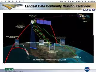
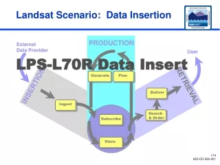
User Community EROS LDCM Operations Concept wideband data narrowband data TT&C S-band link (L&EO & C) Space Segment interface Real-time link International Cooperators (ICs) Launch Segment Stored + Real-time TT&C S-band link Photons Data Processing and Archive Segment Flight Operations Segment Collection Activity Planning LDCM Ground Network User Portal Mission Operations Element Calibration / Validation Storage & Archive NASA Provided USGS Provided NASA/USGS Provided Image Processing
NASA/DOI/USGS MOU Land Remote Sensing Policy Act, PDD NSTC-3, etc. External & NASA Institutional Requirements (GOLD Book, GEVS, GPRs, NPRs) NASA Headquarters & NASA Center Control (Level 1) LDCM/USGS Implementation Agreement LDCM Level 1 Requirements Project Control (Level 2) LDCM Science & Mission Requirements Document (SMRD) LDCM Operations Concept Project Control (Level 3) Flight Operations Segment Requirements Document Data Processing & Archive (DPA) Segment Requirements Document Launch Services Segment Requirements Document LDCM Instrument Mission Assurance Requirements (LDCM I-MAR) LDCM Environmental Verification Requirements (LEVR) Special Calibration Test Requirements (SCTR) LDCM Interface Requirements Document (LDCM IRD) Mission Operations Element Requirements Document Key: Collection Activity Planning (CAP) Element = Joint Government Document OLI Requirements Document TIRS Requirements Document RSDO Bus Requirements Document = NASA-Document = USGS- Document LDCM Ground Network = OLI Contractual Document = Launch Provider Document Contractor Control (Level 4 & lower) = MOE Contractual Document = RSDO Contractual Document LDCM Requirements Hierarchy
OLI Requirements • OLI is a multi-spectral, moderate resolution (30m GSD), visible and near-infrared sensor capable of providing on average 400 Landsat scenes (185km x 180km) per day to US archive • 4 visible bands (costal/aerosol, red, green, blue) • 1 near-infrared (IR) band • 2 shortwave IR bands • 1 cirrus cloud detection band • 1 panchromatic band at higher resolution (15m) for image sharpening • OLI requirements are based on original LDCM data specification, therefore the sensor should be capable of providing data with the quality of previous Landsat VNIR/SWIR data
OLI Contract Overview OLI Contract Instrument, Observatory I&T/Launch Site Support, & On-Orbit Sustaining Engineering Mission Responsibility - NASA Mission Responsibility - USGS IOC Complete 10/2011 End Of Basic Contract 10/2016 OLI Delivery 9/2010 Contract Award 6/2007 Launch 7/2011 Task Specific Effort +On-Orbit Incentives Cost Plus Award Fee On-Orbit Sustaining Engineering (5 yrs. + five 1-year options for extended operations) OLI Design, Development, Observatory I&T, Launch Site Support, & IOC Participate in Bus Interface Studies Transfer Contract To USGS
LDCM Spacecraft • RSDO S/C • “On-Ramp” to Rapid II Catalog to permit all qualified spacecraft vendors to be added to the current RSDO catalog – On-Ramp Closed Dec. 15th • New Rapid II catalog available – March 2007 • Multiple vendors will be selected for 4 month study – May 2007 • Study topics include communications architecture, instrument interface, mission operation element interface, I&T planning, MAR/”Golden Rules”/LDCM Environmental Verification Requirements, etc. • Final Request For Offer release and selection after study phase • Contract includes: • Spacecraft • Observatory I&T • Launch Site Activities • On-Orbit Sustaining Engineering • 5 1-year options for additional On-Orbit Sustaining Engineering • Spacecraft under contract – Nov. 2007
Mission Operations Element (MOE) • Contract includes: • Command & Control, Mission Scheduling, Long-Term Trending and Analysis, and Flight Dynamics capabilities • Support for Observatory I&T/Launch Site • On-Orbit Sustaining Engineering • 5 1-year options for additional On-Orbit Sustaining Engineering • RFI was issued on Nov. 22nd • Requested info included: • Reference architecture, use of COTS, approaches to I&T with spacecraft and ops team, etc. • Responses received Dec. 14th • RFP released in early summer • Detailed schedule is still under review • MOE under contract – Dec. 2007 • Detailed schedule is still under review
NASA/USGS Partnership • NASA and DOI USGS are identified as the Landsat Program Management team under authority of U.S. Code Title 15, Chapter 82, “Land Remote Sensing Policy” and Presidential Decision Directive NSTC-3, “Land Remote Sensing Strategy,” • NASA Responsibilities • Development of • Space Segment, Launch Segment, and the Mission Operations Element (MOE) • Serve as the system integrator for the entire LDCM and lead the missions systems engineering effort • Lead Mission Operations through the completion of the on-orbit checkout period • USGS Responsibilities • Development of • Ground System (comprised of the Flight Operations and Data Processing and Archive Segments), excluding procurement of the MOE • LDCM mission operations, after the completion of the on-orbit checkout period • Accept and execute all responsibilities associated with the transfer of the LDCM Operational Land Imager (OLI) instrument, spacecraft bus and Mission Operations Element contracts from NASA following on-orbit acceptance of the LDCM system including assuming contract management
Launch Readiness Date • Targeted Launch Readiness Date • July 2011 • Critical Path to Launch • Instrument Delivery • 39 mos. after Contract Award (9/2010) • Challenge • Enable an instrument in delivery in 39 months but still meeting all the technical and programmatic requirements defined in the RFP package • Schedule is only attainable through a strong partnership between industry and NASA