Census Geographic Concepts
This overview explores the concept of census tracts and other geographic areas within Lafayette County, Mississippi. Census tracts are designed as permanent statistical subdivisions, typically encompassing 1,000 to 8,000 residents. Each tract maintains consistent boundaries, facilitating detailed population analysis. The text discusses the hierarchical structure of census geographic entities, including blocks and block groups, which are essential for accurate data tabulation. Additionally, it highlights the importance of these areas in community planning and resource allocation.

Census Geographic Concepts
E N D
Presentation Transcript
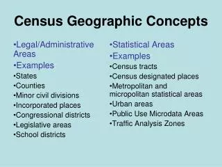
Legal/Administrative Areas Examples: States Counties Minor civil divisions Incorporated places Congressional districts Legislative areas School districts Statistical Areas Examples: Census tracts Census designated places Metropolitan and micropolitan statistical areas Urban areas Public Use Microdata Areas Traffic Analysis Zones Census Geographic Concepts
Census Tracts • Small, relatively permanent statistical subdivisions of a county • Relatively consistent boundaries over time • Size: optimally 4,000 people; range between 1,000 and 8,000 • Approximately 65,000 census tracts in U.S. • Defined nationwide for the first time in Census 2000; however Block Numbering Areas (BNAs) and tracts covered the entirety of the nation in 1990
Block Groups Groups of blocks sharing first digit of block number Smallest units for tabulation of sample data Population ranges from 600 to 3,000 Nest within census tracts Small Geographic Areas • Blocks • Smallest units for 100% data tabulation • Cover entire nation • Nest within all other types of geographic areas • Generally bounded by visible features or political boundaries