Download
1 / 20
200 likes | 367 Vues
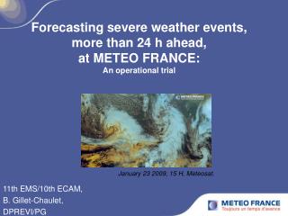
Forecasting severe weather events, more than 24 h ahead, at METEO FRANCE: An operational trial. 11th EMS/10th ECAM, B. Gillet-Chaulet, DPREVI/PG. January 23 2009, 15 H, Meteosat. Context and motivations :. Beyond the short range (24 H) at METEO FRANCE

E N D
Forecasting severe weather events, more than 24 h ahead, at METEO FRANCE:An operational trial 11th EMS/10th ECAM, B. Gillet-Chaulet, DPREVI/PG January 23 2009, 15 H, Meteosat.
Context and motivations : • Beyond the short range (24 H) at METEO FRANCE • No equivalent oper. warning procedures available (not yet…) • NWP improvements during recent years • « Predictability » => Express uncertainty Xynthia windstorm : 3 days in advance !
Approach and Product : • occurrence of “severe weather events” • Definition : orange or red level, “Vigilance” procedure, 24 h ahead. - Violent winds, - Heavy rains *, (not floods). - Violent thunderstorms, - Snow/Ice. • (not temperatures). • For one entire Day (00 to 24H), D+2, D+3… • Zoning (fixed), administrative regions (significant) • Risk Index (usual thunderstorms/fogs…) • => Quantify the risk Risk Scale: 0, no risk, 1, low, 2, medium, 3, high.
Approach and Product : • In the past, (CNP -National Service- : December. 2004, ¼ de France). • Reference/”truth” data : “Vigilance” level . • Example : How much is a “low” risk (1), • Over the north-eastern regions, • Parameter • D+2 ?
Approach and Product : • In the past, (CNP -National Service- : December. 2004, ¼ de France). • Reference/”truth” data : “Vigilance” level . • Example : How much is a “low” risk (1), • Over the north-eastern regions, • Parameter • D+2 ?
Approach and Product : • In the past, (CNP -National Service- : December. 2004, ¼ de France). • Reference/”truth” data : “Vigilance” level . • Example : How much is a “low” risk (1), • Over the north-eastern regions, • Parameter • D+2 ? nothing nothing nothing nothing 20 % 1/5 in this example
Approach and Product : D+2, Regions (in total): Period: 1st Nov – 1st April 2004/2005 to 2009/2010 (Winter before last) Forecast Climatic frequency No Risk Low Medium High N Cases
Approach and Product : D+2, Regions (in total): Period: 1st Nov – 1st April 2004/2005 to 2009/2010 (Winter before last) Forecast Rare phenomena: Significant ? Climatic frequency No Risk Low Medium High And Feed-back (Low risk ?) N Cases
Approach and Product : D+2, Regions (in total): Latest Winter : 1st Nov – 1st April 2010/2011 Reliable ! Forecast Climatic frequency No Risk Low Medium High N Cases
Approach and Product : Sample size, season, region, range, discrimination between indexes… “Calibration” (« Dressing ») : No Risk, Low, Medium, High. No Risk, Low, Medium, High.
Examples : Xynthia Valid for : Sunday 28/02/2010 D+3 D+2 Calibrated Scale: No Risk Low Medium High 3 days ahead 2 days ahead
South-East, 7/09/2010 Valid for : Tuesday 7/09/2010 D+3 D+2 Calibrated Scale: No Risk Low Medium High 3 days ahead 2 days ahead Lyon, daily rainfall 104,1 mm Absolute Record (previous 1935)
Paris under the snow, 8/12/2010 Valid for : Wednesday 8/12/2010 D+3 D+2 Calibrated Scale: No Risk Low Medium High 3 days ahead 2 days ahead FRANCE - A la mi-journée, la neige continuait de tomber sur la place de la Concorde à Paris. L'Île-de-France, comme dix-neuf autres départements, ont été placés par Météo France en vigilance orange neige et verglas ce mercredi. AFP/ Médina DE MIGUEL
Events point of view (ROC) : D+2, Regions (in total), Period 2004-2011 (01/11 – 01/04) : Probability of false detection (POFD) (False alarm rate) : Probability of detection (POD) ( Hit Rate) : Scale No Risk, Low, Medium, High. 69% 7% bad good Observed Not Observed Scale /10 !
Events point of view (ROC) : D+2, Regions (in total), Period 2004-2011 (01/11 – 01/04) : Probability of false detection (POFD) (False alarm rate) : Probability of detection (POD) ( Hit Rate) : Scale No Risk, Low, Medium, High. 69% 7% bad good Observed Not Observed AROC = 0.81 ( 0.84 , 0.79 ) Scale /10 ! Scale No Risk, Low, Medium, High. 6% 0, %
Conclusion : • Thanks to recent improvements (research, operational…) Signal at D+2, D+3, and beyond ! (7 Day test…) (Non deterministic) • Proposal of synthesis… -> • Since 1st of March 2010, daily issue (14 H 30 local time) : • COGIC, SCHAPI, CNIR, CRIR, INVS (feed back ?) • CNP production (regions collaboration), • Available on the internal Website http://previ-gene/ • Similar products already available on several Websites…(MET OFFICE)
back One Context
Abstract: Title : Forecasting severe weather events, more than 24 hours ahead, at METEO FRANCE: An operational trial. For the short range, typically 24 hours ahead, severe weather forecast procedures have been in effect for a long time. The French “vigilance” watch map celebrates its tenth anniversary in 2011. It puts in concrete form the first mission of METEO FRANCE in the domain of protection of people and goods, and has proved generally successful. Improvements in numerical weather prediction during recent years, now enable a focus on forecasting dangerous weather phenomena at longer ranges (e.g. within the Medium Range) and beyond the requirements for triggering a “vigilance” warning. However, this can not be just a simple extension of the validity of the vigilance watch map, because uncertainty generally quickly increases with the forecast range and makes a deterministic approach difficult. A systematic production, experienced on a daily basis since December 2004 at the national forecasting service of METEO FRANCE has tried to forecast the risk of occurrence of dangerous phenomena (violent winds, heavy rain, violent thunderstorms, snow/ice) that might reach orange or red warning levels of “vigilance”, several days ahead. Every morning, a risk index has been assessed by the forecasters, based on their study of deterministic models, numerous EPS products, for a given day from D+2 until D+7, and over given geographical areas of France. The index has been selected from no risk, unlikely, likely, certain. After choosing a reference or “truth” data (the colour of “vigilance” actually issued at the considered scale), accuracy and skill of the forecast has been shown. Then the idea has been to provide, in real time, the probabilities corresponding to the reliability of the chosen index taking into account the phenomenon, the samples representativeness and the discrimination between indexes. Since March 2010, encouraging results have allowed us to propose institutional partners of METEO FRANCE a forecast of the risk of occurrence of these phenomena in terms of probabilities at the scale of the administrative French regions for D+2 and D+3. First feed-back from the users is interesting, but shows that probabilities must be correctly interpreted. In fact, one still thinks that a probability of 50% corresponds to the toss of a coin, whereas it is significantly high when the climatological frequency of the phenomenon is low. Furthermore, decision makers have to learn how to make best use of this new type of information.
Résumé : Ce travail concerne la prévision des phénomènes météorologiques présentant un risque pour la sécurité des personnes et des biens. A vingt-quatre heures d’échéances, des procédures d’avertissement existent depuis longtemps : la « Vigilance » de Météo France fête ses dix ans d’existence en 2011. Les progrès notables réalisés en prévision ces dernières années permettent d’anticiper ces phénomènes à des échéances plus lointaines. Cependant, leur faible prévisibilité empêche une approche déterministe. Une production systématique, quotidienne, expérimentée depuis décembre 2004 à DPREVI/PG, s’attache à prévoir le risque d’occurrence des phénomènes « Vent violent, Pluie-innondation, Orages, Neige-verglas » susceptibles de relever des niveaux de vigilance orange ou rouge, à plusieurs jours d’échéance. En mars 2010, les résultats encourageants ont permis de proposer aux partenaires institutionnels de Météo France une prévision du risque d’occurrence de ces phénomènes, assortie d’une probabilité calibrée, à l’échelle des régions économiques françaises, pour les journées J+2 et J+3.