Enhancing Storm Water Management in Old Towne, Havre de Grace, Maryland
This project focuses on mapping and improving storm water management facilities in Old Towne, Havre de Grace, Maryland. Utilizing GIS technology, three-dimensional elevation maps, and data from the EPA's Watershed Implementation Plan, we identified drainage areas and potential storm water structure locations. Analysis revealed the current system's limitations in managing runoff, particularly in flooding incidents along Lily Run. Recommendations include additional storm water facilities to enhance water quality before entering the Chesapeake Bay watershed, informing city planning and emergency preparedness.

Enhancing Storm Water Management in Old Towne, Havre de Grace, Maryland
E N D
Presentation Transcript
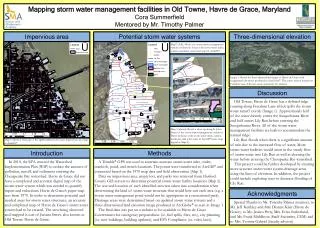
Mapping storm water management facilities in Old Towne, Havre de Grace, Maryland Cora Summerfield Mentored by Mr. Timothy Palmer Impervious area Potential storm water systems Three-dimensional elevation Map 2 (left): Shows the storm water management system in Havre de Grace with storm water inlets, outlets, manholes, and water ways in ArcGIS®. Image 1: Shows the three-dimensional image of Havre de Grace with exaggerated elevations produced in ArcGlobe®. The center crest is located on Freedom Lane. This was used extensively for analysis. Discussion Old Towne, Havre de Grace has a defined ridge running along Freedom Lane which splits the storm water runoff evenly (Image 1). Approximately half of the water directly enters the Susquehanna River and half enters Lily Run before entering the Susquehanna River. All of the storm water management facilities are built to accommodate the natural ridge. Lily Run floods when there is a significant amount of rain due to the increased flow of water. More storm water facilities would assist in the steady flow of storm water into Lily Run as well as cleaning the water before entering the Chesapeake Bay watershed. This project could be further developed by creating more accurate storm water system drainage areas using the lines of elevation. In addition, the project could include exploring ways to decrease flooding of Lily Run. Map 3 (above): Shows a close-up along St. John Street of the storm water management system in Havre de Grace with storm water inlets, outlets, manholes, and water ways in ArcGIS®(same map legend as Map 2). Map 1: Shows a close-up of the updated Havre de Grace impervious area map in ArcGIS®. Introduction Methods In 2010, the EPA enacted the Watershed Implementation Plan (WIP) to reduce the amount of pollution, runoff, and sediments entering the Chesapeake Bay watershed. Havre de Grace did not have a completed and accurate digital map of the storm water system which was needed to quantify inputs and reductions. Havre de Grace’s paper map was from 1970. In order to determine potential and needed areas for storm water structures, an accurate and completed map of Havre de Grace’s storm water system had to be created. The area being observed and mapped is east of Juniata Street, also known as Old Towne, Havre de Grace. A Trimble®GPS was used to ascertain accurate storm water inlet, outlet, manhole, pond, and trench locations. The points were transferred to ArcGIS® and connected based on the 1970 map data and field observation (Map 1). Data on impervious area, empty lots, and parks was retrieved from Harford County GIS servers to determine potential storm water facility locations (Map 2). The size and location of each identified area was taken into consideration when determining the kind of storm water structure that would best suit each area (e.g. a storm water management pond would not be appropriate in a recreational park). Drainage areas were determined based on updated storm water systems and a three-dimensional land elevation image produced in ArcGlobe® as seen in Image 1. The final data was put on a website to be available to Havre de Grace Government for emergency preparedness (i.e. fuel spills, fires, etc.), city planning (i.e. new buildings, building updates), and EPA Compliance (i.e. rules, laws). Acknowledgments Special Thanks to Mr. Timothy Palmer (mentor), to Mr. Jeff Keithley and Mrs. Dianne Klair (Havre de Grace), to Ms. Jessica Petty, Mrs. Erica Sutherland, and Mr. Frank Middleton (Staff Scientists, CEM) and to Mrs. Yvonne Gabriel (faculty advisor).