Download
1 / 1
10 likes | 96 Vues
Explore the disappearance of marsh vegetation in Herring River and Red River, Harwich, analyzed by Coastal Ecologist Ron Rozsa in 2002. Discover the impact on Spartina alterniflora and Distichlis spicata. Could submergence be the cause?

E N D
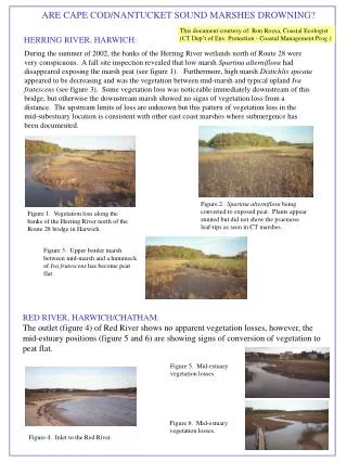
ARE CAPE COD/NANTUCKET SOUND MARSHES DROWNING? This document courtesy of: Ron Rozsa, Coastal Ecologist (CT Dep’t of Env. Protection - Coastal Management Prog.) HERRING RIVER, HARWICH: During the summer of 2002, the banks of the Herring River wetlands north of Route 28 were very conspicuous. A fall site inspection revealed that low marsh Spartina alterniflora had disappeared exposing the marsh peat (see figure 1). Furthermore, high marsh Distichlis spicata appeared to be decreasing and was the vegetation between mid-marsh and typical upland Iva frutescens (see figure 3). Some vegetation loss was noticeable immediately downstream of this bridge, but otherwise the downstream marsh showed no signs of vegetation loss from a distance. The upstream limits of loss are unknown but this pattern of vegetation loss in the mid-subestuary location is consistent with other east coast marshes where submergence has been documented. Figure 2. Spartina alterniflora being converted to exposed peat. Plants appear stunted but did not show the praemose leaf-tips as seen in CT marshes. Figure 1. Vegetation loss along the banks of the Herring River north of the Route 28 bridge in Harwich. Figure 3. Upper border marsh between mid-marsh and a hummock of Iva frutescens has become peat flat. RED RIVER, HARWICH/CHATHAM: The outlet (figure 4) of Red River shows no apparent vegetation losses, however, the mid-estuary positions (figure 5 and 6) are showing signs of conversion of vegetation to peat flat. Figure 5. Mid-estuary vegetation losses. Figure 6. Mid-estuary vegetation losses. Figure 4. Inlet to the Red River.