Our Physical World
Our Physical World. Cluster One – Unit Two. The Northern Hemisphere is from the equator to the North Pole. The Southern Hemisphere is from the equator to the South Pole. The western hemisphere is from the Prime Meridian west to the International Date Line.


Our Physical World
E N D
Presentation Transcript
Our Physical World Cluster One – Unit Two
The Northern Hemisphere is from the equator to the North Pole. • The Southern Hemisphere is from the equator to the South Pole.
The western hemisphere is from the Prime Meridian west to the International Date Line. • The eastern hemisphere is from the Prime Meridian east to the International Date Line.
The Atmosphere • Is a gaseous layer that surrounds the earth. • Critical for the survival of all life. • Made up of nitrogen and oxygen. It is the air that we breathe.
The Lithosphere • The outer rocky shell of the earth. • In some areas this surface is exposed, in others it is under water. • We live on the exposed lithosphere.
The Hydrosphere • The water surface of the earth. • Includes oceans and seas. • The Cryosphere is the area that is frozen and includes frozen seas and glaciers.
The Biosphere • The thin layer of earth containing all living organisms. • These life forms depend on the other spheres.
The Spheres • Atmos – means air • Litho - means rock • Hydro – means water • Cryo – means frozen • Bio - means likfe
Atmosphere Hydrosphere Biosphere The spheres are all interconnected Lithosphere
The Natural Environment • Refers to the 4 spheres except for the human part of the biosphere. • Made up of land surface, soils, atmosphere, oceans, plants, and animals.
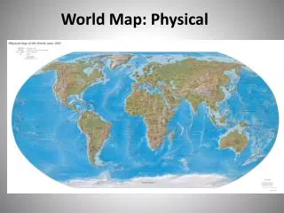
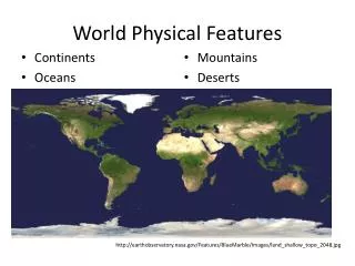
Land and Water • Most of the water of the earth is found in the 4 major oceans. • 71% of the earth is covered with water. • 29% of the earth is land.
Oceans • Pacific Ocean is the largest. It covers 31% of the earths surface. • The Atlantic Ocean is the next largest. It covers 15% of the earth’s surface. • There are more islands in the Pacific than the Atlantic.
The Indian Ocean is slightly smaller than the Atlantic and covers 13% of the earth. • The Arctic Ocean is the smallest and much of this ocean has a frozen surface.
Continents • 29% of the earth’s surface is land. • There are 6 major landmasses. • They are: North America, South America, Africa, Eurasia, Antarctica, Australia.
LandForms • There are 4 major types of landforms. • Mountains • Hills • Plateaus • Plains The earth’s surface is always shifting and changing.
Mountains • Irregular surfaces at high elevations. • Mountains in humid regions are usually rounded. • Those is arid regions are more pointy.
Hills • Similar to, but, lower than mountains.
Plateaus • Are large, flat areas at higher elevations than the surrounding land. • Usually located within montainous or hilly regions and are often drained by rivers and run through deep canyons.
Plains • Extensive regions that are flat and often treeless. • They are drained by rivers that run through shallow valleys.
Landforms by Continent • Eurasia • Mountain ranges including the Himalayas, Alps and Pyrenees. • Northern Eurasia has the largest continuous lowland which includes the Siberian Lowland.
Africa • Much of Africa is a plateau at 1,000 meters above sea level. • The principal mountain range runs north-south on the eastern side of the continent. • Also is largely desert. (Sahara)
North America • Mountains in the west (Rocky Mountains) • Mountains in the east (Appalacians) • Between them is lowland plains.
South America • Mountains in the west (The Andes) • Brazilian Highlands in the east. • Between them are a series of plateaus, plains and river valleys.
Antarctica • Completely covered in ice. • Has mountain ranges.
Australia • Mountain Range = Great Dividing Range • Most of continent is a series of dry plains and plateaus.
Rivers • People almost always live by rivers. There are 6 reasons people are attracted to rivers...
Rivers provide protein-rich food (fish) River valleys provide soils suitable for farming. Rivers provide easy movement of people and goods. Rivers provide opportunities to generate power from hydroelectric dams. Rivers are often favored as locations for recreational activities. Rivers and their valleys provide the best route through wooded areas.
Climate • Climate is the long term balance of temperature, precipitation, wind and cloud cover.
Weather • The short term condition of the atmosphere and can change in a couple of minutes and from one day to the next.
Climate of an Area • 3 main factors combine to determine the climate of an area: • Latitude • Air Masses • Low and High Pressure Zones
Climate Zones • A climate zone is a combination of the 3 main factors that contribute to an areas climate.
Climate Zones • There are 5 climate zones in the world. • Humid-equatorial • Dry • Humid-Temperate • Humid-Cold • Cold-Polar
Ocean Currents • Currents distribute heat throughout the earth.
Prevailing Winds • Wind moves moisture and temperature from one place to another. • Prevailing winds are general wind patterns, much the same as ocean currents.
Mountain Barriers • Mountains block prevailing winds. • Moisture in the air hits the mountain slope, and, because cool air cannot hold as much water, the moisture falls as precipitation. • This leaves the other side of the mountain very dry because it always rains on the other side of the mountain.
Altitude • The altitude of mountains has an effect on climate because air that is high up is cooler and dryer than air that is closer to sea level.
Distribution of Land and Sea • Water absorbs heat more slowly than land, so, the climate of land close to water is moderated by the water. • The water keeps the land cooler during the summer and warmer in the winter.
Environmental Regions • Climate determines soils and vegetation. • Geographers combine climate, soils, and vegetation physical characteristics to identify environmental regions.
Temperate Forests • - Located in Europe and eastern North America. • Naturally forested and have fertile soil. • - Today, these are agricultural or urban with high population density.
Temperate Grasslands • Located in continental interiors. • Examples include: Canadian Prairies, Russian steppes and Argentinean pampas. • There is too little precipitation for trees, but, the soil is good for growing grain and there are clearly defined seasons. • These regions have medium population density.
Mediterranean Forests • Located on the western side of a continent in a temperate latitude. • Summers are hot and dry, and winters are warm and moist. • Naturally forested, these areas are usually agricultural and have medium population density.
Tropical Rainforests • Close to the equator. • High rainfall, and dense vegetation. • The soil is poor for agriculture and the population density is low.
Boreal Forests • Only found in the Northern Hemisphere. • Long cold winters, and short, warm summers. • Low precipitation, little agriculture, and low population density. • Good source of forest products and minerals.